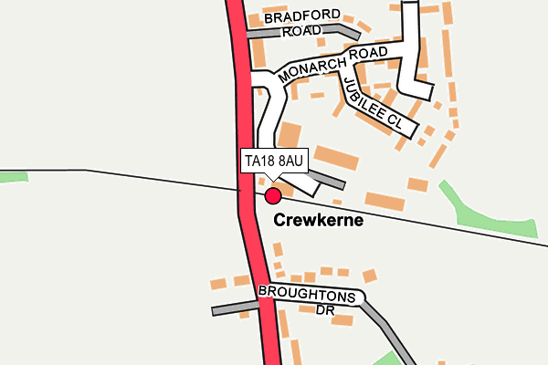
TA18 8AU is located in the Crewkerne electoral ward, within the unitary authority of Somerset and the English Parliamentary constituency of Yeovil. The Sub Integrated Care Board (ICB) Location is NHS Somerset ICB - 11X and the police force is Avon and Somerset. This postcode has been in use since December 1998.


GetTheData
Source: OS OpenMap – Local (Ordnance Survey)
Source: OS VectorMap District (Ordnance Survey)
Licence: Open Government Licence (requires attribution)
| Easting | 345430 |
| Northing | 108521 |
| Latitude | 50.873590 |
| Longitude | -2.776935 |
GetTheData
Source: Open Postcode Geo
Licence: Open Government Licence
| Country | England |
| Postcode District | TA18 |
| ➜ TA18 open data dashboard ➜ See where TA18 is on a map ➜ Where is Misterton? | |
GetTheData
Source: Land Registry Price Paid Data
Licence: Open Government Licence
Elevation or altitude of TA18 8AU as distance above sea level:
| Metres | Feet | |
|---|---|---|
| Elevation | 80m | 262ft |
Elevation is measured from the approximate centre of the postcode, to the nearest point on an OS contour line from OS Terrain 50, which has contour spacing of ten vertical metres.
➜ How high above sea level am I? Find the elevation of your current position using your device's GPS.
GetTheData
Source: Open Postcode Elevation
Licence: Open Government Licence
| Ward | Crewkerne |
| Constituency | Yeovil |
GetTheData
Source: ONS Postcode Database
Licence: Open Government Licence
| November 2023 | Other theft | On or near Petrol Station | 420m |
| June 2022 | Public order | On or near Bradford Road | 202m |
| June 2022 | Violence and sexual offences | On or near Bradford Road | 202m |
| ➜ Get more crime data in our Crime section | |||
GetTheData
Source: data.police.uk
Licence: Open Government Licence
| Crewkerne Railway Station (Station Road) | Misterton | 176m |
| Crewkerne Railway Station (Station Road) | Misterton | 184m |
| The Globe Inn | Misterton | 348m |
| The Globe Inn (Middle Street) | Misterton | 357m |
| The White Swan | Misterton | 721m |
| Crewkerne Station | 0.1km |
GetTheData
Source: NaPTAN
Licence: Open Government Licence
GetTheData
Source: ONS Postcode Database
Licence: Open Government Licence


➜ Get more ratings from the Food Standards Agency
GetTheData
Source: Food Standards Agency
Licence: FSA terms & conditions
| Last Collection | |||
|---|---|---|---|
| Location | Mon-Fri | Sat | Distance |
| Kithill Post Office | 17:00 | 11:45 | 1,027m |
| South Street | 17:00 | 11:00 | 1,286m |
| Lang Road | 16:30 | 11:00 | 1,440m |
GetTheData
Source: Dracos
Licence: Creative Commons Attribution-ShareAlike
| Facility | Distance |
|---|---|
| Misterton Village Hall Unity Lane, Misterton, Crewkerne Sports Hall | 263m |
| Misterton Recreation Ground Unity Lane, Misterton, Crewkerne Grass Pitches, Outdoor Tennis Courts | 345m |
| Happy Valley (Closed) Kithill, Crewkerne Grass Pitches | 1.1km |
GetTheData
Source: Active Places
Licence: Open Government Licence
| School | Phase of Education | Distance |
|---|---|---|
| St Bartholomew's Church of England Primary School Kithill, Crewkerne, TA18 8AS | Primary | 1km |
| Maiden Beech Academy Lyme Road, Crewkerne, TA18 8HG | Primary | 1.7km |
| Perrott Hill School Limited North Perrott, Crewkerne, TA18 7SL | Not applicable | 1.7km |
GetTheData
Source: Edubase
Licence: Open Government Licence
The below table lists the International Territorial Level (ITL) codes (formerly Nomenclature of Territorial Units for Statistics (NUTS) codes) and Local Administrative Units (LAU) codes for TA18 8AU:
| ITL 1 Code | Name |
|---|---|
| TLK | South West (England) |
| ITL 2 Code | Name |
| TLK2 | Dorset and Somerset |
| ITL 3 Code | Name |
| TLK23 | Somerset CC |
| LAU 1 Code | Name |
| E07000189 | South Somerset |
GetTheData
Source: ONS Postcode Directory
Licence: Open Government Licence
The below table lists the Census Output Area (OA), Lower Layer Super Output Area (LSOA), and Middle Layer Super Output Area (MSOA) for TA18 8AU:
| Code | Name | |
|---|---|---|
| OA | E00148676 | |
| LSOA | E01029182 | South Somerset 021A |
| MSOA | E02006095 | South Somerset 021 |
GetTheData
Source: ONS Postcode Directory
Licence: Open Government Licence
| TA18 8FD | Jubilee Close | 75m |
| TA18 8LW | Broughtons Drive | 142m |
| TA18 8FB | Monarch Road | 150m |
| TA18 8LN | Station Road | 173m |
| TA18 8AN | Bradford Road | 197m |
| TA18 8LR | Station Road | 202m |
| TA18 8LP | 246m | |
| TA18 8LU | Middle Street | 307m |
| TA18 8AL | Station Road | 335m |
| TA18 8LX | Middle Street | 349m |
GetTheData
Source: Open Postcode Geo; Land Registry Price Paid Data
Licence: Open Government Licence