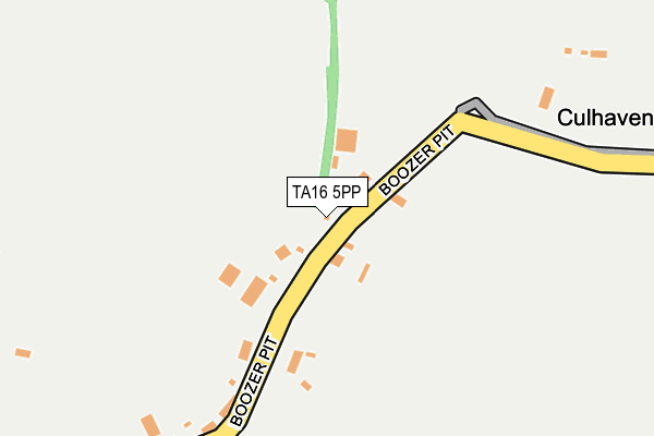
TA16 5PP lies on Green Knapp in Merriott. TA16 5PP is located in the South Petherton & Islemoor electoral ward, within the unitary authority of Somerset and the English Parliamentary constituency of Yeovil. The Sub Integrated Care Board (ICB) Location is NHS Somerset ICB - 11X and the police force is Avon and Somerset. This postcode has been in use since January 1980.


GetTheData
Source: OS OpenMap – Local (Ordnance Survey)
Source: OS VectorMap District (Ordnance Survey)
Licence: Open Government Licence (requires attribution)
| Easting | 344987 |
| Northing | 113393 |
| Latitude | 50.917355 |
| Longitude | -2.783967 |
GetTheData
Source: Open Postcode Geo
Licence: Open Government Licence
| Street | Green Knapp |
| Town/City | Merriott |
| Country | England |
| Postcode District | TA16 |
| ➜ TA16 open data dashboard ➜ See where TA16 is on a map | |
GetTheData
Source: Land Registry Price Paid Data
Licence: Open Government Licence
Elevation or altitude of TA16 5PP as distance above sea level:
| Metres | Feet | |
|---|---|---|
| Elevation | 40m | 131ft |
Elevation is measured from the approximate centre of the postcode, to the nearest point on an OS contour line from OS Terrain 50, which has contour spacing of ten vertical metres.
➜ How high above sea level am I? Find the elevation of your current position using your device's GPS.
GetTheData
Source: Open Postcode Elevation
Licence: Open Government Licence
| Ward | South Petherton & Islemoor |
| Constituency | Yeovil |
GetTheData
Source: ONS Postcode Database
Licence: Open Government Licence
| November 2021 | Other theft | On or near Boozer Pit | 143m |
| ➜ Get more crime data in our Crime section | |||
GetTheData
Source: data.police.uk
Licence: Open Government Licence
| The Church (Church Street) | Merriott | 955m |
| The Church | Merriott | 962m |
| Langdons Cottage (Lower Street) | Merriottsford | 1,330m |
| The Old Chapel (Lower Street) | Merriottsford | 1,342m |
| Broadway Stores (Broadway) | Merriott | 1,411m |
| Crewkerne Station | 4.9km |
GetTheData
Source: NaPTAN
Licence: Open Government Licence
| Percentage of properties with Next Generation Access | 100.0% |
| Percentage of properties with Superfast Broadband | 0.0% |
| Percentage of properties with Ultrafast Broadband | 0.0% |
| Percentage of properties with Full Fibre Broadband | 0.0% |
Superfast Broadband is between 30Mbps and 300Mbps
Ultrafast Broadband is > 300Mbps
| Percentage of properties unable to receive 2Mbps | 0.0% |
| Percentage of properties unable to receive 5Mbps | 0.0% |
| Percentage of properties unable to receive 10Mbps | 0.0% |
| Percentage of properties unable to receive 30Mbps | 100.0% |
GetTheData
Source: Ofcom
Licence: Ofcom Terms of Use (requires attribution)
GetTheData
Source: ONS Postcode Database
Licence: Open Government Licence


➜ Get more ratings from the Food Standards Agency
GetTheData
Source: Food Standards Agency
Licence: FSA terms & conditions
| Last Collection | |||
|---|---|---|---|
| Location | Mon-Fri | Sat | Distance |
| Merriot Post Office | 16:45 | 11:00 | 1,404m |
| Hinton St George | 16:30 | 09:30 | 2,972m |
| East Street Post Office | 17:15 | 12:00 | 3,659m |
GetTheData
Source: Dracos
Licence: Creative Commons Attribution-ShareAlike
| Facility | Distance |
|---|---|
| Merriott Squash Club Lower Street, Merriott Squash Courts | 870m |
| Merriott Recreation Ground Broadway, Merriott Grass Pitches, Outdoor Tennis Courts | 1.5km |
| Vaux Park Polo Club Wigborough, South Petherton Grass Pitches | 1.8km |
GetTheData
Source: Active Places
Licence: Open Government Licence
| School | Phase of Education | Distance |
|---|---|---|
| Merriott Primary School Church Street, Merriott, TA16 5PT | Primary | 1km |
| West Chinnock Church School Scotts Way, West Chinnock, Crewkerne, TA18 7PU | Primary | 1.8km |
| West Chinnock Church of England Primary School Scotts Way, West Chinnock, Crewkerne, TA18 7PU | Primary | 1.8km |
GetTheData
Source: Edubase
Licence: Open Government Licence
The below table lists the International Territorial Level (ITL) codes (formerly Nomenclature of Territorial Units for Statistics (NUTS) codes) and Local Administrative Units (LAU) codes for TA16 5PP:
| ITL 1 Code | Name |
|---|---|
| TLK | South West (England) |
| ITL 2 Code | Name |
| TLK2 | Dorset and Somerset |
| ITL 3 Code | Name |
| TLK23 | Somerset CC |
| LAU 1 Code | Name |
| E07000189 | South Somerset |
GetTheData
Source: ONS Postcode Directory
Licence: Open Government Licence
The below table lists the Census Output Area (OA), Lower Layer Super Output Area (LSOA), and Middle Layer Super Output Area (MSOA) for TA16 5PP:
| Code | Name | |
|---|---|---|
| OA | E00148695 | |
| LSOA | E01029190 | South Somerset 017B |
| MSOA | E02006091 | South Somerset 017 |
GetTheData
Source: ONS Postcode Directory
Licence: Open Government Licence
| TA16 5PW | Boozer Pit | 244m |
| TA16 5PJ | Higher Street | 489m |
| TA16 5PN | Townsend Orchard | 526m |
| TA16 5PA | Church Street | 628m |
| TA16 5PR | Church Street | 712m |
| TA16 5PH | Shiremoor Hill | 712m |
| TA16 5PS | Church Street | 858m |
| TA16 5QR | Sandyhole | 953m |
| TA16 5NP | Lower Street | 960m |
| TA16 5NW | Lower Street | 1003m |
GetTheData
Source: Open Postcode Geo; Land Registry Price Paid Data
Licence: Open Government Licence