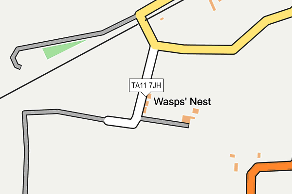
TA11 7JH is in Catcombe, Somerton. TA11 7JH is located in the Somerton electoral ward, within the unitary authority of Somerset and the English Parliamentary constituency of Somerton and Frome. The Sub Integrated Care Board (ICB) Location is NHS Somerset ICB - 11X and the police force is Avon and Somerset. This postcode has been in use since January 1980.


GetTheData
Source: OS OpenMap – Local (Ordnance Survey)
Source: OS VectorMap District (Ordnance Survey)
Licence: Open Government Licence (requires attribution)
| Easting | 347700 |
| Northing | 127619 |
| Latitude | 51.045529 |
| Longitude | -2.747426 |
GetTheData
Source: Open Postcode Geo
Licence: Open Government Licence
| Locality | Catcombe |
| Town/City | Somerton |
| Country | England |
| Postcode District | TA11 |
| ➜ TA11 open data dashboard ➜ See where TA11 is on a map | |
GetTheData
Source: Land Registry Price Paid Data
Licence: Open Government Licence
Elevation or altitude of TA11 7JH as distance above sea level:
| Metres | Feet | |
|---|---|---|
| Elevation | 40m | 131ft |
Elevation is measured from the approximate centre of the postcode, to the nearest point on an OS contour line from OS Terrain 50, which has contour spacing of ten vertical metres.
➜ How high above sea level am I? Find the elevation of your current position using your device's GPS.
GetTheData
Source: Open Postcode Elevation
Licence: Open Government Licence
| Ward | Somerton |
| Constituency | Somerton And Frome |
GetTheData
Source: ONS Postcode Database
Licence: Open Government Licence
| July 2021 | Public order | On or near Windyridge Lane | 489m |
| July 2021 | Violence and sexual offences | On or near Windyridge Lane | 489m |
| ➜ Get more crime data in our Crime section | |||
GetTheData
Source: data.police.uk
Licence: Open Government Licence
| Woodlands (Sutton Road) | Long Sutton | 725m |
| Woodlands (Sutton Road) | Long Sutton | 735m |
| Bincombe Road Trading Estate | Somerton Hill | 964m |
| Bincombe Road Trading Estate (Langport Road) | Somerton Hill | 983m |
| Garden Cottage (Gassons Lane) | Somerton | 1,038m |
GetTheData
Source: NaPTAN
Licence: Open Government Licence
| Percentage of properties with Next Generation Access | 100.0% |
| Percentage of properties with Superfast Broadband | 0.0% |
| Percentage of properties with Ultrafast Broadband | 0.0% |
| Percentage of properties with Full Fibre Broadband | 0.0% |
Superfast Broadband is between 30Mbps and 300Mbps
Ultrafast Broadband is > 300Mbps
| Percentage of properties unable to receive 2Mbps | 0.0% |
| Percentage of properties unable to receive 5Mbps | 0.0% |
| Percentage of properties unable to receive 10Mbps | 33.3% |
| Percentage of properties unable to receive 30Mbps | 100.0% |
GetTheData
Source: Ofcom
Licence: Ofcom Terms of Use (requires attribution)
GetTheData
Source: ONS Postcode Database
Licence: Open Government Licence


➜ Get more ratings from the Food Standards Agency
GetTheData
Source: Food Standards Agency
Licence: FSA terms & conditions
| Last Collection | |||
|---|---|---|---|
| Location | Mon-Fri | Sat | Distance |
| Poundpool | 17:15 | 09:00 | 1,285m |
| Somerton Post Office | 17:15 | 11:30 | 1,350m |
| Market Square | 17:15 | 08:45 | 1,631m |
GetTheData
Source: Dracos
Licence: Creative Commons Attribution-ShareAlike
| Facility | Distance |
|---|---|
| Somerton Recreation Ground Gassons Lane, Somerton Grass Pitches, Outdoor Tennis Courts | 973m |
| King Ina Church Of England Academy Northfield, Northfield, Somerton Grass Pitches | 1.6km |
| King Ina C Of E Academy Playing Field Kirkham Street, Kirkham Street, Somerton Grass Pitches | 1.8km |
GetTheData
Source: Active Places
Licence: Open Government Licence
| School | Phase of Education | Distance |
|---|---|---|
| King Ina Church of England Academy Northfield, Somerton, TA11 6FQ | Primary | 1.6km |
| Long Sutton CofE Primary School Martock Road, Long Sutton, Langport, TA10 9NT | Primary | 2.2km |
| Compton Dundon School School Lane, Compton Dundon, Somerton, Somerset, TA11 6TE | Not applicable | 4.9km |
GetTheData
Source: Edubase
Licence: Open Government Licence
The below table lists the International Territorial Level (ITL) codes (formerly Nomenclature of Territorial Units for Statistics (NUTS) codes) and Local Administrative Units (LAU) codes for TA11 7JH:
| ITL 1 Code | Name |
|---|---|
| TLK | South West (England) |
| ITL 2 Code | Name |
| TLK2 | Dorset and Somerset |
| ITL 3 Code | Name |
| TLK23 | Somerset CC |
| LAU 1 Code | Name |
| E07000189 | South Somerset |
GetTheData
Source: ONS Postcode Directory
Licence: Open Government Licence
The below table lists the Census Output Area (OA), Lower Layer Super Output Area (LSOA), and Middle Layer Super Output Area (MSOA) for TA11 7JH:
| Code | Name | |
|---|---|---|
| OA | E00148876 | |
| LSOA | E01029224 | South Somerset 003A |
| MSOA | E02006077 | South Somerset 003 |
GetTheData
Source: ONS Postcode Directory
Licence: Open Government Licence
| TA11 7JG | South Hill | 481m |
| TA11 7JN | Mill Lane | 544m |
| TA11 6PL | Blackthorn Way | 597m |
| TA11 6QY | St Cleers Orchard | 628m |
| TA11 6PH | Barn Close | 629m |
| TA11 7JF | Badgers Cross Lane | 643m |
| TA11 6PJ | Farm Drive | 659m |
| TA11 6QX | St Cleers Orchard | 666m |
| TA11 6PN | Ricksey Close | 684m |
| TA11 6QE | Farm Close | 707m |
GetTheData
Source: Open Postcode Geo; Land Registry Price Paid Data
Licence: Open Government Licence