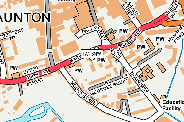
TA1 3NW is located in the Bishop's Hull & Taunton West electoral ward, within the unitary authority of Somerset and the English Parliamentary constituency of Taunton Deane. The Sub Integrated Care Board (ICB) Location is NHS Somerset ICB - 11X and the police force is Avon and Somerset. This postcode has been in use since February 1990.


GetTheData
Source: OS OpenMap – Local (Ordnance Survey)
Source: OS VectorMap District (Ordnance Survey)
Licence: Open Government Licence (requires attribution)
| Easting | 322842 |
| Northing | 124237 |
| Latitude | 51.012317 |
| Longitude | -3.101241 |
GetTheData
Source: Open Postcode Geo
Licence: Open Government Licence
| Country | England |
| Postcode District | TA1 |
| ➜ TA1 open data dashboard ➜ See where TA1 is on a map ➜ Where is Taunton? | |
GetTheData
Source: Land Registry Price Paid Data
Licence: Open Government Licence
Elevation or altitude of TA1 3NW as distance above sea level:
| Metres | Feet | |
|---|---|---|
| Elevation | 20m | 66ft |
Elevation is measured from the approximate centre of the postcode, to the nearest point on an OS contour line from OS Terrain 50, which has contour spacing of ten vertical metres.
➜ How high above sea level am I? Find the elevation of your current position using your device's GPS.
GetTheData
Source: Open Postcode Elevation
Licence: Open Government Licence
| Ward | Bishop's Hull & Taunton West |
| Constituency | Taunton Deane |
GetTheData
Source: ONS Postcode Database
Licence: Open Government Licence
| January 2024 | Anti-social behaviour | On or near Corporation Street | 361m |
| January 2024 | Anti-social behaviour | On or near Corporation Street | 361m |
| January 2024 | Violence and sexual offences | On or near Corporation Street | 361m |
| ➜ Get more crime data in our Crime section | |||
GetTheData
Source: data.police.uk
Licence: Open Government Licence
| Waterstones (East Street) | Taunton | 225m |
| Market House | Taunton | 265m |
| The Parade | Taunton | 296m |
| The Parade (Fore Street) | Taunton | 296m |
| Corporation Street | Taunton | 323m |
| Taunton Station | 1.2km |
GetTheData
Source: NaPTAN
Licence: Open Government Licence
GetTheData
Source: ONS Postcode Database
Licence: Open Government Licence


➜ Get more ratings from the Food Standards Agency
GetTheData
Source: Food Standards Agency
Licence: FSA terms & conditions
| Last Collection | |||
|---|---|---|---|
| Location | Mon-Fri | Sat | Distance |
| The Crescent | 17:15 | 11:45 | 286m |
| East Reach | 17:00 | 11:45 | 441m |
| Taunton Main Post Office | 17:30 | 12:30 | 456m |
GetTheData
Source: Dracos
Licence: Creative Commons Attribution-ShareAlike
| Facility | Distance |
|---|---|
| St Georges Catholic School The Mount, Taunton Swimming Pool, Sports Hall, Grass Pitches | 177m |
| Anytime Fitness (Taunton) Orchard Centre, Taunton Health and Fitness Gym, Studio | 182m |
| Taunton Bowling Club Fons George, Taunton Indoor Bowls | 235m |
GetTheData
Source: Active Places
Licence: Open Government Licence
| School | Phase of Education | Distance |
|---|---|---|
| St George's Catholic School The Mount, Taunton, TA1 3NR | Primary | 177m |
| Silver Bridge School 54 Silver Street, Taunton, Somerset, TA1 3DL | Not applicable | 356m |
| King's College Taunton South Road, Taunton, TA1 3LA | Not applicable | 389m |
GetTheData
Source: Edubase
Licence: Open Government Licence
The below table lists the International Territorial Level (ITL) codes (formerly Nomenclature of Territorial Units for Statistics (NUTS) codes) and Local Administrative Units (LAU) codes for TA1 3NW:
| ITL 1 Code | Name |
|---|---|
| TLK | South West (England) |
| ITL 2 Code | Name |
| TLK2 | Dorset and Somerset |
| ITL 3 Code | Name |
| TLK23 | Somerset CC |
| LAU 1 Code | Name |
| E07000246 | Somerset West and Taunton |
GetTheData
Source: ONS Postcode Directory
Licence: Open Government Licence
The below table lists the Census Output Area (OA), Lower Layer Super Output Area (LSOA), and Middle Layer Super Output Area (MSOA) for TA1 3NW:
| Code | Name | |
|---|---|---|
| OA | E00149282 | |
| LSOA | E01029301 | Taunton Deane 010D |
| MSOA | E02006108 | Taunton Deane 010 |
GetTheData
Source: ONS Postcode Directory
Licence: Open Government Licence
| TA1 3RX | St Georges Square | 68m |
| TA1 3QF | Mount Street | 111m |
| TA1 3PF | Paul Street | 129m |
| TA1 3TA | St Georges Mews | 132m |
| TA1 3QB | Mount Street | 138m |
| TA1 3NN | Billetfield | 138m |
| TA1 3PJ | High Street | 150m |
| TA1 3PN | High Street | 169m |
| TA1 3NG | Billet Street | 178m |
| TA1 3RZ | The Mount | 181m |
GetTheData
Source: Open Postcode Geo; Land Registry Price Paid Data
Licence: Open Government Licence