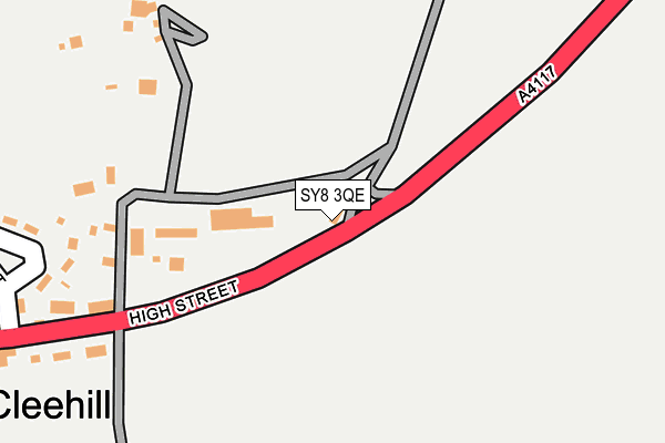
SY8 3QE is located in the Cleobury Mortimer electoral ward, within the unitary authority of Shropshire and the English Parliamentary constituency of Ludlow. The Sub Integrated Care Board (ICB) Location is NHS Shropshire, Telford and Wrekin ICB - M2L0M and the police force is West Mercia. This postcode has been in use since October 2003.


GetTheData
Source: OS OpenMap – Local (Ordnance Survey)
Source: OS VectorMap District (Ordnance Survey)
Licence: Open Government Licence (requires attribution)
| Easting | 359657 |
| Northing | 275439 |
| Latitude | 52.375510 |
| Longitude | -2.594036 |
GetTheData
Source: Open Postcode Geo
Licence: Open Government Licence
| Country | England |
| Postcode District | SY8 |
| ➜ SY8 open data dashboard ➜ See where SY8 is on a map ➜ Where is Cleehill? | |
GetTheData
Source: Land Registry Price Paid Data
Licence: Open Government Licence
Elevation or altitude of SY8 3QE as distance above sea level:
| Metres | Feet | |
|---|---|---|
| Elevation | 380m | 1,247ft |
Elevation is measured from the approximate centre of the postcode, to the nearest point on an OS contour line from OS Terrain 50, which has contour spacing of ten vertical metres.
➜ How high above sea level am I? Find the elevation of your current position using your device's GPS.
GetTheData
Source: Open Postcode Elevation
Licence: Open Government Licence
| Ward | Cleobury Mortimer |
| Constituency | Ludlow |
GetTheData
Source: ONS Postcode Database
Licence: Open Government Licence
| May 2022 | Violence and sexual offences | On or near The Crescent | 337m |
| April 2022 | Public order | On or near The Crescent | 337m |
| April 2022 | Anti-social behaviour | On or near Titterstone Close | 408m |
| ➜ Get more crime data in our Crime section | |||
GetTheData
Source: data.police.uk
Licence: Open Government Licence
| Mace Stores (High Street) | Clee Hill | 323m |
| Mace Stores (High Street) | Clee Hill | 324m |
| Golden Cross Inn (High Street) | Clee Hill | 360m |
| Golden Cross Inn (High Street) | Clee Hill | 361m |
| Shelter (Ludlow Road) | Clee Hill | 530m |
GetTheData
Source: NaPTAN
Licence: Open Government Licence
GetTheData
Source: ONS Postcode Database
Licence: Open Government Licence


➜ Get more ratings from the Food Standards Agency
GetTheData
Source: Food Standards Agency
Licence: FSA terms & conditions
| Last Collection | |||
|---|---|---|---|
| Location | Mon-Fri | Sat | Distance |
| Clee Hill Post Office | 16:30 | 11:30 | 350m |
| Royal Oak | 11:30 | 11:30 | 1,538m |
| Clee Stanton | 11:30 | 11:30 | 4,465m |
GetTheData
Source: Dracos
Licence: Creative Commons Attribution-ShareAlike
| Facility | Distance |
|---|---|
| Clee Hill Recreation Field High Street, Clee Hill, Ludlow Grass Pitches | 341m |
| Clee Hill Community Academy Tenbury Road, Clee Hill, Ludlow Grass Pitches | 514m |
| Clee Hill Rugby Club (Tenbury Road) Tenbury Road, Clee Hill, Ludlow Grass Pitches | 1.2km |
GetTheData
Source: Active Places
Licence: Open Government Licence
| School | Phase of Education | Distance |
|---|---|---|
| Clee Hill Community Academy Tenbury Road, Clee Hill, Ludlow, SY8 3NE | Primary | 514m |
| Bitterley CofE Primary School (Aided) Bitterley, Ludlow, SY8 3HF | Primary | 4km |
GetTheData
Source: Edubase
Licence: Open Government Licence
The below table lists the International Territorial Level (ITL) codes (formerly Nomenclature of Territorial Units for Statistics (NUTS) codes) and Local Administrative Units (LAU) codes for SY8 3QE:
| ITL 1 Code | Name |
|---|---|
| TLG | West Midlands (England) |
| ITL 2 Code | Name |
| TLG2 | Shropshire and Staffordshire |
| ITL 3 Code | Name |
| TLG22 | Shropshire |
| LAU 1 Code | Name |
| E06000051 | Shropshire |
GetTheData
Source: ONS Postcode Directory
Licence: Open Government Licence
The below table lists the Census Output Area (OA), Lower Layer Super Output Area (LSOA), and Middle Layer Super Output Area (MSOA) for SY8 3QE:
| Code | Name | |
|---|---|---|
| OA | E00147690 | |
| LSOA | E01029000 | Shropshire 039D |
| MSOA | E02006046 | Shropshire 039 |
GetTheData
Source: ONS Postcode Directory
Licence: Open Government Licence
| SY8 3QF | 92m | |
| SY8 3PZ | Stratton Cottages | 285m |
| SY8 3NB | 289m | |
| SY8 3ND | 320m | |
| SY8 3PY | Rose Cottages | 323m |
| SY8 3LZ | High Street | 330m |
| SY8 3NA | The Crescent | 332m |
| SY8 3QZ | Titterstone Close | 394m |
| SY8 3QY | Springfield Park | 403m |
| SY8 3RF | Belfry Close | 404m |
GetTheData
Source: Open Postcode Geo; Land Registry Price Paid Data
Licence: Open Government Licence