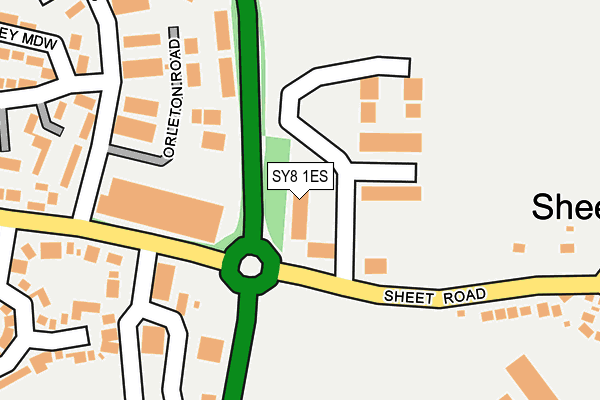
SY8 1ES is located in the Ludlow South electoral ward, within the unitary authority of Shropshire and the English Parliamentary constituency of Ludlow. The Sub Integrated Care Board (ICB) Location is NHS Shropshire, Telford and Wrekin ICB - M2L0M and the police force is West Mercia. This postcode has been in use since February 2007.


GetTheData
Source: OS OpenMap – Local (Ordnance Survey)
Source: OS VectorMap District (Ordnance Survey)
Licence: Open Government Licence (requires attribution)
| Easting | 352843 |
| Northing | 274353 |
| Latitude | 52.365188 |
| Longitude | -2.693971 |
GetTheData
Source: Open Postcode Geo
Licence: Open Government Licence
| Country | England |
| Postcode District | SY8 |
| ➜ SY8 open data dashboard ➜ See where SY8 is on a map ➜ Where is Sheet? | |
GetTheData
Source: Land Registry Price Paid Data
Licence: Open Government Licence
Elevation or altitude of SY8 1ES as distance above sea level:
| Metres | Feet | |
|---|---|---|
| Elevation | 110m | 361ft |
Elevation is measured from the approximate centre of the postcode, to the nearest point on an OS contour line from OS Terrain 50, which has contour spacing of ten vertical metres.
➜ How high above sea level am I? Find the elevation of your current position using your device's GPS.
GetTheData
Source: Open Postcode Elevation
Licence: Open Government Licence
| Ward | Ludlow South |
| Constituency | Ludlow |
GetTheData
Source: ONS Postcode Database
Licence: Open Government Licence
| November 2023 | Violence and sexual offences | On or near Parking Area | 179m |
| October 2023 | Violence and sexual offences | On or near Parking Area | 179m |
| October 2023 | Violence and sexual offences | On or near Overton View | 359m |
| ➜ Get more crime data in our Crime section | |||
GetTheData
Source: data.police.uk
Licence: Open Government Licence
| Eco Park & Ride (Eco Park) | Ludlow | 57m |
| Eco Park Entrance (Industrial Estate) | Ludlow | 72m |
| Eco Park Entrance (Industrial Estate) | Ludlow | 79m |
| Depot (Parys Road) | Ludlow | 208m |
| Depot (Parys Road) | Ludlow | 218m |
| Ludlow Station | 1.7km |
GetTheData
Source: NaPTAN
Licence: Open Government Licence
GetTheData
Source: ONS Postcode Database
Licence: Open Government Licence


➜ Get more ratings from the Food Standards Agency
GetTheData
Source: Food Standards Agency
Licence: FSA terms & conditions
| Last Collection | |||
|---|---|---|---|
| Location | Mon-Fri | Sat | Distance |
| Gravel Hill | 17:00 | 10:45 | 1,460m |
| Tower Street Post Office | 17:45 | 12:30 | 1,566m |
| Bull Ring | 17:45 | 11:45 | 1,637m |
GetTheData
Source: Dracos
Licence: Creative Commons Attribution-ShareAlike
| Facility | Distance |
|---|---|
| St Laurence Cofe Primary School Jockey Fields, Ludlow Grass Pitches | 1.4km |
| Ludlow College Castle Square, Ludlow Health and Fitness Gym, Sports Hall | 1.9km |
| Ludlow Rugby Football Club Linney, Ludlow Grass Pitches | 2.2km |
GetTheData
Source: Active Places
Licence: Open Government Licence
| School | Phase of Education | Distance |
|---|---|---|
| Ludlow Primary School Clee View, Ludlow, SY8 1HX | Primary | 1.1km |
| St Laurence CofE Primary School Jockeyfield, Ludlow, SY8 1TP | Primary | 1.4km |
| Ludlow Church of England School Bromfield Road, Burway, Ludlow, SY8 1GJ | Secondary | 2.7km |
GetTheData
Source: Edubase
Licence: Open Government Licence
The below table lists the International Territorial Level (ITL) codes (formerly Nomenclature of Territorial Units for Statistics (NUTS) codes) and Local Administrative Units (LAU) codes for SY8 1ES:
| ITL 1 Code | Name |
|---|---|
| TLG | West Midlands (England) |
| ITL 2 Code | Name |
| TLG2 | Shropshire and Staffordshire |
| ITL 3 Code | Name |
| TLG22 | Shropshire |
| LAU 1 Code | Name |
| E06000051 | Shropshire |
GetTheData
Source: ONS Postcode Directory
Licence: Open Government Licence
The below table lists the Census Output Area (OA), Lower Layer Super Output Area (LSOA), and Middle Layer Super Output Area (MSOA) for SY8 1ES:
| Code | Name | |
|---|---|---|
| OA | E00174584 | |
| LSOA | E01029012 | Shropshire 038G |
| MSOA | E02006045 | Shropshire 038 |
GetTheData
Source: ONS Postcode Directory
Licence: Open Government Licence
| SY8 1LS | Foldgate Lane | 205m |
| SY8 1XB | Parys Road | 232m |
| SY8 1NB | Foldgate View | 278m |
| SY8 1XE | Coder Road | 312m |
| SY8 1LR | Sheet Road | 325m |
| SY8 1TG | Honey Meadow | 335m |
| SY8 1UF | Langford Close | 345m |
| SY8 1LZ | Greenacres | 352m |
| SY8 4NB | Ledwyche Court | 360m |
| SY8 4JT | 383m |
GetTheData
Source: Open Postcode Geo; Land Registry Price Paid Data
Licence: Open Government Licence