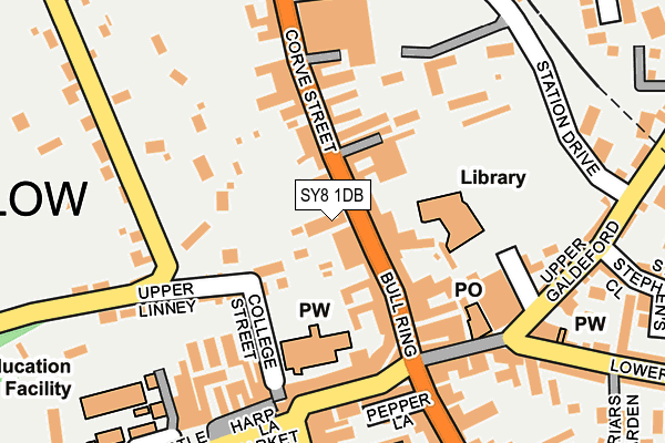
SY8 1DB lies on Corve Street in Ludlow. SY8 1DB is located in the Ludlow North electoral ward, within the unitary authority of Shropshire and the English Parliamentary constituency of Ludlow. The Sub Integrated Care Board (ICB) Location is NHS Shropshire, Telford and Wrekin ICB - M2L0M and the police force is West Mercia. This postcode has been in use since January 1980.


GetTheData
Source: OS OpenMap – Local (Ordnance Survey)
Source: OS VectorMap District (Ordnance Survey)
Licence: Open Government Licence (requires attribution)
| Easting | 351176 |
| Northing | 274822 |
| Latitude | 52.369271 |
| Longitude | -2.718518 |
GetTheData
Source: Open Postcode Geo
Licence: Open Government Licence
| Street | Corve Street |
| Town/City | Ludlow |
| Country | England |
| Postcode District | SY8 |
| ➜ SY8 open data dashboard ➜ See where SY8 is on a map ➜ Where is Ludlow? | |
GetTheData
Source: Land Registry Price Paid Data
Licence: Open Government Licence
Elevation or altitude of SY8 1DB as distance above sea level:
| Metres | Feet | |
|---|---|---|
| Elevation | 100m | 328ft |
Elevation is measured from the approximate centre of the postcode, to the nearest point on an OS contour line from OS Terrain 50, which has contour spacing of ten vertical metres.
➜ How high above sea level am I? Find the elevation of your current position using your device's GPS.
GetTheData
Source: Open Postcode Elevation
Licence: Open Government Licence
| Ward | Ludlow North |
| Constituency | Ludlow |
GetTheData
Source: ONS Postcode Database
Licence: Open Government Licence
| January 2024 | Shoplifting | On or near Supermarket | 192m |
| January 2024 | Anti-social behaviour | On or near Supermarket | 192m |
| January 2024 | Criminal damage and arson | On or near Parking Area | 200m |
| ➜ Get more crime data in our Crime section | |||
GetTheData
Source: data.police.uk
Licence: Open Government Licence
| Compasses Inn (Corve Street) | Ludlow | 33m |
| Compasses Inn (Corve Street) | Ludlow | 42m |
| Tesco (Station Drive) | Ludlow | 211m |
| Cooperative Store (Upper Galdeford) | Ludlow | 217m |
| Surgery (Station Drive) | Ludlow | 219m |
| Ludlow Station | 0.3km |
GetTheData
Source: NaPTAN
Licence: Open Government Licence
GetTheData
Source: ONS Postcode Database
Licence: Open Government Licence


➜ Get more ratings from the Food Standards Agency
GetTheData
Source: Food Standards Agency
Licence: FSA terms & conditions
| Last Collection | |||
|---|---|---|---|
| Location | Mon-Fri | Sat | Distance |
| Bull Ring | 17:45 | 11:45 | 154m |
| Tower Street Post Office | 17:45 | 12:30 | 177m |
| Cattle/Market Square | 17:30 | 11:30 | 221m |
GetTheData
Source: Dracos
Licence: Creative Commons Attribution-ShareAlike
| Facility | Distance |
|---|---|
| Ludlow College Castle Square, Ludlow Health and Fitness Gym, Sports Hall | 282m |
| Ludlow Rugby Football Club Linney, Ludlow Grass Pitches | 429m |
| St Laurence Cofe Primary School Jockey Fields, Ludlow Grass Pitches | 455m |
GetTheData
Source: Active Places
Licence: Open Government Licence
| School | Phase of Education | Distance |
|---|---|---|
| St Laurence CofE Primary School Jockeyfield, Ludlow, SY8 1TP | Primary | 455m |
| Ludlow Church of England School Bromfield Road, Burway, Ludlow, SY8 1GJ | Secondary | 1.1km |
| Ludlow Primary School Clee View, Ludlow, SY8 1HX | Primary | 1.2km |
GetTheData
Source: Edubase
Licence: Open Government Licence
The below table lists the International Territorial Level (ITL) codes (formerly Nomenclature of Territorial Units for Statistics (NUTS) codes) and Local Administrative Units (LAU) codes for SY8 1DB:
| ITL 1 Code | Name |
|---|---|
| TLG | West Midlands (England) |
| ITL 2 Code | Name |
| TLG2 | Shropshire and Staffordshire |
| ITL 3 Code | Name |
| TLG22 | Shropshire |
| LAU 1 Code | Name |
| E06000051 | Shropshire |
GetTheData
Source: ONS Postcode Directory
Licence: Open Government Licence
The below table lists the Census Output Area (OA), Lower Layer Super Output Area (LSOA), and Middle Layer Super Output Area (MSOA) for SY8 1DB:
| Code | Name | |
|---|---|---|
| OA | E00147734 | |
| LSOA | E01033527 | Shropshire 038I |
| MSOA | E02006045 | Shropshire 038 |
GetTheData
Source: ONS Postcode Directory
Licence: Open Government Licence
| SY8 2PG | Corve Street | 48m |
| SY8 1AD | Bull Ring | 84m |
| SY8 1AA | Bull Ring | 103m |
| SY8 1BF | Portcullis Lane | 109m |
| SY8 1EF | Upper Linney | 111m |
| SY8 1DA | Corve Street | 112m |
| SY8 1AL | Church Walk | 125m |
| SY8 1AN | College Street | 132m |
| SY8 1AQ | King Street | 151m |
| SY8 1PZ | Corve Street | 151m |
GetTheData
Source: Open Postcode Geo; Land Registry Price Paid Data
Licence: Open Government Licence