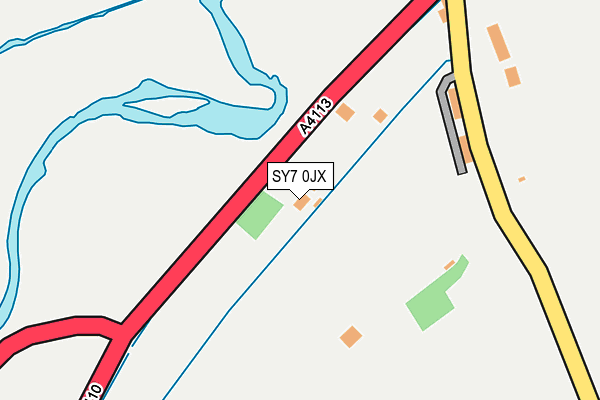
SY7 0JX is in Leintwardine, Craven Arms. SY7 0JX is located in the Mortimer electoral ward, within the unitary authority of Herefordshire, County of and the English Parliamentary constituency of North Herefordshire. The Sub Integrated Care Board (ICB) Location is NHS Herefordshire and Worcestershire ICB - 18C and the police force is West Mercia. This postcode has been in use since January 1980.


GetTheData
Source: OS OpenMap – Local (Ordnance Survey)
Source: OS VectorMap District (Ordnance Survey)
Licence: Open Government Licence (requires attribution)
| Easting | 340295 |
| Northing | 273631 |
| Latitude | 52.357485 |
| Longitude | -2.878101 |
GetTheData
Source: Open Postcode Geo
Licence: Open Government Licence
| Locality | Leintwardine |
| Town/City | Craven Arms |
| Country | England |
| Postcode District | SY7 |
➜ See where SY7 is on a map ➜ Where is Leintwardine? | |
GetTheData
Source: Land Registry Price Paid Data
Licence: Open Government Licence
Elevation or altitude of SY7 0JX as distance above sea level:
| Metres | Feet | |
|---|---|---|
| Elevation | 120m | 394ft |
Elevation is measured from the approximate centre of the postcode, to the nearest point on an OS contour line from OS Terrain 50, which has contour spacing of ten vertical metres.
➜ How high above sea level am I? Find the elevation of your current position using your device's GPS.
GetTheData
Source: Open Postcode Elevation
Licence: Open Government Licence
| Ward | Mortimer |
| Constituency | North Herefordshire |
GetTheData
Source: ONS Postcode Database
Licence: Open Government Licence
BROCKLEY VILLA, LEINTWARDINE, CRAVEN ARMS, SY7 0JX 2014 14 APR £295,000 |
GetTheData
Source: HM Land Registry Price Paid Data
Licence: Contains HM Land Registry data © Crown copyright and database right 2025. This data is licensed under the Open Government Licence v3.0.
| Lion Hotel (Rosemary Lane) | Leintwardine | 290m |
| The Criftins (A4113. High Street) | Leintwardine | 780m |
| Adforton Turn (A4113) | Walford | 1,470m |
| Adforton Turn (A4113) | Walford | 1,481m |
| Hopton Heath Station | 4.4km |
| Bucknell Station | 4.7km |
GetTheData
Source: NaPTAN
Licence: Open Government Licence
| Percentage of properties with Next Generation Access | 100.0% |
| Percentage of properties with Superfast Broadband | 100.0% |
| Percentage of properties with Ultrafast Broadband | 0.0% |
| Percentage of properties with Full Fibre Broadband | 0.0% |
Superfast Broadband is between 30Mbps and 300Mbps
Ultrafast Broadband is > 300Mbps
| Percentage of properties unable to receive 2Mbps | 0.0% |
| Percentage of properties unable to receive 5Mbps | 0.0% |
| Percentage of properties unable to receive 10Mbps | 0.0% |
| Percentage of properties unable to receive 30Mbps | 0.0% |
GetTheData
Source: Ofcom
Licence: Ofcom Terms of Use (requires attribution)
GetTheData
Source: ONS Postcode Database
Licence: Open Government Licence


➜ Get more ratings from the Food Standards Agency
GetTheData
Source: Food Standards Agency
Licence: FSA terms & conditions
| Last Collection | |||
|---|---|---|---|
| Location | Mon-Fri | Sat | Distance |
| Church Street | 16:45 | 11:00 | 424m |
| Criftins | 16:45 | 11:00 | 773m |
| Paytoe | 09:15 | 09:15 | 2,280m |
GetTheData
Source: Dracos
Licence: Creative Commons Attribution-ShareAlike
| Risk of SY7 0JX flooding from rivers and sea | High |
| ➜ SY7 0JX flood map | |
GetTheData
Source: Open Flood Risk by Postcode
Licence: Open Government Licence
The below table lists the International Territorial Level (ITL) codes (formerly Nomenclature of Territorial Units for Statistics (NUTS) codes) and Local Administrative Units (LAU) codes for SY7 0JX:
| ITL 1 Code | Name |
|---|---|
| TLG | West Midlands (England) |
| ITL 2 Code | Name |
| TLG1 | Herefordshire, Worcestershire and Warwickshire |
| ITL 3 Code | Name |
| TLG11 | Herefordshire, County of |
| LAU 1 Code | Name |
| E06000019 | Herefordshire, County of |
GetTheData
Source: ONS Postcode Directory
Licence: Open Government Licence
The below table lists the Census Output Area (OA), Lower Layer Super Output Area (LSOA), and Middle Layer Super Output Area (MSOA) for SY7 0JX:
| Code | Name | |
|---|---|---|
| OA | E00070951 | |
| LSOA | E01014051 | Herefordshire 001B |
| MSOA | E02002905 | Herefordshire 001 |
GetTheData
Source: ONS Postcode Directory
Licence: Open Government Licence
| SY7 0LA | Mill Lane | 295m |
| SY7 0JZ | 305m | |
| SY7 0LP | Rosemary Lane | 380m |
| SY7 0LW | Watling Street | 425m |
| SY7 0LD | Church Street | 437m |
| SY7 0LB | High Street | 449m |
| SY7 0LR | Rosemary | 501m |
| SY7 0NW | Middle Wardens | 561m |
| SY7 0LL | Watling Street | 596m |
| SY7 0LE | Tipton Lane | 640m |
GetTheData
Source: Open Postcode Geo; Land Registry Price Paid Data
Licence: Open Government Licence