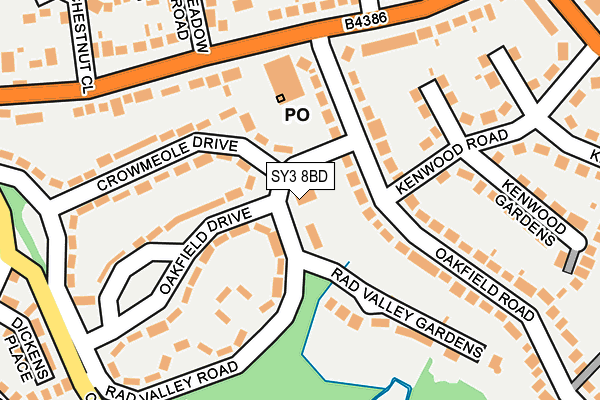
SY3 8BD is located in the Radbrook electoral ward, within the unitary authority of Shropshire and the English Parliamentary constituency of Shrewsbury and Atcham. The Sub Integrated Care Board (ICB) Location is NHS Shropshire, Telford and Wrekin ICB - M2L0M and the police force is West Mercia. This postcode has been in use since January 1993.


GetTheData
Source: OS OpenMap – Local (Ordnance Survey)
Source: OS VectorMap District (Ordnance Survey)
Licence: Open Government Licence (requires attribution)
| Easting | 347200 |
| Northing | 312319 |
| Latitude | 52.705950 |
| Longitude | -2.782885 |
GetTheData
Source: Open Postcode Geo
Licence: Open Government Licence
| Country | England |
| Postcode District | SY3 |
| ➜ SY3 open data dashboard ➜ See where SY3 is on a map ➜ Where is Shrewsbury? | |
GetTheData
Source: Land Registry Price Paid Data
Licence: Open Government Licence
Elevation or altitude of SY3 8BD as distance above sea level:
| Metres | Feet | |
|---|---|---|
| Elevation | 70m | 230ft |
Elevation is measured from the approximate centre of the postcode, to the nearest point on an OS contour line from OS Terrain 50, which has contour spacing of ten vertical metres.
➜ How high above sea level am I? Find the elevation of your current position using your device's GPS.
GetTheData
Source: Open Postcode Elevation
Licence: Open Government Licence
| Ward | Radbrook |
| Constituency | Shrewsbury And Atcham |
GetTheData
Source: ONS Postcode Database
Licence: Open Government Licence
| January 2024 | Violence and sexual offences | On or near Cruckton Close | 489m |
| December 2023 | Other theft | On or near Ryelands | 418m |
| December 2023 | Anti-social behaviour | On or near Westlands Road | 441m |
| ➜ Get more crime data in our Crime section | |||
GetTheData
Source: data.police.uk
Licence: Open Government Licence
| Oakfield Drive | Copthorne | 170m |
| Oakfield Road Jct (Mytton Oak Road) | Copthorne | 172m |
| Oakfield Drive | Copthorne | 173m |
| Mytton Grove Jct (Mytton Oak Road) | Copthorne | 189m |
| Radbrook Valley Rd Jct (Crowmeole Lane) | Copthorne | 296m |
| Shrewsbury Station | 2.3km |
GetTheData
Source: NaPTAN
Licence: Open Government Licence
GetTheData
Source: ONS Postcode Database
Licence: Open Government Licence


➜ Get more ratings from the Food Standards Agency
GetTheData
Source: Food Standards Agency
Licence: FSA terms & conditions
| Last Collection | |||
|---|---|---|---|
| Location | Mon-Fri | Sat | Distance |
| Copthorne Post Office | 19:00 | 11:30 | 163m |
| Churchill Drive | 19:00 | 11:45 | 286m |
| Crowmeole Lane | 19:15 | 11:45 | 358m |
GetTheData
Source: Dracos
Licence: Creative Commons Attribution-ShareAlike
| Facility | Distance |
|---|---|
| Shorncliffe Drive Recreation Ground Shorncliffe Way, Shrewsbury Grass Pitches | 390m |
| Radbrook Elite Health & Leisure Club (Closed) Radbrook Road, Shrewsbury Studio, Health and Fitness Gym, Swimming Pool, Squash Courts | 399m |
| Radbrook Recreation Ground Radbrook Road, Shrewsbury Grass Pitches | 409m |
GetTheData
Source: Active Places
Licence: Open Government Licence
| School | Phase of Education | Distance |
|---|---|---|
| Woodfield Infant School Woodfield Road, Copthorne, Shrewsbury, SY3 8LU | Primary | 645m |
| St George's Junior School Woodfield Road, Shrewsbury, SY3 8LU | Primary | 671m |
| The Keystone Academy Squinter Pip Way, Shrewsbury, SY5 8PY | Not applicable | 738m |
GetTheData
Source: Edubase
Licence: Open Government Licence
The below table lists the International Territorial Level (ITL) codes (formerly Nomenclature of Territorial Units for Statistics (NUTS) codes) and Local Administrative Units (LAU) codes for SY3 8BD:
| ITL 1 Code | Name |
|---|---|
| TLG | West Midlands (England) |
| ITL 2 Code | Name |
| TLG2 | Shropshire and Staffordshire |
| ITL 3 Code | Name |
| TLG22 | Shropshire |
| LAU 1 Code | Name |
| E06000051 | Shropshire |
GetTheData
Source: ONS Postcode Directory
Licence: Open Government Licence
The below table lists the Census Output Area (OA), Lower Layer Super Output Area (LSOA), and Middle Layer Super Output Area (MSOA) for SY3 8BD:
| Code | Name | |
|---|---|---|
| OA | E00147435 | |
| LSOA | E01028951 | Shropshire 020D |
| MSOA | E02006034 | Shropshire 020 |
GetTheData
Source: ONS Postcode Directory
Licence: Open Government Licence
| SY3 8AL | Oakfield Road | 59m |
| SY3 8AN | Oakfield Road | 124m |
| SY3 8AR | Oakfield Drive | 136m |
| SY3 8AP | Crowmeole Drive | 137m |
| SY3 8UG | Mytton Oak Road | 137m |
| SY3 8AT | Rad Valley Road | 140m |
| SY3 8AF | Kenwood Road | 141m |
| SY3 8AS | Oakfield Drive | 144m |
| SY3 8AW | Crowmeole Drive | 149m |
| SY3 8AU | Rad Valley Gardens | 168m |
GetTheData
Source: Open Postcode Geo; Land Registry Price Paid Data
Licence: Open Government Licence