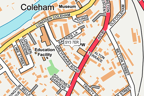
SY3 7ER lies on Greyfriars Road in Shrewsbury. SY3 7ER is located in the Belle Vue electoral ward, within the unitary authority of Shropshire and the English Parliamentary constituency of Shrewsbury and Atcham. The Sub Integrated Care Board (ICB) Location is NHS Shropshire, Telford and Wrekin ICB - M2L0M and the police force is West Mercia. This postcode has been in use since January 1980.


GetTheData
Source: OS OpenMap – Local (Ordnance Survey)
Source: OS VectorMap District (Ordnance Survey)
Licence: Open Government Licence (requires attribution)
| Easting | 349613 |
| Northing | 311965 |
| Latitude | 52.703013 |
| Longitude | -2.747120 |
GetTheData
Source: Open Postcode Geo
Licence: Open Government Licence
| Street | Greyfriars Road |
| Town/City | Shrewsbury |
| Country | England |
| Postcode District | SY3 |
| ➜ SY3 open data dashboard ➜ See where SY3 is on a map ➜ Where is Shrewsbury? | |
GetTheData
Source: Land Registry Price Paid Data
Licence: Open Government Licence
Elevation or altitude of SY3 7ER as distance above sea level:
| Metres | Feet | |
|---|---|---|
| Elevation | 60m | 197ft |
Elevation is measured from the approximate centre of the postcode, to the nearest point on an OS contour line from OS Terrain 50, which has contour spacing of ten vertical metres.
➜ How high above sea level am I? Find the elevation of your current position using your device's GPS.
GetTheData
Source: Open Postcode Elevation
Licence: Open Government Licence
| Ward | Belle Vue |
| Constituency | Shrewsbury And Atcham |
GetTheData
Source: ONS Postcode Database
Licence: Open Government Licence
| December 2023 | Violence and sexual offences | On or near Spa Street | 457m |
| August 2023 | Public order | On or near West Hermitage | 434m |
| June 2023 | Anti-social behaviour | On or near Parking Area | 443m |
| ➜ Greyfriars Road crime map and outcomes | |||
GetTheData
Source: data.police.uk
Licence: Open Government Licence
| The Limes (Belle Vue Road) | Belle Vue | 114m |
| Boars Head Ph (Belle Vue Road) | Coleham | 139m |
| Greyfriars Road Jct (Coleham) | Coleham | 142m |
| The Limes (Belle Vue Road) | Belle Vue | 149m |
| Betton Street Jct (Belle Vue Road) | Coleham | 151m |
| Shrewsbury Station | 1km |
GetTheData
Source: NaPTAN
Licence: Open Government Licence
| Percentage of properties with Next Generation Access | 100.0% |
| Percentage of properties with Superfast Broadband | 100.0% |
| Percentage of properties with Ultrafast Broadband | 100.0% |
| Percentage of properties with Full Fibre Broadband | 0.0% |
Superfast Broadband is between 30Mbps and 300Mbps
Ultrafast Broadband is > 300Mbps
| Percentage of properties unable to receive 2Mbps | 0.0% |
| Percentage of properties unable to receive 5Mbps | 0.0% |
| Percentage of properties unable to receive 10Mbps | 0.0% |
| Percentage of properties unable to receive 30Mbps | 0.0% |
GetTheData
Source: Ofcom
Licence: Ofcom Terms of Use (requires attribution)
GetTheData
Source: ONS Postcode Database
Licence: Open Government Licence


➜ Get more ratings from the Food Standards Agency
GetTheData
Source: Food Standards Agency
Licence: FSA terms & conditions
| Last Collection | |||
|---|---|---|---|
| Location | Mon-Fri | Sat | Distance |
| Greyfriars Bridge | 19:30 | 12:15 | 190m |
| Moreton Crescent | 18:30 | 11:00 | 234m |
| Trinity Street | 18:30 | 11:00 | 279m |
GetTheData
Source: Dracos
Licence: Creative Commons Attribution-ShareAlike
| Facility | Distance |
|---|---|
| Raby Crescent Recreation Ground Raby Crescent, Shrewsbury Grass Pitches | 469m |
| The Wakeman School & Arts College (Closed) Abbey Foregate, Shrewsbury Grass Pitches, Sports Hall | 511m |
| Town Walls Tennis Club Crescent Lane, Shrewsbury Outdoor Tennis Courts | 518m |
GetTheData
Source: Active Places
Licence: Open Government Licence
| School | Phase of Education | Distance |
|---|---|---|
| Coleham Primary School Greyfriars Road, Shrewsbury, SY3 7EN | Primary | 93m |
| St Winefride's Convent School Belmont, Shrewsbury, SY1 1TE | Not applicable | 572m |
| Shrewsbury High School 32 Town Walls, Shrewsbury, Shropshire, SY1 1TN | Not applicable | 739m |
GetTheData
Source: Edubase
Licence: Open Government Licence
The below table lists the International Territorial Level (ITL) codes (formerly Nomenclature of Territorial Units for Statistics (NUTS) codes) and Local Administrative Units (LAU) codes for SY3 7ER:
| ITL 1 Code | Name |
|---|---|
| TLG | West Midlands (England) |
| ITL 2 Code | Name |
| TLG2 | Shropshire and Staffordshire |
| ITL 3 Code | Name |
| TLG22 | Shropshire |
| LAU 1 Code | Name |
| E06000051 | Shropshire |
GetTheData
Source: ONS Postcode Directory
Licence: Open Government Licence
The below table lists the Census Output Area (OA), Lower Layer Super Output Area (LSOA), and Middle Layer Super Output Area (MSOA) for SY3 7ER:
| Code | Name | |
|---|---|---|
| OA | E00147351 | |
| LSOA | E01028938 | Shropshire 022A |
| MSOA | E02006036 | Shropshire 022 |
GetTheData
Source: ONS Postcode Directory
Licence: Open Government Licence
| SY3 7EW | Lorne Terrace | 22m |
| SY3 7EP | Greyfriars Road | 37m |
| SY3 7DR | Trinity Place | 50m |
| SY3 7DJ | School Lane | 56m |
| SY3 7LL | Belle Vue Road | 80m |
| SY3 7DG | Salters Lane | 93m |
| SY3 7LN | Belle Vue Road | 95m |
| SY3 7EN | Greyfriars Road | 97m |
| SY3 7ES | Pound Close | 106m |
| SY3 7DQ | Longden Coleham | 115m |
GetTheData
Source: Open Postcode Geo; Land Registry Price Paid Data
Licence: Open Government Licence