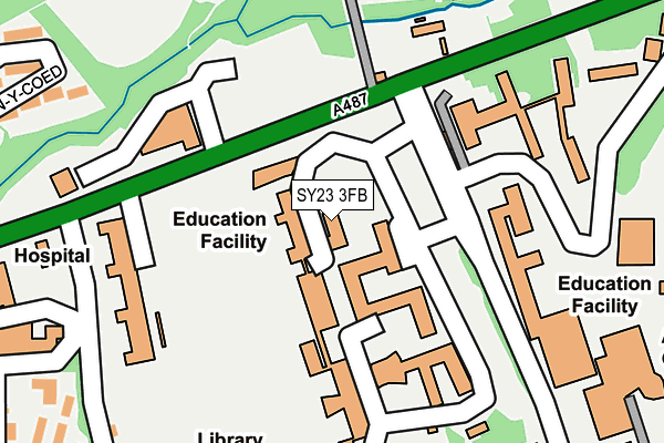
SY23 3FB is located in the Aberystwyth Morfa a Glais electoral ward, within the unitary authority of Ceredigion and the Welsh Parliamentary constituency of Ceredigion. The Local Health Board is Hywel Dda University and the police force is Dyfed-Powys. This postcode has been in use since January 2009.


GetTheData
Source: OS OpenMap – Local (Ordnance Survey)
Source: OS VectorMap District (Ordnance Survey)
Licence: Open Government Licence (requires attribution)
| Easting | 259540 |
| Northing | 281908 |
| Latitude | 52.417079 |
| Longitude | -4.066743 |
GetTheData
Source: Open Postcode Geo
Licence: Open Government Licence
| Country | Wales |
| Postcode District | SY23 |
| ➜ SY23 open data dashboard ➜ See where SY23 is on a map ➜ Where is Aberystwyth? | |
GetTheData
Source: Land Registry Price Paid Data
Licence: Open Government Licence
Elevation or altitude of SY23 3FB as distance above sea level:
| Metres | Feet | |
|---|---|---|
| Elevation | 60m | 197ft |
Elevation is measured from the approximate centre of the postcode, to the nearest point on an OS contour line from OS Terrain 50, which has contour spacing of ten vertical metres.
➜ How high above sea level am I? Find the elevation of your current position using your device's GPS.
GetTheData
Source: Open Postcode Elevation
Licence: Open Government Licence
| Ward | Aberystwyth Morfa A Glais |
| Constituency | Ceredigion |
GetTheData
Source: ONS Postcode Database
Licence: Open Government Licence
| December 2023 | Criminal damage and arson | On or near Hospital | 349m |
| December 2023 | Violence and sexual offences | On or near Hospital | 349m |
| November 2023 | Violence and sexual offences | On or near Hospital | 349m |
| ➜ Get more crime data in our Crime section | |||
GetTheData
Source: data.police.uk
Licence: Open Government Licence
| National Library (Penglais Road) | Penglais | 91m |
| University Campus Penglais (Grounds) | Penglais | 96m |
| National Library (Penglais Road) | Penglais | 109m |
| Bronglais Hospital (Caradoc Road) | Aberystwyth | 335m |
| National Library (Grounds) | Llain-y-gawsai | 364m |
| Llanbadarn (Vale Of Rheidol Railway) | Llanbadarn Fawr | 1,254m |
| Aberystwyth Station | 1.1km |
GetTheData
Source: NaPTAN
Licence: Open Government Licence
GetTheData
Source: ONS Postcode Database
Licence: Open Government Licence


➜ Get more ratings from the Food Standards Agency
GetTheData
Source: Food Standards Agency
Licence: FSA terms & conditions
| Last Collection | |||
|---|---|---|---|
| Location | Mon-Fri | Sat | Distance |
| Penglais Campus | 17:30 | 11:45 | 124m |
| Penglais Park | 17:00 | 11:45 | 249m |
| University Village | 17:00 | 11:45 | 440m |
GetTheData
Source: Dracos
Licence: Creative Commons Attribution-ShareAlike
| School | Phase of Education | Distance |
|---|---|---|
| Ysgol Penglais Waunfawr, Aberystwyth, Ceredigion, SY23 3AW | Not applicable | 521m |
| Ysgol Padarn Sant Llanbadarn Road, Aberystwyth, Ceredigion, SY23 1EZ | Not applicable | 664m |
| Yr Ysgol Gymraeg Plascrug Avenue, Aberystwyth, Ceredigion, SY23 1HL | Not applicable | 813m |
GetTheData
Source: Edubase
Licence: Open Government Licence
The below table lists the International Territorial Level (ITL) codes (formerly Nomenclature of Territorial Units for Statistics (NUTS) codes) and Local Administrative Units (LAU) codes for SY23 3FB:
| ITL 1 Code | Name |
|---|---|
| TLL | Wales |
| ITL 2 Code | Name |
| TLL1 | West Wales and The Valleys |
| ITL 3 Code | Name |
| TLL14 | South West Wales |
| LAU 1 Code | Name |
| W06000008 | Ceredigion |
GetTheData
Source: ONS Postcode Directory
Licence: Open Government Licence
The below table lists the Census Output Area (OA), Lower Layer Super Output Area (LSOA), and Middle Layer Super Output Area (MSOA) for SY23 3FB:
| Code | Name | |
|---|---|---|
| OA | W00010054 | |
| LSOA | W01000512 | Ceredigion 002A |
| MSOA | W02000117 | Ceredigion 002 |
GetTheData
Source: ONS Postcode Directory
Licence: Open Government Licence
| SY23 2HD | Danycoed | 355m |
| SY23 1ES | Caradoc Road | 356m |
| SY23 1ET | Caergog | 383m |
| SY23 1ED | Bryn Ardwyn | 404m |
| SY23 2HB | Plas Danycoed | 409m |
| SY23 1EP | Caergog Terrace | 416m |
| SY23 1EE | Bryn Ardwyn | 465m |
| SY23 2LB | Caradoc Road | 481m |
| SY23 3QB | Cefnllan Road | 483m |
| SY23 1EW | Iorwerth Avenue | 504m |
GetTheData
Source: Open Postcode Geo; Land Registry Price Paid Data
Licence: Open Government Licence