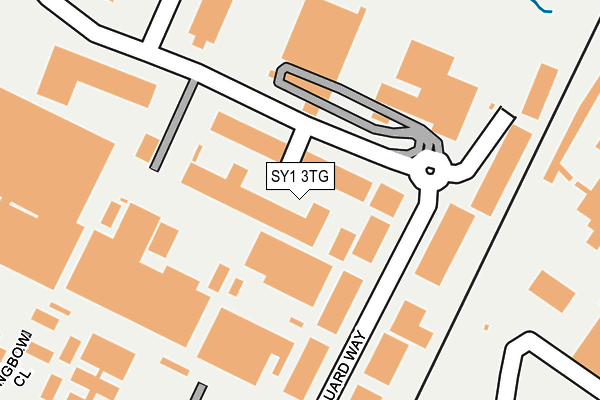
SY1 3TG lies on Vanguard Way in Battlefield Enterprise Park, Shrewsbury. SY1 3TG is located in the Harlescott electoral ward, within the unitary authority of Shropshire and the English Parliamentary constituency of Shrewsbury and Atcham. The Sub Integrated Care Board (ICB) Location is NHS Shropshire, Telford and Wrekin ICB - M2L0M and the police force is West Mercia. This postcode has been in use since June 2004.


GetTheData
Source: OS OpenMap – Local (Ordnance Survey)
Source: OS VectorMap District (Ordnance Survey)
Licence: Open Government Licence (requires attribution)
| Easting | 350903 |
| Northing | 316235 |
| Latitude | 52.741515 |
| Longitude | -2.728670 |
GetTheData
Source: Open Postcode Geo
Licence: Open Government Licence
| Street | Vanguard Way |
| Locality | Battlefield Enterprise Park |
| Town/City | Shrewsbury |
| Country | England |
| Postcode District | SY1 |
| ➜ SY1 open data dashboard ➜ See where SY1 is on a map ➜ Where is Shrewsbury? | |
GetTheData
Source: Land Registry Price Paid Data
Licence: Open Government Licence
Elevation or altitude of SY1 3TG as distance above sea level:
| Metres | Feet | |
|---|---|---|
| Elevation | 70m | 230ft |
Elevation is measured from the approximate centre of the postcode, to the nearest point on an OS contour line from OS Terrain 50, which has contour spacing of ten vertical metres.
➜ How high above sea level am I? Find the elevation of your current position using your device's GPS.
GetTheData
Source: Open Postcode Elevation
Licence: Open Government Licence
| Ward | Harlescott |
| Constituency | Shrewsbury And Atcham |
GetTheData
Source: ONS Postcode Database
Licence: Open Government Licence
| June 2022 | Public order | On or near Petrol Station | 378m |
| June 2022 | Shoplifting | On or near Petrol Station | 378m |
| June 2022 | Shoplifting | On or near Petrol Station | 378m |
| ➜ Vanguard Way crime map and outcomes | |||
GetTheData
Source: data.police.uk
Licence: Open Government Licence
| Harlescott P&r (Car Park) | Harlescott | 311m |
| Harlescott Lane Jct (Lancaster Road) | Harlescott Grange | 365m |
| Harlescott Lane Jct (Lancaster Road) | Harlescott Grange | 369m |
| Tesco (Tesco Extra) | Harlescott | 378m |
| Ford Garage (Battlefield Way) | Battlefield | 405m |
| Shrewsbury Station | 3.6km |
GetTheData
Source: NaPTAN
Licence: Open Government Licence
| Median download speed | 77.9Mbps |
| Average download speed | 58.3Mbps |
| Maximum download speed | 80.00Mbps |
| Median upload speed | 20.0Mbps |
| Average upload speed | 14.4Mbps |
| Maximum upload speed | 20.00Mbps |
GetTheData
Source: Ofcom
Licence: Ofcom Terms of Use (requires attribution)
Estimated total energy consumption in SY1 3TG by fuel type, 2015.
| Consumption (kWh) | 578,078 |
|---|---|
| Meter count | 26 |
| Mean (kWh/meter) | 22,234 |
| Median (kWh/meter) | 14,790 |
GetTheData
Source: Postcode level gas estimates: 2015 (experimental)
Source: Postcode level electricity estimates: 2015 (experimental)
Licence: Open Government Licence
GetTheData
Source: ONS Postcode Database
Licence: Open Government Licence


➜ Get more ratings from the Food Standards Agency
GetTheData
Source: Food Standards Agency
Licence: FSA terms & conditions
| Last Collection | |||
|---|---|---|---|
| Location | Mon-Fri | Sat | Distance |
| Lancaster Road North | 19:00 | 11:30 | 351m |
| Battlefield Enterprise Park | 18:45 | 605m | |
| Battlefield Enterprise Park | 18:45 | 11:30 | 608m |
GetTheData
Source: Dracos
Licence: Creative Commons Attribution-ShareAlike
| Facility | Distance |
|---|---|
| Kynaston Road Recreation Ground Kynaston Road, Shrewsbury Grass Pitches | 684m |
| Simply Gym Shrewsbury (Closed) Henley Way, Shrewsbury Health and Fitness Gym, Studio | 701m |
| Muscle Mania Gym & Fitness (Closed) Lancaster Road, Shrewsbury Health and Fitness Gym, Studio | 875m |
GetTheData
Source: Active Places
Licence: Open Government Licence
| School | Phase of Education | Distance |
|---|---|---|
| Greenacres Primary School Rutland, Off York Road, Harlescott Grange, Shrewsbury, SY1 3QG | Primary | 670m |
| Harlescott House School Harlescott House Lane, Shrewsbury, Shropshire, SY1 3BA | Not applicable | 803m |
| Grange Primary School Bainbridge Green, Harlescott, Shrewsbury, SY1 3QR | Primary | 1.1km |
GetTheData
Source: Edubase
Licence: Open Government Licence
The below table lists the International Territorial Level (ITL) codes (formerly Nomenclature of Territorial Units for Statistics (NUTS) codes) and Local Administrative Units (LAU) codes for SY1 3TG:
| ITL 1 Code | Name |
|---|---|
| TLG | West Midlands (England) |
| ITL 2 Code | Name |
| TLG2 | Shropshire and Staffordshire |
| ITL 3 Code | Name |
| TLG22 | Shropshire |
| LAU 1 Code | Name |
| E06000051 | Shropshire |
GetTheData
Source: ONS Postcode Directory
Licence: Open Government Licence
The below table lists the Census Output Area (OA), Lower Layer Super Output Area (LSOA), and Middle Layer Super Output Area (MSOA) for SY1 3TG:
| Code | Name | |
|---|---|---|
| OA | E00147460 | |
| LSOA | E01028958 | Shropshire 015E |
| MSOA | E02006029 | Shropshire 015 |
GetTheData
Source: ONS Postcode Directory
Licence: Open Government Licence
| SY1 3AN | Harlescott Crossing | 372m |
| SY1 3AR | Harlescott Lane | 413m |
| SY1 3JG | Lancaster Road | 434m |
| SY1 3JQ | Aynesworth Green | 445m |
| SY1 3AX | Harlescott Crescent | 465m |
| SY1 3AU | Harlescott Crescent | 468m |
| SY1 3JB | Freshfields | 505m |
| SY1 3JH | Kynaston Road | 521m |
| SY1 3AH | Harlescott Lane | 523m |
| SY1 3JL | Beaufort Green | 531m |
GetTheData
Source: Open Postcode Geo; Land Registry Price Paid Data
Licence: Open Government Licence