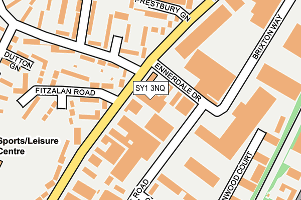
SY1 3NQ is located in the Harlescott electoral ward, within the unitary authority of Shropshire and the English Parliamentary constituency of Shrewsbury and Atcham. The Sub Integrated Care Board (ICB) Location is NHS Shropshire, Telford and Wrekin ICB - M2L0M and the police force is West Mercia. This postcode has been in use since January 1980.


GetTheData
Source: OS OpenMap – Local (Ordnance Survey)
Source: OS VectorMap District (Ordnance Survey)
Licence: Open Government Licence (requires attribution)
| Easting | 350474 |
| Northing | 315584 |
| Latitude | 52.735609 |
| Longitude | -2.734928 |
GetTheData
Source: Open Postcode Geo
Licence: Open Government Licence
| Country | England |
| Postcode District | SY1 |
| ➜ SY1 open data dashboard ➜ See where SY1 is on a map ➜ Where is Shrewsbury? | |
GetTheData
Source: Land Registry Price Paid Data
Licence: Open Government Licence
Elevation or altitude of SY1 3NQ as distance above sea level:
| Metres | Feet | |
|---|---|---|
| Elevation | 70m | 230ft |
Elevation is measured from the approximate centre of the postcode, to the nearest point on an OS contour line from OS Terrain 50, which has contour spacing of ten vertical metres.
➜ How high above sea level am I? Find the elevation of your current position using your device's GPS.
GetTheData
Source: Open Postcode Elevation
Licence: Open Government Licence
| Ward | Harlescott |
| Constituency | Shrewsbury And Atcham |
GetTheData
Source: ONS Postcode Database
Licence: Open Government Licence
| December 2023 | Criminal damage and arson | On or near York Road | 435m |
| December 2023 | Violence and sexual offences | On or near York Road | 435m |
| November 2023 | Violence and sexual offences | On or near York Road | 435m |
| ➜ Get more crime data in our Crime section | |||
GetTheData
Source: data.police.uk
Licence: Open Government Licence
| Lancaster Road Jct (York Road) | Harlescott Grange | 86m |
| Ennerdale Road Jct (Ennerdale Drive) | Harlescott Grange | 98m |
| Grosvenor Green Jct (York Road) | Harlescott Grange | 166m |
| Prestbury Green Jct (Lancaster Road) | Harlescott Grange | 170m |
| Prestbury Green Jct (Lancaster Road) | Harlescott Grange | 187m |
| Shrewsbury Station | 2.8km |
GetTheData
Source: NaPTAN
Licence: Open Government Licence
GetTheData
Source: ONS Postcode Database
Licence: Open Government Licence


➜ Get more ratings from the Food Standards Agency
GetTheData
Source: Food Standards Agency
Licence: FSA terms & conditions
| Last Collection | |||
|---|---|---|---|
| Location | Mon-Fri | Sat | Distance |
| York Road South | 19:15 | 12:00 | 316m |
| Levens Drive Meter Box | 18:45 | 327m | |
| Levens Drive | 18:45 | 11:45 | 327m |
GetTheData
Source: Dracos
Licence: Creative Commons Attribution-ShareAlike
| Facility | Distance |
|---|---|
| Muscle Mania Gym & Fitness (Closed) Lancaster Road, Shrewsbury Health and Fitness Gym, Studio | 96m |
| Grange Sports Centre (Shrewsbury) Worcester Road, Shrewsbury Sports Hall, Grass Pitches, Artificial Grass Pitch, Health and Fitness Gym | 341m |
| Kynaston Road Recreation Ground Kynaston Road, Shrewsbury Grass Pitches | 374m |
GetTheData
Source: Active Places
Licence: Open Government Licence
| School | Phase of Education | Distance |
|---|---|---|
| Grange Primary School Bainbridge Green, Harlescott, Shrewsbury, SY1 3QR | Primary | 482m |
| Greenacres Primary School Rutland, Off York Road, Harlescott Grange, Shrewsbury, SY1 3QG | Primary | 655m |
| Shrewsbury Academy Corndon Crescent, Shrewsbury, SY1 4LL | Secondary | 886m |
GetTheData
Source: Edubase
Licence: Open Government Licence
The below table lists the International Territorial Level (ITL) codes (formerly Nomenclature of Territorial Units for Statistics (NUTS) codes) and Local Administrative Units (LAU) codes for SY1 3NQ:
| ITL 1 Code | Name |
|---|---|
| TLG | West Midlands (England) |
| ITL 2 Code | Name |
| TLG2 | Shropshire and Staffordshire |
| ITL 3 Code | Name |
| TLG22 | Shropshire |
| LAU 1 Code | Name |
| E06000051 | Shropshire |
GetTheData
Source: ONS Postcode Directory
Licence: Open Government Licence
The below table lists the Census Output Area (OA), Lower Layer Super Output Area (LSOA), and Middle Layer Super Output Area (MSOA) for SY1 3NQ:
| Code | Name | |
|---|---|---|
| OA | E00147453 | |
| LSOA | E01028956 | Shropshire 015C |
| MSOA | E02006029 | Shropshire 015 |
GetTheData
Source: ONS Postcode Directory
Licence: Open Government Licence
| SY1 3LQ | Lancaster Road | 73m |
| SY1 3RE | York Road | 118m |
| SY1 3RD | York Road | 128m |
| SY1 3LA | Lancaster Road | 138m |
| SY1 3LH | Fitzalan Road | 151m |
| SY1 3LJ | Fitzalan Road | 158m |
| SY1 3RF | Grosvenor Green | 170m |
| SY1 3JX | Prestbury Green | 183m |
| SY1 3JY | Prestbury Green | 206m |
| SY1 3LG | Lancaster Road | 220m |
GetTheData
Source: Open Postcode Geo; Land Registry Price Paid Data
Licence: Open Government Licence