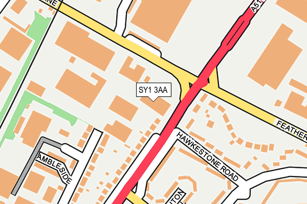
SY1 3AA is located in the Battlefield electoral ward, within the unitary authority of Shropshire and the English Parliamentary constituency of Shrewsbury and Atcham. The Sub Integrated Care Board (ICB) Location is NHS Shropshire, Telford and Wrekin ICB - M2L0M and the police force is West Mercia. This postcode has been in use since January 1980.


GetTheData
Source: OS OpenMap – Local (Ordnance Survey)
Source: OS VectorMap District (Ordnance Survey)
Licence: Open Government Licence (requires attribution)
| Easting | 351091 |
| Northing | 315651 |
| Latitude | 52.736283 |
| Longitude | -2.725798 |
GetTheData
Source: Open Postcode Geo
Licence: Open Government Licence
| Country | England |
| Postcode District | SY1 |
| ➜ SY1 open data dashboard ➜ See where SY1 is on a map ➜ Where is Shrewsbury? | |
GetTheData
Source: Land Registry Price Paid Data
Licence: Open Government Licence
Elevation or altitude of SY1 3AA as distance above sea level:
| Metres | Feet | |
|---|---|---|
| Elevation | 70m | 230ft |
Elevation is measured from the approximate centre of the postcode, to the nearest point on an OS contour line from OS Terrain 50, which has contour spacing of ten vertical metres.
➜ How high above sea level am I? Find the elevation of your current position using your device's GPS.
GetTheData
Source: Open Postcode Elevation
Licence: Open Government Licence
| Ward | Battlefield |
| Constituency | Shrewsbury And Atcham |
GetTheData
Source: ONS Postcode Database
Licence: Open Government Licence
| June 2022 | Shoplifting | On or near Whitchurch Road | 113m |
| June 2022 | Violence and sexual offences | On or near Harlescott Lane | 120m |
| June 2022 | Criminal damage and arson | On or near Harlescott Lane | 120m |
| ➜ Get more crime data in our Crime section | |||
GetTheData
Source: data.police.uk
Licence: Open Government Licence
| Hawkstone Road Jct (Whitchurch Road) | Harlescott | 49m |
| Hawkstone Road Jct (Whitchurch Road) | Harlescott | 62m |
| B & Q (Featherbed Lane) | Sundorne | 128m |
| Rail Crossing (Harlescott Lane) | Harlescott | 159m |
| B & Q (Featherbed Lane) | Sundorne | 185m |
| Shrewsbury Station | 3.2km |
GetTheData
Source: NaPTAN
Licence: Open Government Licence
GetTheData
Source: ONS Postcode Database
Licence: Open Government Licence


➜ Get more ratings from the Food Standards Agency
GetTheData
Source: Food Standards Agency
Licence: FSA terms & conditions
| Last Collection | |||
|---|---|---|---|
| Location | Mon-Fri | Sat | Distance |
| Whitchurch Road | 18:45 | 11:15 | 176m |
| Lancaster Road North | 19:00 | 11:30 | 447m |
| Arlington Way | 19:00 | 11:15 | 562m |
GetTheData
Source: Dracos
Licence: Creative Commons Attribution-ShareAlike
| Facility | Distance |
|---|---|
| Simply Gym Shrewsbury (Closed) Henley Way, Shrewsbury Health and Fitness Gym, Studio | 373m |
| Shrewsbury Academy Corndon Crescent, Shrewsbury Sports Hall, Grass Pitches, Studio, Health and Fitness Gym, Outdoor Tennis Courts | 538m |
| Jd Gyms (Shrewsbury) Arlington Way, Shrewsbury Health and Fitness Gym, Studio | 626m |
GetTheData
Source: Active Places
Licence: Open Government Licence
| School | Phase of Education | Distance |
|---|---|---|
| Shrewsbury Academy Corndon Crescent, Shrewsbury, SY1 4LL | Secondary | 538m |
| Sundorne Infant School and Nursery Featherbed Lane, Shrewsbury, SY1 4QN | Primary | 668m |
| Harlescott Junior School Featherbed Lane, Shrewsbury, SY1 4QN | Primary | 753m |
GetTheData
Source: Edubase
Licence: Open Government Licence
The below table lists the International Territorial Level (ITL) codes (formerly Nomenclature of Territorial Units for Statistics (NUTS) codes) and Local Administrative Units (LAU) codes for SY1 3AA:
| ITL 1 Code | Name |
|---|---|
| TLG | West Midlands (England) |
| ITL 2 Code | Name |
| TLG2 | Shropshire and Staffordshire |
| ITL 3 Code | Name |
| TLG22 | Shropshire |
| LAU 1 Code | Name |
| E06000051 | Shropshire |
GetTheData
Source: ONS Postcode Directory
Licence: Open Government Licence
The below table lists the Census Output Area (OA), Lower Layer Super Output Area (LSOA), and Middle Layer Super Output Area (MSOA) for SY1 3AA:
| Code | Name | |
|---|---|---|
| OA | E00147325 | |
| LSOA | E01028932 | Shropshire 016A |
| MSOA | E02006030 | Shropshire 016 |
GetTheData
Source: ONS Postcode Directory
Licence: Open Government Licence
| SY1 4HA | Whitchurch Road | 85m |
| SY1 3AH | Harlescott Lane | 94m |
| SY1 4EY | Whitchurch Road | 95m |
| SY1 4EZ | Whitchurch Road | 128m |
| SY1 4NX | Hawkestone Road | 156m |
| SY1 4NY | Hawkestone Road | 157m |
| SY1 4ES | Kendal Road | 173m |
| SY1 4LY | Dounton Close | 199m |
| SY1 4NN | Featherbed Lane | 200m |
| SY1 4LX | Meadow Farm Drive | 229m |
GetTheData
Source: Open Postcode Geo; Land Registry Price Paid Data
Licence: Open Government Licence