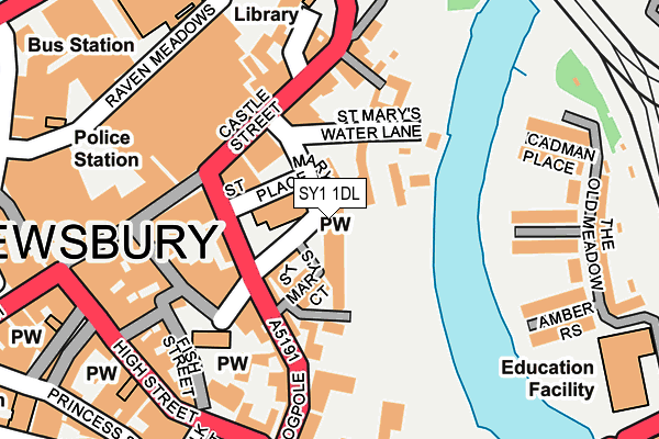
SY1 1DL is located in the Quarry and Coton Hill electoral ward, within the unitary authority of Shropshire and the English Parliamentary constituency of Shrewsbury and Atcham. The Sub Integrated Care Board (ICB) Location is NHS Shropshire, Telford and Wrekin ICB - M2L0M and the police force is West Mercia. This postcode has been in use since July 1983.


GetTheData
Source: OS OpenMap – Local (Ordnance Survey)
Source: OS VectorMap District (Ordnance Survey)
Licence: Open Government Licence (requires attribution)
| Easting | 349379 |
| Northing | 312592 |
| Latitude | 52.708613 |
| Longitude | -2.750681 |
GetTheData
Source: Open Postcode Geo
Licence: Open Government Licence
| Country | England |
| Postcode District | SY1 |
| ➜ SY1 open data dashboard ➜ See where SY1 is on a map ➜ Where is Shrewsbury? | |
GetTheData
Source: Land Registry Price Paid Data
Licence: Open Government Licence
Elevation or altitude of SY1 1DL as distance above sea level:
| Metres | Feet | |
|---|---|---|
| Elevation | 60m | 197ft |
Elevation is measured from the approximate centre of the postcode, to the nearest point on an OS contour line from OS Terrain 50, which has contour spacing of ten vertical metres.
➜ How high above sea level am I? Find the elevation of your current position using your device's GPS.
GetTheData
Source: Open Postcode Elevation
Licence: Open Government Licence
| Ward | Quarry And Coton Hill |
| Constituency | Shrewsbury And Atcham |
GetTheData
Source: ONS Postcode Database
Licence: Open Government Licence
| January 2024 | Anti-social behaviour | On or near Swan Hill | 441m |
| January 2024 | Anti-social behaviour | On or near Parking Area | 480m |
| January 2024 | Drugs | On or near Parking Area | 480m |
| ➜ Get more crime data in our Crime section | |||
GetTheData
Source: data.police.uk
Licence: Open Government Licence
| Town Services (St Mary's Street) | Shrewsbury | 83m |
| County Services (St Mary's Street) | Shrewsbury | 83m |
| Castle Street | Shrewsbury | 105m |
| Castle Street | Shrewsbury | 113m |
| Dogpole | Shrewsbury | 155m |
| Shrewsbury Station | 0.4km |
GetTheData
Source: NaPTAN
Licence: Open Government Licence
GetTheData
Source: ONS Postcode Database
Licence: Open Government Licence


➜ Get more ratings from the Food Standards Agency
GetTheData
Source: Food Standards Agency
Licence: FSA terms & conditions
| Last Collection | |||
|---|---|---|---|
| Location | Mon-Fri | Sat | Distance |
| Shrewsbury Post Office | 19:30 | 13:00 | 118m |
| Shrewsbury Post Office | 19:30 | 13:00 | 131m |
| Sy1 St Mary's Street B O, Shrewsbury | 19:30 | 16:15 | 131m |
GetTheData
Source: Dracos
Licence: Creative Commons Attribution-ShareAlike
| Facility | Distance |
|---|---|
| Body Image Health & Fitness (Closed) St. Marys Place, Shrewsbury Health and Fitness Gym | 51m |
| Gay Meadow (Shrewsbury Town Fc) (Closed) Abbey Foregate, Shrewsbury Grass Pitches | 259m |
| The Wakeman School & Arts College (Closed) Abbey Foregate, Shrewsbury Grass Pitches, Sports Hall | 304m |
GetTheData
Source: Active Places
Licence: Open Government Licence
| School | Phase of Education | Distance |
|---|---|---|
| St Winefride's Convent School Belmont, Shrewsbury, SY1 1TE | Not applicable | 357m |
| Shrewsbury High School 32 Town Walls, Shrewsbury, Shropshire, SY1 1TN | Not applicable | 556m |
| Coleham Primary School Greyfriars Road, Shrewsbury, SY3 7EN | Primary | 627m |
GetTheData
Source: Edubase
Licence: Open Government Licence
The below table lists the International Territorial Level (ITL) codes (formerly Nomenclature of Territorial Units for Statistics (NUTS) codes) and Local Administrative Units (LAU) codes for SY1 1DL:
| ITL 1 Code | Name |
|---|---|
| TLG | West Midlands (England) |
| ITL 2 Code | Name |
| TLG2 | Shropshire and Staffordshire |
| ITL 3 Code | Name |
| TLG22 | Shropshire |
| LAU 1 Code | Name |
| E06000051 | Shropshire |
GetTheData
Source: ONS Postcode Directory
Licence: Open Government Licence
The below table lists the Census Output Area (OA), Lower Layer Super Output Area (LSOA), and Middle Layer Super Output Area (MSOA) for SY1 1DL:
| Code | Name | |
|---|---|---|
| OA | E00147396 | |
| LSOA | E01028946 | Shropshire 019A |
| MSOA | E02006033 | Shropshire 019 |
GetTheData
Source: ONS Postcode Directory
Licence: Open Government Licence
| SY1 1DY | St Marys Place | 0m |
| SY1 1DW | St Marys Place | 54m |
| SY1 2BA | St Marys Water Lane | 55m |
| SY1 1EG | St Marys Court | 67m |
| SY1 1DX | St Marys Place | 84m |
| SY1 1EB | St Marys Street | 87m |
| SY1 2BX | St Marys Water Lane | 87m |
| SY1 2BW | Castle Street | 100m |
| SY1 1DF | Newport Place | 103m |
| SY1 1UG | Church Street | 120m |
GetTheData
Source: Open Postcode Geo; Land Registry Price Paid Data
Licence: Open Government Licence