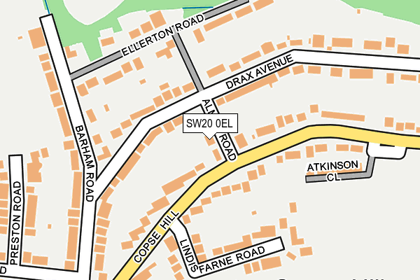
SW20 0EL lies on Almer Road in London. SW20 0EL is located in the Village electoral ward, within the London borough of Merton and the English Parliamentary constituency of Wimbledon. The Sub Integrated Care Board (ICB) Location is NHS South West London ICB - 36L and the police force is Metropolitan Police. This postcode has been in use since January 1980.


GetTheData
Source: OS OpenMap – Local (Ordnance Survey)
Source: OS VectorMap District (Ordnance Survey)
Licence: Open Government Licence (requires attribution)
| Easting | 522273 |
| Northing | 170286 |
| Latitude | 51.418411 |
| Longitude | -0.242959 |
GetTheData
Source: Open Postcode Geo
Licence: Open Government Licence
| Street | Almer Road |
| Town/City | London |
| Country | England |
| Postcode District | SW20 |
➜ See where SW20 is on a map ➜ Where is London? | |
GetTheData
Source: Land Registry Price Paid Data
Licence: Open Government Licence
Elevation or altitude of SW20 0EL as distance above sea level:
| Metres | Feet | |
|---|---|---|
| Elevation | 30m | 98ft |
Elevation is measured from the approximate centre of the postcode, to the nearest point on an OS contour line from OS Terrain 50, which has contour spacing of ten vertical metres.
➜ How high above sea level am I? Find the elevation of your current position using your device's GPS.
GetTheData
Source: Open Postcode Elevation
Licence: Open Government Licence
| Ward | Village |
| Constituency | Wimbledon |
GetTheData
Source: ONS Postcode Database
Licence: Open Government Licence
2016 29 JAN £3,900,000 |
2013 30 APR £3,925,000 |
2010 22 JAN £2,950,000 |
2007 1 OCT £1,725,000 |
1, ALMER ROAD, LONDON, SW20 0EL 2007 28 SEP £2,250,000 |
1, ALMER ROAD, LONDON, SW20 0EL 2004 14 JUL £1,800,000 |
3, ALMER ROAD, LONDON, SW20 0EL 1999 2 SEP £930,000 |
1, ALMER ROAD, LONDON, SW20 0EL 1995 24 MAY £617,500 |
GetTheData
Source: HM Land Registry Price Paid Data
Licence: Contains HM Land Registry data © Crown copyright and database right 2025. This data is licensed under the Open Government Licence v3.0.
| Atkinson Close Copse Hill | Copse Hill | 240m |
| Holland Avenue (Coombe Lane) | Copse Hill | 582m |
| Coombe Lane West (Robin Hood Way) | Coombe | 586m |
| Cottenham Park Road (Coombe Lane) | Cottenham Park | 592m |
| Holland Avenue (Coombe Lane) | Copse Hill | 601m |
| Raynes Park Station | 1.4km |
| New Malden Station | 1.8km |
| Wimbledon Chase Station | 2.2km |
GetTheData
Source: NaPTAN
Licence: Open Government Licence
| Percentage of properties with Next Generation Access | 100.0% |
| Percentage of properties with Superfast Broadband | 100.0% |
| Percentage of properties with Ultrafast Broadband | 0.0% |
| Percentage of properties with Full Fibre Broadband | 0.0% |
Superfast Broadband is between 30Mbps and 300Mbps
Ultrafast Broadband is > 300Mbps
| Percentage of properties unable to receive 2Mbps | 0.0% |
| Percentage of properties unable to receive 5Mbps | 0.0% |
| Percentage of properties unable to receive 10Mbps | 0.0% |
| Percentage of properties unable to receive 30Mbps | 0.0% |
GetTheData
Source: Ofcom
Licence: Ofcom Terms of Use (requires attribution)
GetTheData
Source: ONS Postcode Database
Licence: Open Government Licence


➜ Get more ratings from the Food Standards Agency
GetTheData
Source: Food Standards Agency
Licence: FSA terms & conditions
| Last Collection | |||
|---|---|---|---|
| Location | Mon-Fri | Sat | Distance |
| 34 Drax Avenue | 16:00 | 12:00 | 106m |
| Copse Hill | 16:00 | 12:00 | 288m |
| Copse Hill | 16:00 | 12:00 | 450m |
GetTheData
Source: Dracos
Licence: Creative Commons Attribution-ShareAlike
The below table lists the International Territorial Level (ITL) codes (formerly Nomenclature of Territorial Units for Statistics (NUTS) codes) and Local Administrative Units (LAU) codes for SW20 0EL:
| ITL 1 Code | Name |
|---|---|
| TLI | London |
| ITL 2 Code | Name |
| TLI6 | Outer London - South |
| ITL 3 Code | Name |
| TLI63 | Merton, Kingston upon Thames and Sutton |
| LAU 1 Code | Name |
| E09000024 | Merton |
GetTheData
Source: ONS Postcode Directory
Licence: Open Government Licence
The below table lists the Census Output Area (OA), Lower Layer Super Output Area (LSOA), and Middle Layer Super Output Area (MSOA) for SW20 0EL:
| Code | Name | |
|---|---|---|
| OA | E00017521 | |
| LSOA | E01003463 | Merton 010E |
| MSOA | E02000698 | Merton 010 |
GetTheData
Source: ONS Postcode Directory
Licence: Open Government Licence
| SW20 0NJ | Copse Hill | 81m |
| SW20 0EQ | Drax Avenue | 96m |
| SW20 0EZ | Drax Avenue | 102m |
| SW20 0EY | Drax Avenue | 103m |
| SW20 0NP | Copse Hill | 132m |
| SW20 0NL | Copse Hill | 133m |
| SW20 0EJ | Drax Avenue | 143m |
| SW20 0EN | Almer Road | 151m |
| SW20 0NW | Lindisfarne Road | 156m |
| SW20 0ES | Barham Road | 163m |
GetTheData
Source: Open Postcode Geo; Land Registry Price Paid Data
Licence: Open Government Licence