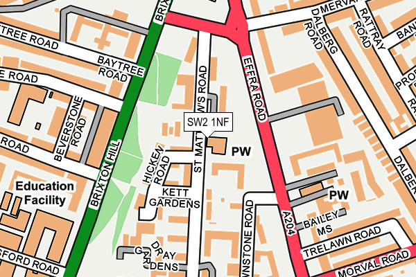
SW2 1NF is located in the Brixton Rush Common electoral ward, within the London borough of Lambeth and the English Parliamentary constituency of Streatham. The Sub Integrated Care Board (ICB) Location is NHS South East London ICB - 72Q and the police force is Metropolitan Police. This postcode has been in use since January 1980.


GetTheData
Source: OS OpenMap – Local (Ordnance Survey)
Source: OS VectorMap District (Ordnance Survey)
Licence: Open Government Licence (requires attribution)
| Easting | 530995 |
| Northing | 174879 |
| Latitude | 51.457741 |
| Longitude | -0.115924 |
GetTheData
Source: Open Postcode Geo
Licence: Open Government Licence
| Country | England |
| Postcode District | SW2 |
| ➜ SW2 open data dashboard ➜ See where SW2 is on a map ➜ Where is London? | |
GetTheData
Source: Land Registry Price Paid Data
Licence: Open Government Licence
Elevation or altitude of SW2 1NF as distance above sea level:
| Metres | Feet | |
|---|---|---|
| Elevation | 20m | 66ft |
Elevation is measured from the approximate centre of the postcode, to the nearest point on an OS contour line from OS Terrain 50, which has contour spacing of ten vertical metres.
➜ How high above sea level am I? Find the elevation of your current position using your device's GPS.
GetTheData
Source: Open Postcode Elevation
Licence: Open Government Licence
| Ward | Brixton Rush Common |
| Constituency | Streatham |
GetTheData
Source: ONS Postcode Database
Licence: Open Government Licence
| January 2024 | Possession of weapons | On or near Dray Gardens | 201m |
| January 2024 | Public order | On or near Dray Gardens | 201m |
| January 2024 | Violence and sexual offences | On or near Further/Higher Educational Building | 288m |
| ➜ Get more crime data in our Crime section | |||
GetTheData
Source: data.police.uk
Licence: Open Government Licence
| St Matthews Estate (Effra Road) | Brixton | 89m |
| St Matthews Estate | Brixton | 92m |
| Rush Common (Brixton Hill) | Brixton | 136m |
| Rush Common (Brixton Hill) | Brixton | 143m |
| Morval Road | Brixton | 164m |
| Brixton Underground Station | Brixton | 547m |
| Clapham North Underground Station | Clapham | 1,279m |
| Brixton Station | 0.6km |
| Herne Hill Station | 1.1km |
| Loughborough Junction Station | 1.3km |
GetTheData
Source: NaPTAN
Licence: Open Government Licence
| Percentage of properties with Next Generation Access | 100.0% |
| Percentage of properties with Superfast Broadband | 100.0% |
| Percentage of properties with Ultrafast Broadband | 0.0% |
| Percentage of properties with Full Fibre Broadband | 0.0% |
Superfast Broadband is between 30Mbps and 300Mbps
Ultrafast Broadband is > 300Mbps
| Percentage of properties unable to receive 2Mbps | 0.0% |
| Percentage of properties unable to receive 5Mbps | 0.0% |
| Percentage of properties unable to receive 10Mbps | 0.0% |
| Percentage of properties unable to receive 30Mbps | 0.0% |
GetTheData
Source: Ofcom
Licence: Ofcom Terms of Use (requires attribution)
GetTheData
Source: ONS Postcode Database
Licence: Open Government Licence


➜ Get more ratings from the Food Standards Agency
GetTheData
Source: Food Standards Agency
Licence: FSA terms & conditions
| Last Collection | |||
|---|---|---|---|
| Location | Mon-Fri | Sat | Distance |
| Sudbourne Road | 17:30 | 12:00 | 139m |
| Brixton Water Lane | 17:30 | 12:00 | 274m |
| Mervan Road | 17:30 | 12:00 | 287m |
GetTheData
Source: Dracos
Licence: Creative Commons Attribution-ShareAlike
| Facility | Distance |
|---|---|
| Jetts Brixton Brixton Hill, London Health and Fitness Gym | 581m |
| Ferndale Community Sports Centre Nursery Road, London Studio, Artificial Grass Pitch, Outdoor Tennis Courts | 632m |
| Brixton Recreation Centre Brixton Station Road, London Sports Hall, Indoor Bowls, Swimming Pool, Health and Fitness Gym, Studio, Squash Courts, Artificial Grass Pitch | 704m |
GetTheData
Source: Active Places
Licence: Open Government Licence
| School | Phase of Education | Distance |
|---|---|---|
| JUS Education Hayter Road, Brixton, London, SW2 5AP | Not applicable | 248m |
| Sudbourne Primary School Mandrell Road, Brixton, London, SW2 5EF | Primary | 248m |
| South Bank University Sixth Form 56 Brixton Hill, London, SW2 1QS | 16 plus | 287m |
GetTheData
Source: Edubase
Licence: Open Government Licence
The below table lists the International Territorial Level (ITL) codes (formerly Nomenclature of Territorial Units for Statistics (NUTS) codes) and Local Administrative Units (LAU) codes for SW2 1NF:
| ITL 1 Code | Name |
|---|---|
| TLI | London |
| ITL 2 Code | Name |
| TLI4 | Inner London - East |
| ITL 3 Code | Name |
| TLI45 | Lambeth |
| LAU 1 Code | Name |
| E09000022 | Lambeth |
GetTheData
Source: ONS Postcode Directory
Licence: Open Government Licence
The below table lists the Census Output Area (OA), Lower Layer Super Output Area (LSOA), and Middle Layer Super Output Area (MSOA) for SW2 1NF:
| Code | Name | |
|---|---|---|
| OA | E00016044 | |
| LSOA | E01003176 | Lambeth 016E |
| MSOA | E02000633 | Lambeth 016 |
GetTheData
Source: ONS Postcode Directory
Licence: Open Government Licence
| SW2 1NE | St Matthews Road | 44m |
| SW2 1SX | St Matthews Road | 48m |
| SW2 1LY | Crownstone Road | 49m |
| SW2 1LP | Crownstone Road | 95m |
| SW2 1SW | Hicken Road | 97m |
| SW2 1ND | St Matthews Road | 98m |
| SW2 1SS | Kett Gardens | 102m |
| SW2 1LJ | Crownstone Road | 108m |
| SW2 1NJ | St Matthews Road | 127m |
| SW2 1BZ | Effra Road | 143m |
GetTheData
Source: Open Postcode Geo; Land Registry Price Paid Data
Licence: Open Government Licence