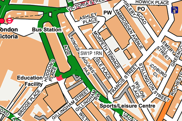
SW1P 1RN is located in the Vincent Square electoral ward, within the London borough of Westminster and the English Parliamentary constituency of Cities of London and Westminster. The Sub Integrated Care Board (ICB) Location is NHS North West London ICB - W2U3Z and the police force is Metropolitan Police. This postcode has been in use since January 2016.


GetTheData
Source: OS OpenMap – Local (Ordnance Survey)
Source: OS VectorMap District (Ordnance Survey)
Licence: Open Government Licence (requires attribution)
| Easting | 529158 |
| Northing | 178979 |
| Latitude | 51.495008 |
| Longitude | -0.140852 |
GetTheData
Source: Open Postcode Geo
Licence: Open Government Licence
| Country | England |
| Postcode District | SW1P |
➜ See where SW1P is on a map ➜ Where is City of Westminster? | |
GetTheData
Source: Land Registry Price Paid Data
Licence: Open Government Licence
Elevation or altitude of SW1P 1RN as distance above sea level:
| Metres | Feet | |
|---|---|---|
| Elevation | 10m | 33ft |
Elevation is measured from the approximate centre of the postcode, to the nearest point on an OS contour line from OS Terrain 50, which has contour spacing of ten vertical metres.
➜ How high above sea level am I? Find the elevation of your current position using your device's GPS.
GetTheData
Source: Open Postcode Elevation
Licence: Open Government Licence
| Ward | Vincent Square |
| Constituency | Cities Of London And Westminster |
GetTheData
Source: ONS Postcode Database
Licence: Open Government Licence
| Neathouse Place (Vauxhall Bridge Road) | Victoria | 71m |
| Neathouse Place (Vauxhall Bridge Road) | Victoria | 82m |
| Westminster Cathedralvictoria | Victoria | 116m |
| Victoria (Wilton Road) | Victoria | 119m |
| Victoria | Victoria | 129m |
| Victoria Underground Station | Victoria | 217m |
| St. James's Park Underground Station | St James's Park | 712m |
| Pimlico Underground Station | Pimlico | 822m |
| Sloane Square Underground Station | Sloane Square | 1,120m |
| Hyde Park Corner Underground Station | Hyde Park Corner | 1,202m |
| London Victoria Station | 0.3km |
| Vauxhall Station | 1.6km |
| London Charing Cross Station | 1.8km |
GetTheData
Source: NaPTAN
Licence: Open Government Licence
| Percentage of properties with Next Generation Access | 100.0% |
| Percentage of properties with Superfast Broadband | 100.0% |
| Percentage of properties with Ultrafast Broadband | 0.0% |
| Percentage of properties with Full Fibre Broadband | 0.0% |
Superfast Broadband is between 30Mbps and 300Mbps
Ultrafast Broadband is > 300Mbps
| Percentage of properties unable to receive 2Mbps | 0.0% |
| Percentage of properties unable to receive 5Mbps | 0.0% |
| Percentage of properties unable to receive 10Mbps | 0.0% |
| Percentage of properties unable to receive 30Mbps | 0.0% |
GetTheData
Source: Ofcom
Licence: Ofcom Terms of Use (requires attribution)
GetTheData
Source: ONS Postcode Database
Licence: Open Government Licence


➜ Get more ratings from the Food Standards Agency
GetTheData
Source: Food Standards Agency
Licence: FSA terms & conditions
| Last Collection | |||
|---|---|---|---|
| Location | Mon-Fri | Sat | Distance |
| 1g Carlisle Place | 18:30 | 11:30 | 70m |
| Vauxhall Bridge Road | 18:30 | 11:30 | 101m |
| 330 Vauxhall Bridge Road | 18:30 | 12:30 | 163m |
GetTheData
Source: Dracos
Licence: Creative Commons Attribution-ShareAlike
| Risk of SW1P 1RN flooding from rivers and sea | Very Low |
| ➜ SW1P 1RN flood map | |
GetTheData
Source: Open Flood Risk by Postcode
Licence: Open Government Licence
The below table lists the International Territorial Level (ITL) codes (formerly Nomenclature of Territorial Units for Statistics (NUTS) codes) and Local Administrative Units (LAU) codes for SW1P 1RN:
| ITL 1 Code | Name |
|---|---|
| TLI | London |
| ITL 2 Code | Name |
| TLI3 | Inner London - West |
| ITL 3 Code | Name |
| TLI32 | Westminster |
| LAU 1 Code | Name |
| E09000033 | Westminster |
GetTheData
Source: ONS Postcode Directory
Licence: Open Government Licence
The below table lists the Census Output Area (OA), Lower Layer Super Output Area (LSOA), and Middle Layer Super Output Area (MSOA) for SW1P 1RN:
| Code | Name | |
|---|---|---|
| OA | E00024006 | |
| LSOA | E01004748 | Westminster 020E |
| MSOA | E02000979 | Westminster 020 |
GetTheData
Source: ONS Postcode Directory
Licence: Open Government Licence
| SW1P 1HZ | Carlisle Place | 6m |
| SW1P 1HX | Carlisle Place | 37m |
| SW1V 1BP | Vauxhall Bridge Road | 40m |
| SW1V 1BS | Vauxhall Bridge Road | 54m |
| SW1P 1ER | Morpeth Terrace | 62m |
| SW1P 1NP | Carlisle Place | 63m |
| SW1P 1EW | Morpeth Terrace | 70m |
| SW1P 1HY | Carlisle Place | 72m |
| SW1V 1AA | Vauxhall Bridge Road | 75m |
| SW1P 1EZ | Carlisle Place | 76m |
GetTheData
Source: Open Postcode Geo; Land Registry Price Paid Data
Licence: Open Government Licence