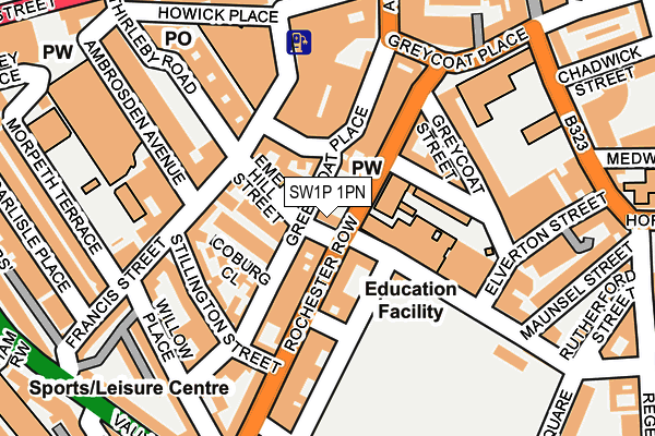
SW1P 1PN lies on Emery Hill Street in London. SW1P 1PN is located in the Vincent Square electoral ward, within the London borough of Westminster and the English Parliamentary constituency of Cities of London and Westminster. The Sub Integrated Care Board (ICB) Location is NHS North West London ICB - W2U3Z and the police force is Metropolitan Police. This postcode has been in use since December 1998.


GetTheData
Source: OS OpenMap – Local (Ordnance Survey)
Source: OS VectorMap District (Ordnance Survey)
Licence: Open Government Licence (requires attribution)
| Easting | 529430 |
| Northing | 179010 |
| Latitude | 51.495226 |
| Longitude | -0.136900 |
GetTheData
Source: Open Postcode Geo
Licence: Open Government Licence
| Street | Emery Hill Street |
| Town/City | London |
| Country | England |
| Postcode District | SW1P |
➜ See where SW1P is on a map ➜ Where is City of Westminster? | |
GetTheData
Source: Land Registry Price Paid Data
Licence: Open Government Licence
Elevation or altitude of SW1P 1PN as distance above sea level:
| Metres | Feet | |
|---|---|---|
| Elevation | 10m | 33ft |
Elevation is measured from the approximate centre of the postcode, to the nearest point on an OS contour line from OS Terrain 50, which has contour spacing of ten vertical metres.
➜ How high above sea level am I? Find the elevation of your current position using your device's GPS.
GetTheData
Source: Open Postcode Elevation
Licence: Open Government Licence
| Ward | Vincent Square |
| Constituency | Cities Of London And Westminster |
GetTheData
Source: ONS Postcode Database
Licence: Open Government Licence
| Rochester Row Vane Street | Pimlico | 120m |
| Westminster City Hall (Victoria Street) | Westminster | 217m |
| Westminster City Hall (Victoria Street) | Westminster | 245m |
| Strutton Ground (Horseferry Road) | Westminster | 253m |
| Rochester Row | Pimlico | 259m |
| Victoria Underground Station | Victoria | 447m |
| St. James's Park Underground Station | St James's Park | 533m |
| Pimlico Underground Station | Pimlico | 716m |
| Westminster Underground Station | Westminster | 1,077m |
| Green Park Underground Station | Green Park | 1,366m |
| London Victoria Station | 0.5km |
| Vauxhall Station | 1.4km |
| London Charing Cross Station | 1.7km |
GetTheData
Source: NaPTAN
Licence: Open Government Licence
| Percentage of properties with Next Generation Access | 0.0% |
| Percentage of properties with Superfast Broadband | 0.0% |
| Percentage of properties with Ultrafast Broadband | 0.0% |
| Percentage of properties with Full Fibre Broadband | 0.0% |
Superfast Broadband is between 30Mbps and 300Mbps
Ultrafast Broadband is > 300Mbps
| Median download speed | 17.1Mbps |
| Average download speed | 16.8Mbps |
| Maximum download speed | 19.55Mbps |
| Median upload speed | 1.1Mbps |
| Average upload speed | 1.1Mbps |
| Maximum upload speed | 1.25Mbps |
| Percentage of properties unable to receive 2Mbps | 0.0% |
| Percentage of properties unable to receive 5Mbps | 0.0% |
| Percentage of properties unable to receive 10Mbps | 0.0% |
| Percentage of properties unable to receive 30Mbps | 100.0% |
GetTheData
Source: Ofcom
Licence: Ofcom Terms of Use (requires attribution)
Estimated total energy consumption in SW1P 1PN by fuel type, 2015.
| Consumption (kWh) | 86,685 |
|---|---|
| Meter count | 31 |
| Mean (kWh/meter) | 2,796 |
| Median (kWh/meter) | 2,503 |
GetTheData
Source: Postcode level gas estimates: 2015 (experimental)
Source: Postcode level electricity estimates: 2015 (experimental)
Licence: Open Government Licence
GetTheData
Source: ONS Postcode Database
Licence: Open Government Licence


➜ Get more ratings from the Food Standards Agency
GetTheData
Source: Food Standards Agency
Licence: FSA terms & conditions
| Last Collection | |||
|---|---|---|---|
| Location | Mon-Fri | Sat | Distance |
| 54 Rochester Row | 18:45 | 11:30 | 78m |
| Post Office | 18:30 | 11:30 | 170m |
| Greycoat Place | 18:30 | 11:30 | 185m |
GetTheData
Source: Dracos
Licence: Creative Commons Attribution-ShareAlike
| Risk of SW1P 1PN flooding from rivers and sea | Very Low |
| ➜ SW1P 1PN flood map | |
GetTheData
Source: Open Flood Risk by Postcode
Licence: Open Government Licence
The below table lists the International Territorial Level (ITL) codes (formerly Nomenclature of Territorial Units for Statistics (NUTS) codes) and Local Administrative Units (LAU) codes for SW1P 1PN:
| ITL 1 Code | Name |
|---|---|
| TLI | London |
| ITL 2 Code | Name |
| TLI3 | Inner London - West |
| ITL 3 Code | Name |
| TLI32 | Westminster |
| LAU 1 Code | Name |
| E09000033 | Westminster |
GetTheData
Source: ONS Postcode Directory
Licence: Open Government Licence
The below table lists the Census Output Area (OA), Lower Layer Super Output Area (LSOA), and Middle Layer Super Output Area (MSOA) for SW1P 1PN:
| Code | Name | |
|---|---|---|
| OA | E00024034 | |
| LSOA | E01004744 | Westminster 020D |
| MSOA | E02000979 | Westminster 020 |
GetTheData
Source: ONS Postcode Directory
Licence: Open Government Licence
| SW1P 1PD | Emery Hill Street | 26m |
| SW1P 1PG | Greencoat Row | 35m |
| SW1P 1PA | Ashley Gardens | 45m |
| SW1P 1DS | Greencoat Place | 68m |
| SW1P 1HN | Thirleby Road | 84m |
| SW1P 1BS | Rochester Row | 84m |
| SW1P 1NS | Rochester Row | 84m |
| SW1P 1HW | Thirleby Road | 84m |
| SW1P 1JU | Rochester Row | 88m |
| SW1P 1QQ | Ambrosden Avenue | 91m |
GetTheData
Source: Open Postcode Geo; Land Registry Price Paid Data
Licence: Open Government Licence