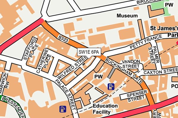
SW1E 6PA lies on Buckingham Gate in London. SW1E 6PA is located in the St James's electoral ward, within the London borough of Westminster and the English Parliamentary constituency of Cities of London and Westminster. The Sub Integrated Care Board (ICB) Location is NHS North West London ICB - W2U3Z and the police force is Metropolitan Police. This postcode has been in use since January 1980.


GetTheData
Source: OS OpenMap – Local (Ordnance Survey)
Source: OS VectorMap District (Ordnance Survey)
Licence: Open Government Licence (requires attribution)
| Easting | 529296 |
| Northing | 179427 |
| Latitude | 51.499003 |
| Longitude | -0.138701 |
GetTheData
Source: Open Postcode Geo
Licence: Open Government Licence
| Street | Buckingham Gate |
| Town/City | London |
| Country | England |
| Postcode District | SW1E |
➜ See where SW1E is on a map ➜ Where is City of Westminster? | |
GetTheData
Source: Land Registry Price Paid Data
Licence: Open Government Licence
Elevation or altitude of SW1E 6PA as distance above sea level:
| Metres | Feet | |
|---|---|---|
| Elevation | 10m | 33ft |
Elevation is measured from the approximate centre of the postcode, to the nearest point on an OS contour line from OS Terrain 50, which has contour spacing of ten vertical metres.
➜ How high above sea level am I? Find the elevation of your current position using your device's GPS.
GetTheData
Source: Open Postcode Elevation
Licence: Open Government Licence
| Ward | St James's |
| Constituency | Cities Of London And Westminster |
GetTheData
Source: ONS Postcode Database
Licence: Open Government Licence
| Westminster City Hall (Victoria Street) | Westminster | 224m |
| Westminster City Hall (Victoria Street) | Westminster | 227m |
| Westminster Cathedral | Westminster | 265m |
| Buckingham Palace | Victoria | 266m |
| Buckingham Palace | Victoria | 278m |
| St. James's Park Underground Station | St James's Park | 359m |
| Victoria Underground Station | Victoria | 424m |
| Green Park Underground Station | Green Park | 928m |
| Westminster Underground Station | Westminster | 995m |
| Hyde Park Corner Underground Station | Hyde Park Corner | 1,054m |
| London Victoria Station | 0.6km |
| London Charing Cross Station | 1.4km |
| Vauxhall Station | 1.8km |
GetTheData
Source: NaPTAN
Licence: Open Government Licence
| Percentage of properties with Next Generation Access | 100.0% |
| Percentage of properties with Superfast Broadband | 100.0% |
| Percentage of properties with Ultrafast Broadband | 100.0% |
| Percentage of properties with Full Fibre Broadband | 100.0% |
Superfast Broadband is between 30Mbps and 300Mbps
Ultrafast Broadband is > 300Mbps
| Median download speed | 20.5Mbps |
| Average download speed | 40.9Mbps |
| Maximum download speed | 80.00Mbps |
| Median upload speed | 1.3Mbps |
| Average upload speed | 7.9Mbps |
| Maximum upload speed | 20.00Mbps |
| Percentage of properties unable to receive 2Mbps | 0.0% |
| Percentage of properties unable to receive 5Mbps | 0.0% |
| Percentage of properties unable to receive 10Mbps | 0.0% |
| Percentage of properties unable to receive 30Mbps | 0.0% |
GetTheData
Source: Ofcom
Licence: Ofcom Terms of Use (requires attribution)
Estimated total energy consumption in SW1E 6PA by fuel type, 2015.
| Consumption (kWh) | 57,887 |
|---|---|
| Meter count | 6 |
| Mean (kWh/meter) | 9,648 |
| Median (kWh/meter) | 362 |
| Consumption (kWh) | 150,198 |
|---|---|
| Meter count | 48 |
| Mean (kWh/meter) | 3,129 |
| Median (kWh/meter) | 2,968 |
GetTheData
Source: Postcode level gas estimates: 2015 (experimental)
Source: Postcode level electricity estimates: 2015 (experimental)
Licence: Open Government Licence
GetTheData
Source: ONS Postcode Database
Licence: Open Government Licence


➜ Get more ratings from the Food Standards Agency
GetTheData
Source: Food Standards Agency
Licence: FSA terms & conditions
| Last Collection | |||
|---|---|---|---|
| Location | Mon-Fri | Sat | Distance |
| Buckingham Gate | 18:30 | 11:30 | 50m |
| Palace Street | 18:30 | 11:30 | 133m |
| Palace Street | 18:30 | 11:30 | 235m |
GetTheData
Source: Dracos
Licence: Creative Commons Attribution-ShareAlike
| Risk of SW1E 6PA flooding from rivers and sea | Very Low |
| ➜ SW1E 6PA flood map | |
GetTheData
Source: Open Flood Risk by Postcode
Licence: Open Government Licence
The below table lists the International Territorial Level (ITL) codes (formerly Nomenclature of Territorial Units for Statistics (NUTS) codes) and Local Administrative Units (LAU) codes for SW1E 6PA:
| ITL 1 Code | Name |
|---|---|
| TLI | London |
| ITL 2 Code | Name |
| TLI3 | Inner London - West |
| ITL 3 Code | Name |
| TLI32 | Westminster |
| LAU 1 Code | Name |
| E09000033 | Westminster |
GetTheData
Source: ONS Postcode Directory
Licence: Open Government Licence
The below table lists the Census Output Area (OA), Lower Layer Super Output Area (LSOA), and Middle Layer Super Output Area (MSOA) for SW1E 6PA:
| Code | Name | |
|---|---|---|
| OA | E00023943 | |
| LSOA | E01004731 | Westminster 020A |
| MSOA | E02000979 | Westminster 020 |
GetTheData
Source: ONS Postcode Directory
Licence: Open Government Licence
| SW1E 6PB | Buckingham Gate | 16m |
| SW1E 6PH | Wilfred Street | 35m |
| SW1E 6NF | Buckingham Gate | 46m |
| SW1E 6PR | Wilfred Street | 54m |
| SW1E 6PE | Buckingham Gate | 58m |
| SW1E 6DR | Castle Lane | 70m |
| SW1H 9ET | Petty France | 75m |
| SW1E 6BS | Buckingham Gate | 81m |
| SW1E 6HL | Catherine Place | 83m |
| SW1E 6AL | Buckingham Gate | 84m |
GetTheData
Source: Open Postcode Geo; Land Registry Price Paid Data
Licence: Open Government Licence