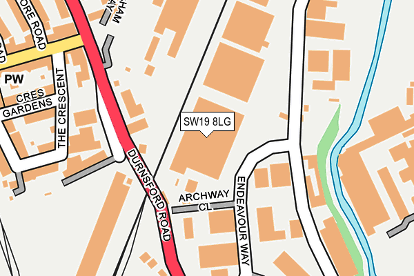
SW19 8LG is located in the Wimbledon Park electoral ward, within the London borough of Merton and the English Parliamentary constituency of Wimbledon. The Sub Integrated Care Board (ICB) Location is NHS South West London ICB - 36L and the police force is Metropolitan Police. This postcode has been in use since April 1986.


GetTheData
Source: OS OpenMap – Local (Ordnance Survey)
Source: OS VectorMap District (Ordnance Survey)
Licence: Open Government Licence (requires attribution)
| Easting | 525650 |
| Northing | 172086 |
| Latitude | 51.433850 |
| Longitude | -0.193805 |
GetTheData
Source: Open Postcode Geo
Licence: Open Government Licence
| Country | England |
| Postcode District | SW19 |
| ➜ SW19 open data dashboard ➜ See where SW19 is on a map ➜ Where is Wimbledon? | |
GetTheData
Source: Land Registry Price Paid Data
Licence: Open Government Licence
Elevation or altitude of SW19 8LG as distance above sea level:
| Metres | Feet | |
|---|---|---|
| Elevation | 20m | 66ft |
Elevation is measured from the approximate centre of the postcode, to the nearest point on an OS contour line from OS Terrain 50, which has contour spacing of ten vertical metres.
➜ How high above sea level am I? Find the elevation of your current position using your device's GPS.
GetTheData
Source: Open Postcode Elevation
Licence: Open Government Licence
| Ward | Wimbledon Park |
| Constituency | Wimbledon |
GetTheData
Source: ONS Postcode Database
Licence: Open Government Licence
| June 2022 | Violence and sexual offences | On or near Pedestrian Subway | 155m |
| June 2022 | Theft from the person | On or near Crescent Gardens | 264m |
| June 2022 | Burglary | On or near Bentley Close | 280m |
| ➜ Get more crime data in our Crime section | |||
GetTheData
Source: data.police.uk
Licence: Open Government Licence
| Wimbledon Park Arthur Road (Durnsford Road) | Wimbledon Park | 191m |
| Pitt Crescent (Durnsford Road) | Wimbledon Park | 318m |
| Wimbledon Park Arthur Road (Durnsford Road) | Wimbledon Park | 323m |
| Pitt Crescent (Durnsford Road) | Wimbledon Park | 369m |
| Stroud Road (Durnsford Road) | Wimbledon Park | 463m |
| Wimbledon Park Underground Station | Wimbledon Park | 419m |
| Southfields Underground Station | Southfields | 1,533m |
| Wimbledon Tram Stop (The Broadway) | Wimbledon | 1,651m |
| Wimbledon Underground Station | Wimbledon | 1,663m |
| Haydons Road Station | 1km |
| Earlsfield Station | 1km |
| Wimbledon Station | 1.6km |
GetTheData
Source: NaPTAN
Licence: Open Government Licence
GetTheData
Source: ONS Postcode Database
Licence: Open Government Licence


➜ Get more ratings from the Food Standards Agency
GetTheData
Source: Food Standards Agency
Licence: FSA terms & conditions
| Last Collection | |||
|---|---|---|---|
| Location | Mon-Fri | Sat | Distance |
| Endeavour Way | 17:30 | 12:00 | 134m |
| 120 Durnsford Road | 17:30 | 12:00 | 335m |
| Post Office | 17:30 | 12:00 | 345m |
GetTheData
Source: Dracos
Licence: Creative Commons Attribution-ShareAlike
| Facility | Distance |
|---|---|
| Bounce Gym Durnsford Road, London Health and Fitness Gym | 186m |
| Garratt Park Maskell Road, London Grass Pitches | 412m |
| Afc Wimbledon (Plough Lane) Plough Lane, London Grass Pitches | 535m |
GetTheData
Source: Active Places
Licence: Open Government Licence
| School | Phase of Education | Distance |
|---|---|---|
| Wimbledon Park Primary School Havana Road, London, SW19 8EJ | Primary | 490m |
| Tram House School Tram House School 520 Garratt Lane, London, SW17 0NY | Not applicable | 624m |
| Garratt Park School Waldron Road, Earlsfield, Wandsworth, London, SW18 3TB | Not applicable | 640m |
GetTheData
Source: Edubase
Licence: Open Government Licence
The below table lists the International Territorial Level (ITL) codes (formerly Nomenclature of Territorial Units for Statistics (NUTS) codes) and Local Administrative Units (LAU) codes for SW19 8LG:
| ITL 1 Code | Name |
|---|---|
| TLI | London |
| ITL 2 Code | Name |
| TLI6 | Outer London - South |
| ITL 3 Code | Name |
| TLI63 | Merton, Kingston upon Thames and Sutton |
| LAU 1 Code | Name |
| E09000024 | Merton |
GetTheData
Source: ONS Postcode Directory
Licence: Open Government Licence
The below table lists the Census Output Area (OA), Lower Layer Super Output Area (LSOA), and Middle Layer Super Output Area (MSOA) for SW19 8LG:
| Code | Name | |
|---|---|---|
| OA | E00017583 | |
| LSOA | E01003475 | Merton 001D |
| MSOA | E02000689 | Merton 001 |
GetTheData
Source: ONS Postcode Directory
Licence: Open Government Licence
| SW19 8HW | Railway Cottages | 195m |
| SW19 8LW | The Crescent | 217m |
| SW19 8UG | Weir Road | 224m |
| SW19 8AG | Arthur Road | 257m |
| SW19 8AJ | Crescent Gardens | 262m |
| SW19 8AQ | Arthur Road | 269m |
| SW19 8ED | Gresham Way | 272m |
| SW19 8DD | Arthur Road | 273m |
| SW19 8AW | The Crescent | 274m |
| SW19 8HJ | Durnsford Road | 279m |
GetTheData
Source: Open Postcode Geo; Land Registry Price Paid Data
Licence: Open Government Licence