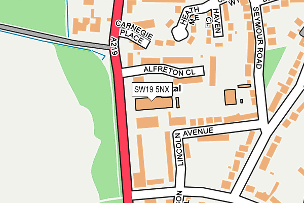
SW19 5NX is located in the Village electoral ward, within the London borough of Merton and the English Parliamentary constituency of Wimbledon. The Sub Integrated Care Board (ICB) Location is NHS South West London ICB - 36L and the police force is Metropolitan Police. This postcode has been in use since April 1986.


GetTheData
Source: OS OpenMap – Local (Ordnance Survey)
Source: OS VectorMap District (Ordnance Survey)
Licence: Open Government Licence (requires attribution)
| Easting | 523598 |
| Northing | 172245 |
| Latitude | 51.435730 |
| Longitude | -0.223230 |
GetTheData
Source: Open Postcode Geo
Licence: Open Government Licence
| Country | England |
| Postcode District | SW19 |
| ➜ SW19 open data dashboard ➜ See where SW19 is on a map ➜ Where is Wimbledon? | |
GetTheData
Source: Land Registry Price Paid Data
Licence: Open Government Licence
Elevation or altitude of SW19 5NX as distance above sea level:
| Metres | Feet | |
|---|---|---|
| Elevation | 50m | 164ft |
Elevation is measured from the approximate centre of the postcode, to the nearest point on an OS contour line from OS Terrain 50, which has contour spacing of ten vertical metres.
➜ How high above sea level am I? Find the elevation of your current position using your device's GPS.
GetTheData
Source: Open Postcode Elevation
Licence: Open Government Licence
| Ward | Village |
| Constituency | Wimbledon |
GetTheData
Source: ONS Postcode Database
Licence: Open Government Licence
| December 2023 | Burglary | On or near Greenoak Way | 290m |
| January 2023 | Violence and sexual offences | On or near Somerset Road | 394m |
| June 2022 | Theft from the person | On or near Hospital | 24m |
| ➜ Get more crime data in our Crime section | |||
GetTheData
Source: data.police.uk
Licence: Open Government Licence
| Parkside Hospital | Wimbledon Park | 90m |
| Parkside Hospital | Wimbledon Park | 110m |
| Calonne Road | Wimbledon | 259m |
| Calonne Road | Wimbledon | 368m |
| Queensmere Road | Putney Vale | 392m |
| Southfields Underground Station | Southfields | 1,556m |
| Wimbledon Station | 2km |
| Earlsfield Station | 2.6km |
| Haydons Road Station | 2.7km |
GetTheData
Source: NaPTAN
Licence: Open Government Licence
GetTheData
Source: ONS Postcode Database
Licence: Open Government Licence


➜ Get more ratings from the Food Standards Agency
GetTheData
Source: Food Standards Agency
Licence: FSA terms & conditions
| Last Collection | |||
|---|---|---|---|
| Location | Mon-Fri | Sat | Distance |
| Calonne Road | 17:30 | 12:00 | 320m |
| Seymour Road | 17:30 | 12:00 | 322m |
| Atherton Drive | 17:30 | 12:00 | 430m |
GetTheData
Source: Dracos
Licence: Creative Commons Attribution-ShareAlike
| Facility | Distance |
|---|---|
| London Scottish Golf Club Windmill Road, London Golf | 659m |
| All England Lawn Tennis And Croquet Club Church Road, London Indoor Tennis Centre, Health and Fitness Gym, Outdoor Tennis Courts | 688m |
| St Pauls Community Centre Inner Park Road, London Sports Hall | 863m |
GetTheData
Source: Active Places
Licence: Open Government Licence
| School | Phase of Education | Distance |
|---|---|---|
| Victoria Drive Primary Pupil Referral Unit 78 Victoria Drive, Southfields, London, SW19 6HR | Not applicable | 849m |
| Albemarle Primary School Princes Way, London, SW19 6JP | Primary | 953m |
| Linden Lodge School 61 Princes Way, Wimbledon Park, London, SW19 6JB | Not applicable | 1.1km |
GetTheData
Source: Edubase
Licence: Open Government Licence
The below table lists the International Territorial Level (ITL) codes (formerly Nomenclature of Territorial Units for Statistics (NUTS) codes) and Local Administrative Units (LAU) codes for SW19 5NX:
| ITL 1 Code | Name |
|---|---|
| TLI | London |
| ITL 2 Code | Name |
| TLI6 | Outer London - South |
| ITL 3 Code | Name |
| TLI63 | Merton, Kingston upon Thames and Sutton |
| LAU 1 Code | Name |
| E09000024 | Merton |
GetTheData
Source: ONS Postcode Directory
Licence: Open Government Licence
The below table lists the Census Output Area (OA), Lower Layer Super Output Area (LSOA), and Middle Layer Super Output Area (MSOA) for SW19 5NX:
| Code | Name | |
|---|---|---|
| OA | E00017527 | |
| LSOA | E01003464 | Merton 002C |
| MSOA | E02000690 | Merton 002 |
GetTheData
Source: ONS Postcode Directory
Licence: Open Government Licence
| SW19 5NE | Parkside | 52m |
| SW19 5NS | Alfreton Close | 89m |
| SW19 5JT | Lincoln Avenue | 103m |
| SW19 5JP | Heath Mead | 119m |
| SW19 5NG | Carnegie Place | 131m |
| SW19 5JU | Somerset Road | 160m |
| SW19 5JW | Haven Close | 163m |
| SW19 5EL | Lawson Close | 194m |
| SW19 5NH | Castle Close | 204m |
| SW19 5JL | Seymour Road | 216m |
GetTheData
Source: Open Postcode Geo; Land Registry Price Paid Data
Licence: Open Government Licence