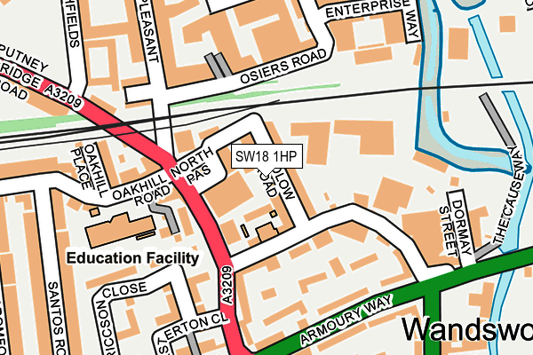
SW18 1HP lies on Sudlow Road in London. SW18 1HP is located in the Wandsworth Town electoral ward, within the London borough of Wandsworth and the English Parliamentary constituency of Battersea. The Sub Integrated Care Board (ICB) Location is NHS South West London ICB - 36L and the police force is Metropolitan Police. This postcode has been in use since January 1980.


GetTheData
Source: OS OpenMap – Local (Ordnance Survey)
Source: OS VectorMap District (Ordnance Survey)
Licence: Open Government Licence (requires attribution)
| Easting | 525316 |
| Northing | 174960 |
| Latitude | 51.459753 |
| Longitude | -0.197591 |
GetTheData
Source: Open Postcode Geo
Licence: Open Government Licence
| Street | Sudlow Road |
| Town/City | London |
| Country | England |
| Postcode District | SW18 |
➜ See where SW18 is on a map ➜ Where is London? | |
GetTheData
Source: Land Registry Price Paid Data
Licence: Open Government Licence
Elevation or altitude of SW18 1HP as distance above sea level:
| Metres | Feet | |
|---|---|---|
| Elevation | 10m | 33ft |
Elevation is measured from the approximate centre of the postcode, to the nearest point on an OS contour line from OS Terrain 50, which has contour spacing of ten vertical metres.
➜ How high above sea level am I? Find the elevation of your current position using your device's GPS.
GetTheData
Source: Open Postcode Elevation
Licence: Open Government Licence
| Ward | Wandsworth Town |
| Constituency | Battersea |
GetTheData
Source: ONS Postcode Database
Licence: Open Government Licence
| Frogmore (Putney Bridge Road) | Wandsworth | 121m |
| Frogmore (Putney Bridge Road) | Wandsworth | 147m |
| Armoury Way | Wandsworth | 173m |
| Armoury Way | Wandsworth | 175m |
| Wandsworth Plain | Wandsworth | 241m |
| East Putney Underground Station | East Putney | 934m |
| Putney Bridge Underground Station | Putney Bridge | 1,223m |
| Wandsworth Town Station | 0.7km |
| Putney Station | 1.3km |
| Clapham Junction Station | 2km |
GetTheData
Source: NaPTAN
Licence: Open Government Licence
| Percentage of properties with Next Generation Access | 100.0% |
| Percentage of properties with Superfast Broadband | 100.0% |
| Percentage of properties with Ultrafast Broadband | 100.0% |
| Percentage of properties with Full Fibre Broadband | 0.0% |
Superfast Broadband is between 30Mbps and 300Mbps
Ultrafast Broadband is > 300Mbps
| Median download speed | 73.3Mbps |
| Average download speed | 82.3Mbps |
| Maximum download speed | 350.00Mbps |
| Median upload speed | 10.0Mbps |
| Average upload speed | 10.5Mbps |
| Maximum upload speed | 20.00Mbps |
| Percentage of properties unable to receive 2Mbps | 0.0% |
| Percentage of properties unable to receive 5Mbps | 0.0% |
| Percentage of properties unable to receive 10Mbps | 0.0% |
| Percentage of properties unable to receive 30Mbps | 0.0% |
GetTheData
Source: Ofcom
Licence: Ofcom Terms of Use (requires attribution)
Estimated total energy consumption in SW18 1HP by fuel type, 2015.
| Consumption (kWh) | 849,659 |
|---|---|
| Meter count | 56 |
| Mean (kWh/meter) | 15,172 |
| Median (kWh/meter) | 15,163 |
| Consumption (kWh) | 181,358 |
|---|---|
| Meter count | 55 |
| Mean (kWh/meter) | 3,297 |
| Median (kWh/meter) | 2,735 |
GetTheData
Source: Postcode level gas estimates: 2015 (experimental)
Source: Postcode level electricity estimates: 2015 (experimental)
Licence: Open Government Licence
GetTheData
Source: ONS Postcode Database
Licence: Open Government Licence


➜ Get more ratings from the Food Standards Agency
GetTheData
Source: Food Standards Agency
Licence: FSA terms & conditions
| Last Collection | |||
|---|---|---|---|
| Location | Mon-Fri | Sat | Distance |
| Putney Bridge Road | 17:30 | 12:00 | 114m |
| Armoury Way | 17:30 | 12:00 | 206m |
| Eastfields Avenue | 17:30 | 12:00 | 279m |
GetTheData
Source: Dracos
Licence: Creative Commons Attribution-ShareAlike
| Risk of SW18 1HP flooding from rivers and sea | Very Low |
| ➜ SW18 1HP flood map | |
GetTheData
Source: Open Flood Risk by Postcode
Licence: Open Government Licence
The below table lists the International Territorial Level (ITL) codes (formerly Nomenclature of Territorial Units for Statistics (NUTS) codes) and Local Administrative Units (LAU) codes for SW18 1HP:
| ITL 1 Code | Name |
|---|---|
| TLI | London |
| ITL 2 Code | Name |
| TLI3 | Inner London - West |
| ITL 3 Code | Name |
| TLI34 | Wandsworth |
| LAU 1 Code | Name |
| E09000032 | Wandsworth |
GetTheData
Source: ONS Postcode Directory
Licence: Open Government Licence
The below table lists the Census Output Area (OA), Lower Layer Super Output Area (LSOA), and Middle Layer Super Output Area (MSOA) for SW18 1HP:
| Code | Name | |
|---|---|---|
| OA | E00022688 | |
| LSOA | E01004511 | Wandsworth 010B |
| MSOA | E02000932 | Wandsworth 010 |
GetTheData
Source: ONS Postcode Directory
Licence: Open Government Licence
| SW18 1HR | Putney Bridge Road | 48m |
| SW18 1HW | Frogmore | 74m |
| SW15 2QE | Pembridge Place | 103m |
| SW18 1HH | Frogmore | 119m |
| SW18 1HJ | Frogmore | 126m |
| SW18 1HE | Osiers Road | 128m |
| SW18 1NL | Osiers Road | 134m |
| SW18 1HN | Frogmore | 141m |
| SW18 1GZ | Knightley Walk | 142m |
| SW18 1SG | Ericcson Close | 152m |
GetTheData
Source: Open Postcode Geo; Land Registry Price Paid Data
Licence: Open Government Licence