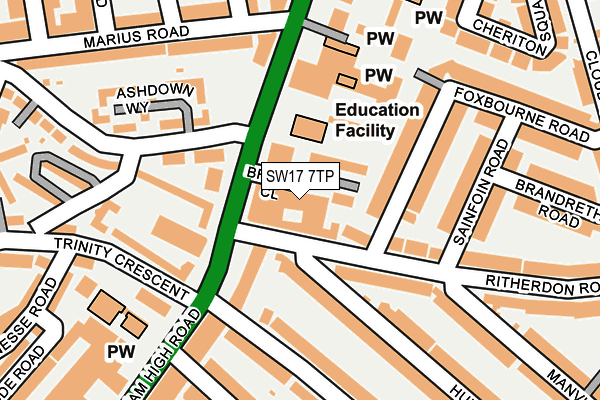
SW17 7TP is located in the South Balham electoral ward, within the London borough of Wandsworth and the English Parliamentary constituency of Tooting. The Sub Integrated Care Board (ICB) Location is NHS South West London ICB - 36L and the police force is Metropolitan Police. This postcode has been in use since August 2013.


GetTheData
Source: OS OpenMap – Local (Ordnance Survey)
Source: OS VectorMap District (Ordnance Survey)
Licence: Open Government Licence (requires attribution)
| Easting | 528255 |
| Northing | 172659 |
| Latitude | 51.438417 |
| Longitude | -0.156118 |
GetTheData
Source: Open Postcode Geo
Licence: Open Government Licence
| Country | England |
| Postcode District | SW17 |
| ➜ SW17 open data dashboard ➜ See where SW17 is on a map ➜ Where is London? | |
GetTheData
Source: Land Registry Price Paid Data
Licence: Open Government Licence
Elevation or altitude of SW17 7TP as distance above sea level:
| Metres | Feet | |
|---|---|---|
| Elevation | 30m | 98ft |
Elevation is measured from the approximate centre of the postcode, to the nearest point on an OS contour line from OS Terrain 50, which has contour spacing of ten vertical metres.
➜ How high above sea level am I? Find the elevation of your current position using your device's GPS.
GetTheData
Source: Open Postcode Elevation
Licence: Open Government Licence
| Ward | South Balham |
| Constituency | Tooting |
GetTheData
Source: ONS Postcode Database
Licence: Open Government Licence
| January 2024 | Anti-social behaviour | On or near Foxbourne Road | 272m |
| January 2024 | Anti-social behaviour | On or near Foxbourne Road | 272m |
| January 2024 | Public order | On or near Petrol Station | 389m |
| ➜ Get more crime data in our Crime section | |||
GetTheData
Source: data.police.uk
Licence: Open Government Licence
| Upper Tooting Park Balham High (Balham High Road) | Tooting Bec | 39m |
| Upper Tooting Park Balham High (Balham High Road) | Tooting Bec | 77m |
| Tooting Bec Station | Tooting Bec | 337m |
| Du Cane Court (Balham High Road) | Balham | 352m |
| St Anselm's Church | Tooting Bec | 369m |
| Tooting Bec Underground Station | Tooting Bec | 394m |
| Balham Underground Station | Balham | 584m |
| Tooting Broadway Underground Station | Tooting Broadway | 1,471m |
| Balham Station | 0.6km |
| Wandsworth Common Station | 1km |
| Streatham Hill Station | 2km |
GetTheData
Source: NaPTAN
Licence: Open Government Licence
GetTheData
Source: ONS Postcode Database
Licence: Open Government Licence


➜ Get more ratings from the Food Standards Agency
GetTheData
Source: Food Standards Agency
Licence: FSA terms & conditions
| Last Collection | |||
|---|---|---|---|
| Location | Mon-Fri | Sat | Distance |
| 32 Ritherdon Road | 17:30 | 12:00 | 128m |
| Post Office | 17:30 | 12:00 | 191m |
| Marius Road | 17:30 | 12:00 | 280m |
GetTheData
Source: Dracos
Licence: Creative Commons Attribution-ShareAlike
| Facility | Distance |
|---|---|
| Rutherford House School Balham High Road, London Artificial Grass Pitch | 90m |
| Fitness First (Balham) Balham High Road, London Health and Fitness Gym, Studio | 281m |
| Ravenstone Primary School Ravenstone Street, London Artificial Grass Pitch | 380m |
GetTheData
Source: Active Places
Licence: Open Government Licence
| School | Phase of Education | Distance |
|---|---|---|
| Rutherford House School 217 Balham High Road, Balham, Wandsworth, London, SW17 7BS | Primary | 93m |
| Eveline Day School Swan House, 207 Balham High Road, Balham, London, SW17 7BQ | Not applicable | 232m |
| St Anselm's Catholic Primary School Louisville Road, London, SW17 8RW | Primary | 319m |
GetTheData
Source: Edubase
Licence: Open Government Licence
The below table lists the International Territorial Level (ITL) codes (formerly Nomenclature of Territorial Units for Statistics (NUTS) codes) and Local Administrative Units (LAU) codes for SW17 7TP:
| ITL 1 Code | Name |
|---|---|
| TLI | London |
| ITL 2 Code | Name |
| TLI3 | Inner London - West |
| ITL 3 Code | Name |
| TLI34 | Wandsworth |
| LAU 1 Code | Name |
| E09000032 | Wandsworth |
GetTheData
Source: ONS Postcode Directory
Licence: Open Government Licence
The below table lists the Census Output Area (OA), Lower Layer Super Output Area (LSOA), and Middle Layer Super Output Area (MSOA) for SW17 7TP:
| Code | Name | |
|---|---|---|
| OA | E00022541 | |
| LSOA | E01004485 | Wandsworth 030B |
| MSOA | E02000952 | Wandsworth 030 |
GetTheData
Source: ONS Postcode Directory
Licence: Open Government Licence
| SW17 8QD | Ritherdon Road | 51m |
| SW17 7AJ | Balham High Road | 52m |
| SW17 7SY | Upper Tooting Park | 67m |
| SW17 7BG | Balham High Road | 67m |
| SW17 7AT | Balham High Road | 77m |
| SW17 7SA | Upper Tooting Park | 99m |
| SW17 7AH | Balham High Road | 117m |
| SW17 7BE | Balham High Road | 148m |
| SW17 7TH | Ashdown Way | 153m |
| SW17 7AN | Balham High Road | 158m |
GetTheData
Source: Open Postcode Geo; Land Registry Price Paid Data
Licence: Open Government Licence