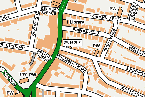
SW16 2UE is located in the Streatham Wells electoral ward, within the London borough of Lambeth and the English Parliamentary constituency of Streatham. The Sub Integrated Care Board (ICB) Location is NHS South East London ICB - 72Q and the police force is Metropolitan Police. This postcode has been in use since January 1980.


GetTheData
Source: OS OpenMap – Local (Ordnance Survey)
Source: OS VectorMap District (Ordnance Survey)
Licence: Open Government Licence (requires attribution)
| Easting | 530188 |
| Northing | 171846 |
| Latitude | 51.430670 |
| Longitude | -0.128647 |
GetTheData
Source: Open Postcode Geo
Licence: Open Government Licence
| Country | England |
| Postcode District | SW16 |
| ➜ SW16 open data dashboard ➜ See where SW16 is on a map ➜ Where is Streatham? | |
GetTheData
Source: Land Registry Price Paid Data
Licence: Open Government Licence
Elevation or altitude of SW16 2UE as distance above sea level:
| Metres | Feet | |
|---|---|---|
| Elevation | 50m | 164ft |
Elevation is measured from the approximate centre of the postcode, to the nearest point on an OS contour line from OS Terrain 50, which has contour spacing of ten vertical metres.
➜ How high above sea level am I? Find the elevation of your current position using your device's GPS.
GetTheData
Source: Open Postcode Elevation
Licence: Open Government Licence
| Ward | Streatham Wells |
| Constituency | Streatham |
GetTheData
Source: ONS Postcode Database
Licence: Open Government Licence
| January 2024 | Burglary | On or near Ockley Road | 213m |
| January 2024 | Other crime | On or near Ockley Road | 213m |
| January 2024 | Other theft | On or near Ockley Road | 213m |
| ➜ Get more crime data in our Crime section | |||
GetTheData
Source: data.police.uk
Licence: Open Government Licence
| Streatham High Rdgleneldon Rd | Streatham | 182m |
| Becmead Avenue (Streatham High Road) | Streatham | 187m |
| Becmead Avenue (Streatham High Road) | Streatham | 216m |
| Becmead Avenue (Streatham High Road) | Streatham | 221m |
| Becmead Avenue (Streatham High Road) | Streatham | 242m |
| Streatham Station | 0.6km |
| Streatham Hill Station | 0.8km |
| Streatham Common Station | 1.4km |
GetTheData
Source: NaPTAN
Licence: Open Government Licence
GetTheData
Source: ONS Postcode Database
Licence: Open Government Licence


➜ Get more ratings from the Food Standards Agency
GetTheData
Source: Food Standards Agency
Licence: FSA terms & conditions
| Last Collection | |||
|---|---|---|---|
| Location | Mon-Fri | Sat | Distance |
| 10 Prentis Road | 17:30 | 12:00 | 143m |
| Pendennis Road | 17:30 | 12:00 | 152m |
| Farm Avenue | 17:30 | 12:00 | 159m |
GetTheData
Source: Dracos
Licence: Creative Commons Attribution-ShareAlike
| Facility | Distance |
|---|---|
| Regen London Streatham High Road, Streatham High Road, London Health and Fitness Gym | 154m |
| Virgin Active (Streatham) Ockley Road, London Swimming Pool, Health and Fitness Gym, Studio | 260m |
| Wigmore Lawn Tennis Club Becmead Avenue, London Outdoor Tennis Courts | 376m |
GetTheData
Source: Active Places
Licence: Open Government Licence
| School | Phase of Education | Distance |
|---|---|---|
| Sunnyhill Primary School Sunnyhill Road, Streatham, London, SW16 2UW | Primary | 619m |
| St Leonard's Church of England Primary School 42 Mitcham Lane, Streatham, London, SW16 6NP | Primary | 628m |
| Dunraven School 94-98 Leigham Court Road, LONDON, SW16 2QB | All-through | 684m |
GetTheData
Source: Edubase
Licence: Open Government Licence
The below table lists the International Territorial Level (ITL) codes (formerly Nomenclature of Territorial Units for Statistics (NUTS) codes) and Local Administrative Units (LAU) codes for SW16 2UE:
| ITL 1 Code | Name |
|---|---|
| TLI | London |
| ITL 2 Code | Name |
| TLI4 | Inner London - East |
| ITL 3 Code | Name |
| TLI45 | Lambeth |
| LAU 1 Code | Name |
| E09000022 | Lambeth |
GetTheData
Source: ONS Postcode Directory
Licence: Open Government Licence
The below table lists the Census Output Area (OA), Lower Layer Super Output Area (LSOA), and Middle Layer Super Output Area (MSOA) for SW16 2UE:
| Code | Name | |
|---|---|---|
| OA | E00015931 | |
| LSOA | E01003155 | Lambeth 029E |
| MSOA | E02000646 | Lambeth 029 |
GetTheData
Source: ONS Postcode Directory
Licence: Open Government Licence
| SW16 2UH | Sunnyhill Road | 39m |
| SW16 1PH | Streatham High Road | 57m |
| SW16 2AS | Shrubbery Road | 67m |
| SW16 2SL | Pinfold Road | 74m |
| SW16 2AT | Shrubbery Road | 95m |
| SW16 1BB | Streatham High Road | 96m |
| SW16 1XU | Prentis Road | 106m |
| SW16 2SN | Pinfold Road | 109m |
| SW16 2BW | Nicholls Mews | 110m |
| SW16 2AU | Gleneldon Road | 125m |
GetTheData
Source: Open Postcode Geo; Land Registry Price Paid Data
Licence: Open Government Licence