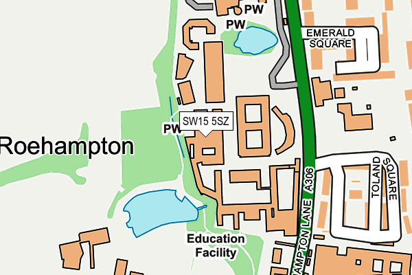
SW15 5SZ is located in the Roehampton electoral ward, within the London borough of Wandsworth and the English Parliamentary constituency of Putney. The Sub Integrated Care Board (ICB) Location is NHS South West London ICB - 36L and the police force is Metropolitan Police. This postcode has been in use since December 1996.


GetTheData
Source: OS OpenMap – Local (Ordnance Survey)
Source: OS VectorMap District (Ordnance Survey)
Licence: Open Government Licence (requires attribution)
| Easting | 522032 |
| Northing | 174614 |
| Latitude | 51.457360 |
| Longitude | -0.244956 |
GetTheData
Source: Open Postcode Geo
Licence: Open Government Licence
| Country | England |
| Postcode District | SW15 |
| ➜ SW15 open data dashboard ➜ See where SW15 is on a map ➜ Where is London? | |
GetTheData
Source: Land Registry Price Paid Data
Licence: Open Government Licence
Elevation or altitude of SW15 5SZ as distance above sea level:
| Metres | Feet | |
|---|---|---|
| Elevation | 30m | 98ft |
Elevation is measured from the approximate centre of the postcode, to the nearest point on an OS contour line from OS Terrain 50, which has contour spacing of ten vertical metres.
➜ How high above sea level am I? Find the elevation of your current position using your device's GPS.
GetTheData
Source: Open Postcode Elevation
Licence: Open Government Licence
| Ward | Roehampton |
| Constituency | Putney |
GetTheData
Source: ONS Postcode Database
Licence: Open Government Licence
| January 2024 | Anti-social behaviour | On or near Aubyn Square | 389m |
| January 2024 | Violence and sexual offences | On or near Aubyn Square | 389m |
| January 2024 | Violence and sexual offences | On or near Aubyn Square | 389m |
| ➜ Get more crime data in our Crime section | |||
GetTheData
Source: data.police.uk
Licence: Open Government Licence
| Roehampton University Main Ent (Roehampton Lane) | Roehampton | 187m |
| Queen Mary's Hospital (Roehampton Lane) | Roehampton | 189m |
| Roehampton University Main Ent | Roehampton | 197m |
| Queen Mary's Hospital (Roehampton Lane) | Roehampton | 220m |
| Fairacres (Roehampton Lane) | Roehampton | 427m |
| Barnes Station | 1.1km |
| Barnes Bridge Station | 1.7km |
| Mortlake Station | 1.9km |
GetTheData
Source: NaPTAN
Licence: Open Government Licence
GetTheData
Source: ONS Postcode Database
Licence: Open Government Licence


➜ Get more ratings from the Food Standards Agency
GetTheData
Source: Food Standards Agency
Licence: FSA terms & conditions
| Last Collection | |||
|---|---|---|---|
| Location | Mon-Fri | Sat | Distance |
| Arton Wilson House | 17:30 | 12:00 | 182m |
| Roehampton Lane | 17:30 | 12:00 | 188m |
| Clarence Lane | 17:30 | 12:00 | 462m |
GetTheData
Source: Dracos
Licence: Creative Commons Attribution-ShareAlike
| Facility | Distance |
|---|---|
| Roehampton University Roehampton Lane, London Sports Hall, Health and Fitness Gym, Studio, Outdoor Tennis Courts | 253m |
| The Bader Gymnasium Roehampton Lane, London Health and Fitness Gym, Sports Hall, Studio | 301m |
| Roehampton Playing Fields Dover House Road, London Grass Pitches, Outdoor Tennis Courts | 601m |
GetTheData
Source: Active Places
Licence: Open Government Licence
| School | Phase of Education | Distance |
|---|---|---|
| Sacred Heart Catholic Primary School, Roehampton Roehampton Lane, Roehampton, London, SW15 5NX | Primary | 227m |
| Roehampton University Roehampton Lane, London, SW15 5PJ | Not applicable | 254m |
| Eastwood Nursery School 168 Roehampton Lane, London, SW15 4EU | Nursery | 601m |
GetTheData
Source: Edubase
Licence: Open Government Licence
The below table lists the International Territorial Level (ITL) codes (formerly Nomenclature of Territorial Units for Statistics (NUTS) codes) and Local Administrative Units (LAU) codes for SW15 5SZ:
| ITL 1 Code | Name |
|---|---|
| TLI | London |
| ITL 2 Code | Name |
| TLI3 | Inner London - West |
| ITL 3 Code | Name |
| TLI34 | Wandsworth |
| LAU 1 Code | Name |
| E09000032 | Wandsworth |
GetTheData
Source: ONS Postcode Directory
Licence: Open Government Licence
The below table lists the Census Output Area (OA), Lower Layer Super Output Area (LSOA), and Middle Layer Super Output Area (MSOA) for SW15 5SZ:
| Code | Name | |
|---|---|---|
| OA | E00170903 | |
| LSOA | E01004568 | Wandsworth 013A |
| MSOA | E02000935 | Wandsworth 013 |
GetTheData
Source: ONS Postcode Directory
Licence: Open Government Licence
| SW15 5PQ | Toland Square | 183m |
| SW15 5PG | Toland Square | 196m |
| SW15 5FN | Roehampton Lane | 216m |
| SW15 5NZ | Toland Square | 221m |
| SW15 5PF | Toland Square | 223m |
| SW15 5FL | Roehampton Lane | 228m |
| SW15 5FJ | Roehampton Lane | 243m |
| SW15 5FP | Emerald Square | 244m |
| SW15 5PE | Toland Square | 261m |
| SW15 5PD | Toland Square | 262m |
GetTheData
Source: Open Postcode Geo; Land Registry Price Paid Data
Licence: Open Government Licence