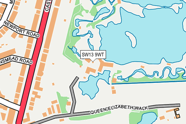
SW13 9WT is located in the Barnes electoral ward, within the London borough of Richmond upon Thames and the English Parliamentary constituency of Richmond Park. The Sub Integrated Care Board (ICB) Location is NHS South West London ICB - 36L and the police force is Metropolitan Police. This postcode has been in use since December 1999.


GetTheData
Source: OS OpenMap – Local (Ordnance Survey)
Source: OS VectorMap District (Ordnance Survey)
Licence: Open Government Licence (requires attribution)
| Easting | 522619 |
| Northing | 176829 |
| Latitude | 51.477140 |
| Longitude | -0.235744 |
GetTheData
Source: Open Postcode Geo
Licence: Open Government Licence
| Country | England |
| Postcode District | SW13 |
➜ See where SW13 is on a map ➜ Where is Barnes? | |
GetTheData
Source: Land Registry Price Paid Data
Licence: Open Government Licence
Elevation or altitude of SW13 9WT as distance above sea level:
| Metres | Feet | |
|---|---|---|
| Elevation | 10m | 33ft |
Elevation is measured from the approximate centre of the postcode, to the nearest point on an OS contour line from OS Terrain 50, which has contour spacing of ten vertical metres.
➜ How high above sea level am I? Find the elevation of your current position using your device's GPS.
GetTheData
Source: Open Postcode Elevation
Licence: Open Government Licence
| Ward | Barnes |
| Constituency | Richmond Park |
GetTheData
Source: ONS Postcode Database
Licence: Open Government Licence
| The Wetlands Centre | Barnes | 104m |
| Newport Road Castelnau (Castelnau) | Barnes | 182m |
| Queen Elizabeth Walk | Barnes | 203m |
| Newport Road Castelnau (Castelnau) | Barnes | 209m |
| Barnes Red Lion (Castelnau) | Barnes | 299m |
| Barnes Station | 1.2km |
| Barnes Bridge Station | 1.3km |
| Putney Station | 2.2km |
GetTheData
Source: NaPTAN
Licence: Open Government Licence
GetTheData
Source: ONS Postcode Database
Licence: Open Government Licence


➜ Get more ratings from the Food Standards Agency
GetTheData
Source: Food Standards Agency
Licence: FSA terms & conditions
| Last Collection | |||
|---|---|---|---|
| Location | Mon-Fri | Sat | Distance |
| 50 Castelnau | 17:30 | 12:00 | 260m |
| Wyatt Drive | 17:30 | 12:00 | 309m |
| 56 Madrid Road | 17:30 | 12:00 | 342m |
GetTheData
Source: Dracos
Licence: Creative Commons Attribution-ShareAlike
| Risk of SW13 9WT flooding from rivers and sea | Very Low |
| ➜ SW13 9WT flood map | |
GetTheData
Source: Open Flood Risk by Postcode
Licence: Open Government Licence
The below table lists the International Territorial Level (ITL) codes (formerly Nomenclature of Territorial Units for Statistics (NUTS) codes) and Local Administrative Units (LAU) codes for SW13 9WT:
| ITL 1 Code | Name |
|---|---|
| TLI | London |
| ITL 2 Code | Name |
| TLI7 | Outer London - West and North West |
| ITL 3 Code | Name |
| TLI75 | Hounslow and Richmond upon Thames |
| LAU 1 Code | Name |
| E09000027 | Richmond upon Thames |
GetTheData
Source: ONS Postcode Directory
Licence: Open Government Licence
The below table lists the Census Output Area (OA), Lower Layer Super Output Area (LSOA), and Middle Layer Super Output Area (MSOA) for SW13 9WT:
| Code | Name | |
|---|---|---|
| OA | E00019092 | |
| LSOA | E01003799 | Richmond upon Thames 001C |
| MSOA | E02000784 | Richmond upon Thames 001 |
GetTheData
Source: ONS Postcode Directory
Licence: Open Government Licence
| SW13 9RU | Castelnau | 185m |
| SW13 9RS | Castelnau | 213m |
| SW13 9RP | Castelnau | 256m |
| SW13 9PE | Newport Road | 270m |
| SW13 9SA | Queen Elizabeth Walk | 288m |
| SW13 9RT | Castelnau | 299m |
| SW13 9EX | Castelnau | 303m |
| SW13 9RR | Baronsmead Road | 309m |
| SW13 9RX | Ferry Road | 314m |
| SW13 9PD | Madrid Road | 326m |
GetTheData
Source: Open Postcode Geo; Land Registry Price Paid Data
Licence: Open Government Licence