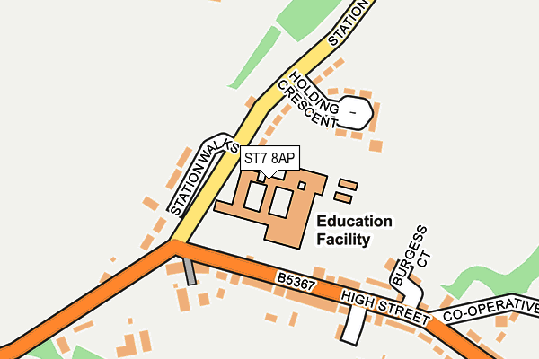
ST7 8AP is located in the Audley electoral ward, within the local authority district of Newcastle-under-Lyme and the English Parliamentary constituency of Newcastle-under-Lyme. The Sub Integrated Care Board (ICB) Location is NHS Staffordshire and Stoke-on-Trent ICB - 05G and the police force is Staffordshire. This postcode has been in use since January 1980.


GetTheData
Source: OS OpenMap – Local (Ordnance Survey)
Source: OS VectorMap District (Ordnance Survey)
Licence: Open Government Licence (requires attribution)
| Easting | 379673 |
| Northing | 349231 |
| Latitude | 53.039961 |
| Longitude | -2.304611 |
GetTheData
Source: Open Postcode Geo
Licence: Open Government Licence
| Country | England |
| Postcode District | ST7 |
| ➜ ST7 open data dashboard ➜ See where ST7 is on a map ➜ Where is Halmer End? | |
GetTheData
Source: Land Registry Price Paid Data
Licence: Open Government Licence
Elevation or altitude of ST7 8AP as distance above sea level:
| Metres | Feet | |
|---|---|---|
| Elevation | 140m | 459ft |
Elevation is measured from the approximate centre of the postcode, to the nearest point on an OS contour line from OS Terrain 50, which has contour spacing of ten vertical metres.
➜ How high above sea level am I? Find the elevation of your current position using your device's GPS.
GetTheData
Source: Open Postcode Elevation
Licence: Open Government Licence
| Ward | Audley |
| Constituency | Newcastle-under-lyme |
GetTheData
Source: ONS Postcode Database
Licence: Open Government Licence
| June 2022 | Criminal damage and arson | On or near Station Walks | 83m |
| June 2022 | Violence and sexual offences | On or near Station Walks | 83m |
| June 2022 | Violence and sexual offences | On or near Station Walks | 83m |
| ➜ Get more crime data in our Crime section | |||
GetTheData
Source: data.police.uk
Licence: Open Government Licence
| Holding Crescent (Station Road) | Halmer End | 78m |
| Sir Thomas Boughey School (High St) | Halmer End | 103m |
| Holding Crescent (Station Road) | Halmer End | 105m |
| Sir Thomas Boughey School (High St) | Halmer End | 105m |
| Harrison Close (High Street) | Halmer End | 250m |
GetTheData
Source: NaPTAN
Licence: Open Government Licence
GetTheData
Source: ONS Postcode Database
Licence: Open Government Licence


➜ Get more ratings from the Food Standards Agency
GetTheData
Source: Food Standards Agency
Licence: FSA terms & conditions
| Last Collection | |||
|---|---|---|---|
| Location | Mon-Fri | Sat | Distance |
| Scott Hay | 16:00 | 09:30 | 3,038m |
| Quarry Bank | 17:00 | 09:00 | 3,235m |
| Station Road | 17:00 | 09:00 | 3,586m |
GetTheData
Source: Dracos
Licence: Creative Commons Attribution-ShareAlike
| Facility | Distance |
|---|---|
| Sir Thomas Boughey High School Station Road, Halmer End, Stoke-on-trent Grass Pitches, Sports Hall | 0m |
| Halmer End Cic Wesley Place, Wesley Place, Alsagers Bank, Newcastle Under Lyme Grass Pitches | 292m |
| Alsagers Bank Sports Ground Alsagers Bank, Stoke-on-trent Grass Pitches | 1.2km |
GetTheData
Source: Active Places
Licence: Open Government Licence
| School | Phase of Education | Distance |
|---|---|---|
| Sir Thomas Boughey Academy Station Road, Halmer End, Stoke-on-Trent, ST7 8AP | Secondary | 3m |
| Alsagers Bank Primary Academy The Drive, Alsagers Bank, Stoke-on-Trent, ST7 8BB | Primary | 1.1km |
| Wood Lane Primary School Wood Lane, Bignall End, Stoke-on-Trent, ST7 8PH | Primary | 1.6km |
GetTheData
Source: Edubase
Licence: Open Government Licence
The below table lists the International Territorial Level (ITL) codes (formerly Nomenclature of Territorial Units for Statistics (NUTS) codes) and Local Administrative Units (LAU) codes for ST7 8AP:
| ITL 1 Code | Name |
|---|---|
| TLG | West Midlands (England) |
| ITL 2 Code | Name |
| TLG2 | Shropshire and Staffordshire |
| ITL 3 Code | Name |
| TLG24 | Staffordshire CC |
| LAU 1 Code | Name |
| E07000195 | Newcastle-under-Lyme |
GetTheData
Source: ONS Postcode Directory
Licence: Open Government Licence
The below table lists the Census Output Area (OA), Lower Layer Super Output Area (LSOA), and Middle Layer Super Output Area (MSOA) for ST7 8AP:
| Code | Name | |
|---|---|---|
| OA | E00150600 | |
| LSOA | E01029556 | Newcastle-under-Lyme 005E |
| MSOA | E02006162 | Newcastle-under-Lyme 005 |
GetTheData
Source: ONS Postcode Directory
Licence: Open Government Licence
| ST7 8AS | Holding Crescent | 97m |
| ST7 8AG | High Street | 122m |
| ST7 8AU | Station Walks | 133m |
| ST7 8AR | Station Road | 154m |
| ST7 8AQ | Wesley Place | 186m |
| ST7 8AF | High Street | 231m |
| ST7 8AH | Shraley Brook Road | 270m |
| ST7 8AE | Harrison Close | 329m |
| ST7 8BL | Cooperative Lane | 329m |
| ST7 8BY | Minnie Close | 344m |
GetTheData
Source: Open Postcode Geo; Land Registry Price Paid Data
Licence: Open Government Licence