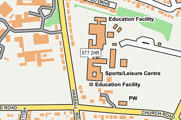
ST7 2HR is located in the Alsager electoral ward, within the unitary authority of Cheshire East and the English Parliamentary constituency of Congleton. The Sub Integrated Care Board (ICB) Location is NHS Cheshire and Merseyside ICB - 27D and the police force is Cheshire. This postcode has been in use since January 1980.


GetTheData
Source: OS OpenMap – Local (Ordnance Survey)
Source: OS VectorMap District (Ordnance Survey)
Licence: Open Government Licence (requires attribution)
| Easting | 378787 |
| Northing | 355808 |
| Latitude | 53.099046 |
| Longitude | -2.318261 |
GetTheData
Source: Open Postcode Geo
Licence: Open Government Licence
| Country | England |
| Postcode District | ST7 |
| ➜ ST7 open data dashboard ➜ See where ST7 is on a map ➜ Where is Alsager? | |
GetTheData
Source: Land Registry Price Paid Data
Licence: Open Government Licence
Elevation or altitude of ST7 2HR as distance above sea level:
| Metres | Feet | |
|---|---|---|
| Elevation | 90m | 295ft |
Elevation is measured from the approximate centre of the postcode, to the nearest point on an OS contour line from OS Terrain 50, which has contour spacing of ten vertical metres.
➜ How high above sea level am I? Find the elevation of your current position using your device's GPS.
GetTheData
Source: Open Postcode Elevation
Licence: Open Government Licence
| Ward | Alsager |
| Constituency | Congleton |
GetTheData
Source: ONS Postcode Database
Licence: Open Government Licence
| June 2022 | Anti-social behaviour | On or near College Road | 362m |
| June 2022 | Anti-social behaviour | On or near Sunnyside | 455m |
| June 2022 | Anti-social behaviour | On or near Sunnyside | 455m |
| ➜ Get more crime data in our Crime section | |||
GetTheData
Source: data.police.uk
Licence: Open Government Licence
| Alsager School (Hassall Road) | Alsager | 66m |
| Alsager Campus (Hassall Road) | Alsager | 169m |
| Alsager High School (Off Hassall Road) | Alsager | 183m |
| Church Road (Hassall Road) | Alsager | 259m |
| Dunnocksfold Road | Alsager | 317m |
| Alsager Station | 1.5km |
| Kidsgrove Station | 5.1km |
GetTheData
Source: NaPTAN
Licence: Open Government Licence
GetTheData
Source: ONS Postcode Database
Licence: Open Government Licence


➜ Get more ratings from the Food Standards Agency
GetTheData
Source: Food Standards Agency
Licence: FSA terms & conditions
| Last Collection | |||
|---|---|---|---|
| Location | Mon-Fri | Sat | Distance |
| The Pet Shop | 17:15 | 10:30 | 327m |
| Crewe Road | 16:30 | 10:30 | 642m |
| Alsager Post Office | 17:30 | 11:30 | 1,757m |
GetTheData
Source: Dracos
Licence: Creative Commons Attribution-ShareAlike
| Facility | Distance |
|---|---|
| Alsager Leisure Centre Hassall Road, Alsager, Stoke-on-trent Sports Hall, Swimming Pool, Health and Fitness Gym, Artificial Grass Pitch, Grass Pitches, Studio, Squash Courts | 106m |
| Alsager Outdoor Pitches (Closed) Hassall Road, Alsager, Stoke-on-trent Grass Pitches, Health and Fitness Gym, Sports Hall, Swimming Pool, Artificial Grass Pitch | 255m |
| Alsager Sports Hub Dunnocksfold Road, Alsager Artificial Grass Pitch, Grass Pitches | 386m |
GetTheData
Source: Active Places
Licence: Open Government Licence
| School | Phase of Education | Distance |
|---|---|---|
| Alsager School Hassall Road, Alsager, Stoke-on-Trent, ST7 2HR | Secondary | 1m |
| Pikemere School Pikemere Road, Cheshire East, Alsager, ST7 2SW | Primary | 577m |
| Cranberry Academy Cranberry Lane, Alsager, Cranberry Academy, ST7 2LE | Primary | 644m |
GetTheData
Source: Edubase
Licence: Open Government Licence
The below table lists the International Territorial Level (ITL) codes (formerly Nomenclature of Territorial Units for Statistics (NUTS) codes) and Local Administrative Units (LAU) codes for ST7 2HR:
| ITL 1 Code | Name |
|---|---|
| TLD | North West (England) |
| ITL 2 Code | Name |
| TLD6 | Cheshire |
| ITL 3 Code | Name |
| TLD62 | Cheshire East |
| LAU 1 Code | Name |
| E06000049 | Cheshire East |
GetTheData
Source: ONS Postcode Directory
Licence: Open Government Licence
The below table lists the Census Output Area (OA), Lower Layer Super Output Area (LSOA), and Middle Layer Super Output Area (MSOA) for ST7 2HR:
| Code | Name | |
|---|---|---|
| OA | E00092762 | |
| LSOA | E01018386 | Cheshire East 042A |
| MSOA | E02003824 | Cheshire East 042 |
GetTheData
Source: ONS Postcode Directory
Licence: Open Government Licence
| ST7 2HJ | Hassall Road | 98m |
| ST7 2GS | Charles Tryon Court | 115m |
| ST7 2HP | Hassall Road | 122m |
| ST7 2HW | Heathwood Drive | 185m |
| ST7 2HS | Church Road | 202m |
| ST7 2SY | Harpur Crescent | 226m |
| ST7 2HG | Beechwood Drive | 260m |
| ST7 2SX | Harpur Crescent | 278m |
| ST7 2YN | Parish Close | 289m |
| ST7 2HH | Hassall Road | 297m |
GetTheData
Source: Open Postcode Geo; Land Registry Price Paid Data
Licence: Open Government Licence