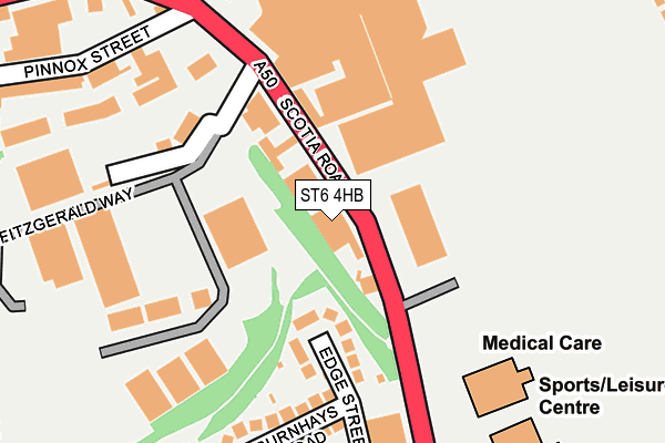
ST6 4HB is located in the Little Chell & Stanfield electoral ward, within the unitary authority of Stoke-on-Trent and the English Parliamentary constituency of Stoke-on-Trent North. The Sub Integrated Care Board (ICB) Location is NHS Staffordshire and Stoke-on-Trent ICB - 05W and the police force is Staffordshire. This postcode has been in use since January 1980.


GetTheData
Source: OS OpenMap – Local (Ordnance Survey)
Source: OS VectorMap District (Ordnance Survey)
Licence: Open Government Licence (requires attribution)
| Easting | 386590 |
| Northing | 350752 |
| Latitude | 53.053870 |
| Longitude | -2.201515 |
GetTheData
Source: Open Postcode Geo
Licence: Open Government Licence
| Country | England |
| Postcode District | ST6 |
➜ See where ST6 is on a map ➜ Where is Stoke-on-Trent? | |
GetTheData
Source: Land Registry Price Paid Data
Licence: Open Government Licence
Elevation or altitude of ST6 4HB as distance above sea level:
| Metres | Feet | |
|---|---|---|
| Elevation | 140m | 459ft |
Elevation is measured from the approximate centre of the postcode, to the nearest point on an OS contour line from OS Terrain 50, which has contour spacing of ten vertical metres.
➜ How high above sea level am I? Find the elevation of your current position using your device's GPS.
GetTheData
Source: Open Postcode Elevation
Licence: Open Government Licence
| Ward | Little Chell & Stanfield |
| Constituency | Stoke-on-trent North |
GetTheData
Source: ONS Postcode Database
Licence: Open Government Licence
| Dudson's Factory (Scotia Road) | Burslem | 57m |
| Dudson's Factory (Scotia Road) | Burslem | 102m |
| Evans Street (Scotia Road) | Burslem | 187m |
| Evans Street (Scotia Road) | Burslem | 345m |
| Scotia Road (Williamson Street) | Tunstall | 349m |
| Longport Station | 1.7km |
| Kidsgrove Station | 4.7km |
GetTheData
Source: NaPTAN
Licence: Open Government Licence
GetTheData
Source: ONS Postcode Database
Licence: Open Government Licence


➜ Get more ratings from the Food Standards Agency
GetTheData
Source: Food Standards Agency
Licence: FSA terms & conditions
| Last Collection | |||
|---|---|---|---|
| Location | Mon-Fri | Sat | Distance |
| Scotia Road | 17:00 | 09:30 | 475m |
| Browhills Road | 18:00 | 10:45 | 602m |
| Victoria Park Road | 18:00 | 10:30 | 667m |
GetTheData
Source: Dracos
Licence: Creative Commons Attribution-ShareAlike
| Risk of ST6 4HB flooding from rivers and sea | Medium |
| ➜ ST6 4HB flood map | |
GetTheData
Source: Open Flood Risk by Postcode
Licence: Open Government Licence
The below table lists the International Territorial Level (ITL) codes (formerly Nomenclature of Territorial Units for Statistics (NUTS) codes) and Local Administrative Units (LAU) codes for ST6 4HB:
| ITL 1 Code | Name |
|---|---|
| TLG | West Midlands (England) |
| ITL 2 Code | Name |
| TLG2 | Shropshire and Staffordshire |
| ITL 3 Code | Name |
| TLG23 | Stoke-on-Trent |
| LAU 1 Code | Name |
| E06000021 | Stoke-on-Trent |
GetTheData
Source: ONS Postcode Directory
Licence: Open Government Licence
The below table lists the Census Output Area (OA), Lower Layer Super Output Area (LSOA), and Middle Layer Super Output Area (MSOA) for ST6 4HB:
| Code | Name | |
|---|---|---|
| OA | E00071979 | |
| LSOA | E01014252 | Stoke-on-Trent 009D |
| MSOA | E02002959 | Stoke-on-Trent 009 |
GetTheData
Source: ONS Postcode Directory
Licence: Open Government Licence
| ST6 4HQ | Edge Street | 102m |
| ST6 4HN | Fitzgerald Way | 179m |
| ST6 4HH | Burnhays Road | 204m |
| ST6 4EZ | Scotia Road | 226m |
| ST6 4HJ | Edge Street | 252m |
| ST6 4HW | Herd Street | 260m |
| ST6 6AD | Pinnox Street | 281m |
| ST6 4HL | Chatterley Street | 305m |
| ST6 4HP | Evans Street | 307m |
| ST6 4DZ | Gallimore Close | 315m |
GetTheData
Source: Open Postcode Geo; Land Registry Price Paid Data
Licence: Open Government Licence