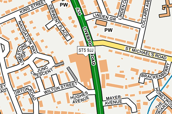
ST5 9JJ is located in the Cross Heath electoral ward, within the local authority district of Newcastle-under-Lyme and the English Parliamentary constituency of Newcastle-under-Lyme. The Sub Integrated Care Board (ICB) Location is NHS Staffordshire and Stoke-on-Trent ICB - 05G and the police force is Staffordshire. This postcode has been in use since December 1997.


GetTheData
Source: OS OpenMap – Local (Ordnance Survey)
Source: OS VectorMap District (Ordnance Survey)
Licence: Open Government Licence (requires attribution)
| Easting | 384577 |
| Northing | 347108 |
| Latitude | 53.021042 |
| Longitude | -2.231370 |
GetTheData
Source: Open Postcode Geo
Licence: Open Government Licence
| Country | England |
| Postcode District | ST5 |
➜ See where ST5 is on a map ➜ Where is Newcastle-under-Lyme? | |
GetTheData
Source: Land Registry Price Paid Data
Licence: Open Government Licence
Elevation or altitude of ST5 9JJ as distance above sea level:
| Metres | Feet | |
|---|---|---|
| Elevation | 140m | 459ft |
Elevation is measured from the approximate centre of the postcode, to the nearest point on an OS contour line from OS Terrain 50, which has contour spacing of ten vertical metres.
➜ How high above sea level am I? Find the elevation of your current position using your device's GPS.
GetTheData
Source: Open Postcode Elevation
Licence: Open Government Licence
| Ward | Cross Heath |
| Constituency | Newcastle-under-lyme |
GetTheData
Source: ONS Postcode Database
Licence: Open Government Licence
| St Michaels Road (Liverpool Rd) | Cross Heath | 38m |
| St Michaels Road (Liverpool Rd) | Cross Heath | 124m |
| Hassam Avenue (Liverpool Road) | Cross Heath | 178m |
| Hassam Avenue (Liverpool Rd) | Cross Heath | 290m |
| Shops (Liverpool Rd) | Cross Heath | 358m |
| Longport Station | 2.5km |
| Stoke-on-Trent Station | 3.7km |
GetTheData
Source: NaPTAN
Licence: Open Government Licence
GetTheData
Source: ONS Postcode Database
Licence: Open Government Licence


➜ Get more ratings from the Food Standards Agency
GetTheData
Source: Food Standards Agency
Licence: FSA terms & conditions
| Last Collection | |||
|---|---|---|---|
| Location | Mon-Fri | Sat | Distance |
| Sidmouth Avenue | 17:30 | 11:45 | 883m |
| Newcastle Post Office | 17:30 | 12:30 | 998m |
| May Avenue | 18:00 | 09:15 | 1,032m |
GetTheData
Source: Dracos
Licence: Creative Commons Attribution-ShareAlike
The below table lists the International Territorial Level (ITL) codes (formerly Nomenclature of Territorial Units for Statistics (NUTS) codes) and Local Administrative Units (LAU) codes for ST5 9JJ:
| ITL 1 Code | Name |
|---|---|
| TLG | West Midlands (England) |
| ITL 2 Code | Name |
| TLG2 | Shropshire and Staffordshire |
| ITL 3 Code | Name |
| TLG24 | Staffordshire CC |
| LAU 1 Code | Name |
| E07000195 | Newcastle-under-Lyme |
GetTheData
Source: ONS Postcode Directory
Licence: Open Government Licence
The below table lists the Census Output Area (OA), Lower Layer Super Output Area (LSOA), and Middle Layer Super Output Area (MSOA) for ST5 9JJ:
| Code | Name | |
|---|---|---|
| OA | E00150579 | |
| LSOA | E01029553 | Newcastle-under-Lyme 010A |
| MSOA | E02006167 | Newcastle-under-Lyme 010 |
GetTheData
Source: ONS Postcode Directory
Licence: Open Government Licence
| ST5 9ED | Liverpool Road | 64m |
| ST5 9HD | Liverpool Road | 113m |
| ST5 9LN | St Michaels Road | 124m |
| ST5 9GZ | Junction Crescent | 132m |
| ST5 9HG | Derwent Place | 137m |
| ST5 9HA | Hughes Avenue | 160m |
| ST5 9LJ | Linden Grove | 167m |
| ST5 9HH | Navigation Way | 178m |
| ST5 9HS | The Gardens | 189m |
| ST5 9HF | Liverpool Road | 189m |
GetTheData
Source: Open Postcode Geo; Land Registry Price Paid Data
Licence: Open Government Licence