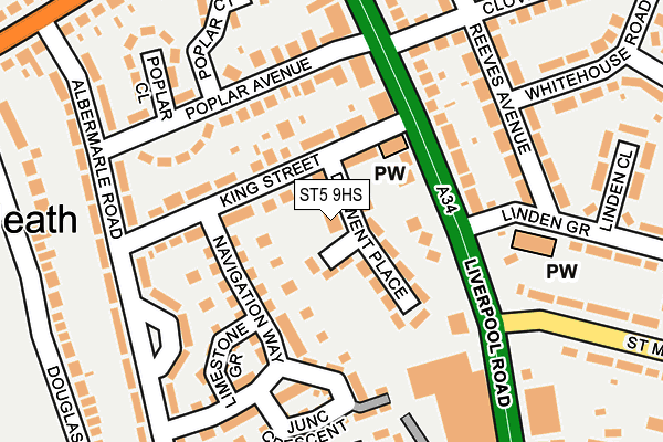
ST5 9HS lies on The Gardens in Newcastle. ST5 9HS is located in the Cross Heath electoral ward, within the local authority district of Newcastle-under-Lyme and the English Parliamentary constituency of Newcastle-under-Lyme. The Sub Integrated Care Board (ICB) Location is NHS Staffordshire and Stoke-on-Trent ICB - 05G and the police force is Staffordshire. This postcode has been in use since March 2008.


GetTheData
Source: OS OpenMap – Local (Ordnance Survey)
Source: OS VectorMap District (Ordnance Survey)
Licence: Open Government Licence (requires attribution)
| Easting | 384449 |
| Northing | 347247 |
| Latitude | 53.022305 |
| Longitude | -2.233285 |
GetTheData
Source: Open Postcode Geo
Licence: Open Government Licence
| Street | The Gardens |
| Town/City | Newcastle |
| Country | England |
| Postcode District | ST5 |
➜ See where ST5 is on a map ➜ Where is Newcastle-under-Lyme? | |
GetTheData
Source: Land Registry Price Paid Data
Licence: Open Government Licence
Elevation or altitude of ST5 9HS as distance above sea level:
| Metres | Feet | |
|---|---|---|
| Elevation | 140m | 459ft |
Elevation is measured from the approximate centre of the postcode, to the nearest point on an OS contour line from OS Terrain 50, which has contour spacing of ten vertical metres.
➜ How high above sea level am I? Find the elevation of your current position using your device's GPS.
GetTheData
Source: Open Postcode Elevation
Licence: Open Government Licence
| Ward | Cross Heath |
| Constituency | Newcastle-under-lyme |
GetTheData
Source: ONS Postcode Database
Licence: Open Government Licence
2, THE GARDENS, NEWCASTLE, ST5 9HS 2023 27 JAN £170,000 |
2, THE GARDENS, NEWCASTLE, ST5 9HS 2021 25 JUN £146,000 |
2, THE GARDENS, NEWCASTLE, ST5 9HS 2006 1 DEC £130,750 |
➜ Newcastle-under-Lyme house prices
GetTheData
Source: HM Land Registry Price Paid Data
Licence: Contains HM Land Registry data © Crown copyright and database right 2025. This data is licensed under the Open Government Licence v3.0.
| St Michaels Road (Liverpool Rd) | Cross Heath | 130m |
| Shops (Liverpool Rd) | Cross Heath | 199m |
| Shops (Liverpool Rd) | Cross Heath | 219m |
| St Michaels Road (Liverpool Rd) | Cross Heath | 226m |
| Hassam Avenue (Liverpool Road) | Cross Heath | 352m |
| Longport Station | 2.5km |
| Stoke-on-Trent Station | 3.9km |
GetTheData
Source: NaPTAN
Licence: Open Government Licence
| Percentage of properties with Next Generation Access | 100.0% |
| Percentage of properties with Superfast Broadband | 100.0% |
| Percentage of properties with Ultrafast Broadband | 100.0% |
| Percentage of properties with Full Fibre Broadband | 0.0% |
Superfast Broadband is between 30Mbps and 300Mbps
Ultrafast Broadband is > 300Mbps
| Percentage of properties unable to receive 2Mbps | 0.0% |
| Percentage of properties unable to receive 5Mbps | 0.0% |
| Percentage of properties unable to receive 10Mbps | 0.0% |
| Percentage of properties unable to receive 30Mbps | 0.0% |
GetTheData
Source: Ofcom
Licence: Ofcom Terms of Use (requires attribution)
GetTheData
Source: ONS Postcode Database
Licence: Open Government Licence


➜ Get more ratings from the Food Standards Agency
GetTheData
Source: Food Standards Agency
Licence: FSA terms & conditions
| Last Collection | |||
|---|---|---|---|
| Location | Mon-Fri | Sat | Distance |
| Sidmouth Avenue | 17:30 | 11:45 | 1,071m |
| May Avenue | 18:00 | 09:15 | 1,111m |
| Newcastle Post Office | 17:30 | 12:30 | 1,169m |
GetTheData
Source: Dracos
Licence: Creative Commons Attribution-ShareAlike
The below table lists the International Territorial Level (ITL) codes (formerly Nomenclature of Territorial Units for Statistics (NUTS) codes) and Local Administrative Units (LAU) codes for ST5 9HS:
| ITL 1 Code | Name |
|---|---|
| TLG | West Midlands (England) |
| ITL 2 Code | Name |
| TLG2 | Shropshire and Staffordshire |
| ITL 3 Code | Name |
| TLG24 | Staffordshire CC |
| LAU 1 Code | Name |
| E07000195 | Newcastle-under-Lyme |
GetTheData
Source: ONS Postcode Directory
Licence: Open Government Licence
The below table lists the Census Output Area (OA), Lower Layer Super Output Area (LSOA), and Middle Layer Super Output Area (MSOA) for ST5 9HS:
| Code | Name | |
|---|---|---|
| OA | E00150579 | |
| LSOA | E01029553 | Newcastle-under-Lyme 010A |
| MSOA | E02006167 | Newcastle-under-Lyme 010 |
GetTheData
Source: ONS Postcode Directory
Licence: Open Government Licence
| ST5 9HG | Derwent Place | 53m |
| ST5 9HQ | King Street | 59m |
| ST5 9HF | Liverpool Road | 79m |
| ST5 9HH | Navigation Way | 104m |
| ST5 9HJ | Navigation Way | 120m |
| ST5 9HR | Poplar Avenue | 129m |
| ST5 9EB | Liverpool Road | 132m |
| ST5 9GY | Limestone Grove | 153m |
| ST5 9GZ | Junction Crescent | 161m |
| ST5 9BG | Albemarle Road | 179m |
GetTheData
Source: Open Postcode Geo; Land Registry Price Paid Data
Licence: Open Government Licence