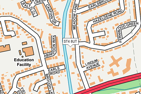
ST4 8UT is located in the Hanford, Newstead & Trentham electoral ward, within the unitary authority of Stoke-on-Trent and the English Parliamentary constituency of Stoke-on-Trent South. The Sub Integrated Care Board (ICB) Location is NHS Staffordshire and Stoke-on-Trent ICB - 05W and the police force is Staffordshire. This postcode has been in use since March 1982.


GetTheData
Source: OS OpenMap – Local (Ordnance Survey)
Source: OS VectorMap District (Ordnance Survey)
Licence: Open Government Licence (requires attribution)
| Easting | 388033 |
| Northing | 341195 |
| Latitude | 52.967995 |
| Longitude | -2.179628 |
GetTheData
Source: Open Postcode Geo
Licence: Open Government Licence
| Country | England |
| Postcode District | ST4 |
➜ See where ST4 is on a map ➜ Where is Stoke-on-Trent? | |
GetTheData
Source: Land Registry Price Paid Data
Licence: Open Government Licence
Elevation or altitude of ST4 8UT as distance above sea level:
| Metres | Feet | |
|---|---|---|
| Elevation | 110m | 361ft |
Elevation is measured from the approximate centre of the postcode, to the nearest point on an OS contour line from OS Terrain 50, which has contour spacing of ten vertical metres.
➜ How high above sea level am I? Find the elevation of your current position using your device's GPS.
GetTheData
Source: Open Postcode Elevation
Licence: Open Government Licence
| Ward | Hanford, Newstead & Trentham |
| Constituency | Stoke-on-trent South |
GetTheData
Source: ONS Postcode Database
Licence: Open Government Licence
| Brough Lane | Trentham | 183m |
| Newpark Plantation (Longton Road) | Trentham | 213m |
| Newpark Plantation (Longton Road) | Trentham | 238m |
| Trentham Hotel (Longton Road) | Trentham | 324m |
| Trentham Hotel (Longton Road) | Trentham | 349m |
| Wedgwood Station | 2km |
| Barlaston Station | 2.9km |
| Longton Station | 3.8km |
GetTheData
Source: NaPTAN
Licence: Open Government Licence
GetTheData
Source: ONS Postcode Database
Licence: Open Government Licence


➜ Get more ratings from the Food Standards Agency
GetTheData
Source: Food Standards Agency
Licence: FSA terms & conditions
| Last Collection | |||
|---|---|---|---|
| Location | Mon-Fri | Sat | Distance |
| Hem Heath Post Office | 17:15 | 12:00 | 159m |
| Pacific Road | 17:30 | 09:30 | 415m |
| Burrington Drive | 18:00 | 09:15 | 719m |
GetTheData
Source: Dracos
Licence: Creative Commons Attribution-ShareAlike
| Risk of ST4 8UT flooding from rivers and sea | Medium |
| ➜ ST4 8UT flood map | |
GetTheData
Source: Open Flood Risk by Postcode
Licence: Open Government Licence
The below table lists the International Territorial Level (ITL) codes (formerly Nomenclature of Territorial Units for Statistics (NUTS) codes) and Local Administrative Units (LAU) codes for ST4 8UT:
| ITL 1 Code | Name |
|---|---|
| TLG | West Midlands (England) |
| ITL 2 Code | Name |
| TLG2 | Shropshire and Staffordshire |
| ITL 3 Code | Name |
| TLG23 | Stoke-on-Trent |
| LAU 1 Code | Name |
| E06000021 | Stoke-on-Trent |
GetTheData
Source: ONS Postcode Directory
Licence: Open Government Licence
The below table lists the Census Output Area (OA), Lower Layer Super Output Area (LSOA), and Middle Layer Super Output Area (MSOA) for ST4 8UT:
| Code | Name | |
|---|---|---|
| OA | E00072473 | |
| LSOA | E01014351 | Stoke-on-Trent 034C |
| MSOA | E02002984 | Stoke-on-Trent 034 |
GetTheData
Source: ONS Postcode Directory
Licence: Open Government Licence
| ST4 8DH | Meadow Lane | 87m |
| ST4 8DX | Abingdon Way | 95m |
| ST4 8DG | Earls Road | 97m |
| ST4 8DR | Lindum Avenue | 128m |
| ST4 8DW | Hampstead Grove | 151m |
| ST4 8RX | Caspian Grove | 176m |
| ST4 8DS | Longton Road | 179m |
| ST4 8DN | Hazeldene Road | 188m |
| ST4 8DQ | Longton Road | 190m |
| ST4 8BX | Brough Lane | 191m |
GetTheData
Source: Open Postcode Geo; Land Registry Price Paid Data
Licence: Open Government Licence