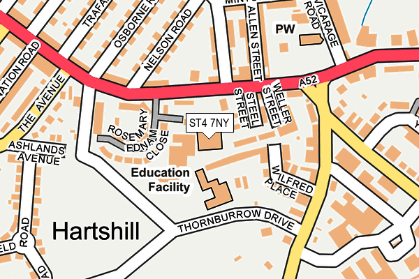
ST4 7NY is located in the Basford & Hartshill electoral ward, within the unitary authority of Stoke-on-Trent and the English Parliamentary constituency of Stoke-on-Trent Central. The Sub Integrated Care Board (ICB) Location is NHS Staffordshire and Stoke-on-Trent ICB - 05W and the police force is Staffordshire. This postcode has been in use since January 1980.


GetTheData
Source: OS OpenMap – Local (Ordnance Survey)
Source: OS VectorMap District (Ordnance Survey)
Licence: Open Government Licence (requires attribution)
| Easting | 386399 |
| Northing | 345690 |
| Latitude | 53.008345 |
| Longitude | -2.204149 |
GetTheData
Source: Open Postcode Geo
Licence: Open Government Licence
| Country | England |
| Postcode District | ST4 |
| ➜ ST4 open data dashboard ➜ See where ST4 is on a map ➜ Where is Stoke-on-Trent? | |
GetTheData
Source: Land Registry Price Paid Data
Licence: Open Government Licence
Elevation or altitude of ST4 7NY as distance above sea level:
| Metres | Feet | |
|---|---|---|
| Elevation | 150m | 492ft |
Elevation is measured from the approximate centre of the postcode, to the nearest point on an OS contour line from OS Terrain 50, which has contour spacing of ten vertical metres.
➜ How high above sea level am I? Find the elevation of your current position using your device's GPS.
GetTheData
Source: Open Postcode Elevation
Licence: Open Government Licence
| Ward | Basford & Hartshill |
| Constituency | Stoke-on-trent Central |
GetTheData
Source: ONS Postcode Database
Licence: Open Government Licence
| October 2023 | Bicycle theft | On or near Steel Street | 78m |
| August 2023 | Bicycle theft | On or near Steel Street | 78m |
| August 2023 | Violence and sexual offences | On or near Steel Street | 78m |
| ➜ Get more crime data in our Crime section | |||
GetTheData
Source: data.police.uk
Licence: Open Government Licence
| Nelson Road (Hartshill Road) | Hartshill | 84m |
| Nelson Road (Hartshill Road) | Hartshill | 117m |
| Holy Trinity Church (Hartshill Road) | Hartshill | 131m |
| Queens Road (Princes Road) | Hartshill | 173m |
| Holy Trinity Church (Hartshill Road) | Hartshill | 197m |
| Stoke-on-Trent Station | 1.6km |
| Longport Station | 3.8km |
| Longton Station | 4.9km |
GetTheData
Source: NaPTAN
Licence: Open Government Licence
GetTheData
Source: ONS Postcode Database
Licence: Open Government Licence

➜ Get more ratings from the Food Standards Agency
GetTheData
Source: Food Standards Agency
Licence: FSA terms & conditions
| Last Collection | |||
|---|---|---|---|
| Location | Mon-Fri | Sat | Distance |
| The Avenue | 17:30 | 09:45 | 252m |
| Newcastle Lane | 17:30 | 09:30 | 859m |
| Basford Post Office | 17:00 | 11:45 | 970m |
GetTheData
Source: Dracos
Licence: Creative Commons Attribution-ShareAlike
| Facility | Distance |
|---|---|
| St Peters Academy (Closed) Queens Road, Stoke-on-trent Sports Hall, Studio, Artificial Grass Pitch | 549m |
| St Dominics Independent Junior School (Closed) Hartshill Road, Stoke-on-trent Sports Hall, Grass Pitches, Swimming Pool | 628m |
| The Willows Primary School Greatbatch Avenue, Greatbatch Avenue, Stoke-on-trent Grass Pitches | 667m |
GetTheData
Source: Active Places
Licence: Open Government Licence
| School | Phase of Education | Distance |
|---|---|---|
| St Thomas Aquinas Catholic Primary School North Street, Stoke-on-Trent, ST4 7DG | Primary | 531m |
| Harpfield Primary Academy Palmers Green, Hartshill, Stoke-on-Trent, ST4 6AP | Primary | 681m |
| The Willows Primary School Greatbatch Avenue, Penkhull, Stoke-on-Trent, ST4 7JY | Primary | 698m |
GetTheData
Source: Edubase
Licence: Open Government Licence
The below table lists the International Territorial Level (ITL) codes (formerly Nomenclature of Territorial Units for Statistics (NUTS) codes) and Local Administrative Units (LAU) codes for ST4 7NY:
| ITL 1 Code | Name |
|---|---|
| TLG | West Midlands (England) |
| ITL 2 Code | Name |
| TLG2 | Shropshire and Staffordshire |
| ITL 3 Code | Name |
| TLG23 | Stoke-on-Trent |
| LAU 1 Code | Name |
| E06000021 | Stoke-on-Trent |
GetTheData
Source: ONS Postcode Directory
Licence: Open Government Licence
The below table lists the Census Output Area (OA), Lower Layer Super Output Area (LSOA), and Middle Layer Super Output Area (MSOA) for ST4 7NY:
| Code | Name | |
|---|---|---|
| OA | E00072166 | |
| LSOA | E01014290 | Stoke-on-Trent 018C |
| MSOA | E02002968 | Stoke-on-Trent 018 |
GetTheData
Source: ONS Postcode Directory
Licence: Open Government Licence
| ST4 7NU | Forsyth Close | 35m |
| ST4 7NR | Hartshill Road | 53m |
| ST4 7NS | Steel Street | 65m |
| ST4 7NG | Rosemary Ednam Close | 99m |
| ST4 7NX | Hartshill Road | 104m |
| ST4 7NJ | Hartshill Road | 109m |
| ST4 7LL | Wilfred Place | 113m |
| ST4 7JG | Princes Road | 145m |
| ST4 7NT | Cumming Street | 148m |
| ST4 7LJ | Queens Road | 150m |
GetTheData
Source: Open Postcode Geo; Land Registry Price Paid Data
Licence: Open Government Licence