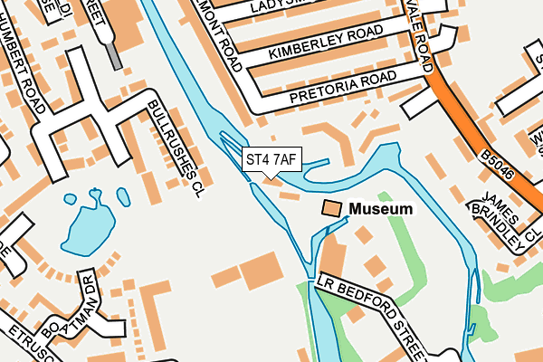
ST4 7AF is located in the Etruria & Hanley electoral ward, within the unitary authority of Stoke-on-Trent and the English Parliamentary constituency of Stoke-on-Trent Central. The Sub Integrated Care Board (ICB) Location is NHS Staffordshire and Stoke-on-Trent ICB - 05W and the police force is Staffordshire. This postcode has been in use since January 1980.


GetTheData
Source: OS OpenMap – Local (Ordnance Survey)
Source: OS VectorMap District (Ordnance Survey)
Licence: Open Government Licence (requires attribution)
| Easting | 387223 |
| Northing | 346884 |
| Latitude | 53.019116 |
| Longitude | -2.191915 |
GetTheData
Source: Open Postcode Geo
Licence: Open Government Licence
| Country | England |
| Postcode District | ST4 |
| ➜ ST4 open data dashboard ➜ See where ST4 is on a map ➜ Where is Stoke-on-Trent? | |
GetTheData
Source: Land Registry Price Paid Data
Licence: Open Government Licence
Elevation or altitude of ST4 7AF as distance above sea level:
| Metres | Feet | |
|---|---|---|
| Elevation | 120m | 394ft |
Elevation is measured from the approximate centre of the postcode, to the nearest point on an OS contour line from OS Terrain 50, which has contour spacing of ten vertical metres.
➜ How high above sea level am I? Find the elevation of your current position using your device's GPS.
GetTheData
Source: Open Postcode Elevation
Licence: Open Government Licence
| Ward | Etruria & Hanley |
| Constituency | Stoke-on-trent Central |
GetTheData
Source: ONS Postcode Database
Licence: Open Government Licence
| January 2024 | Other crime | On or near Joanhurst Crescent | 342m |
| October 2023 | Violence and sexual offences | On or near Joanhurst Crescent | 342m |
| January 2023 | Violence and sexual offences | On or near Joanhurst Crescent | 342m |
| ➜ Get more crime data in our Crime section | |||
GetTheData
Source: data.police.uk
Licence: Open Government Licence
| Cemetery Road (Shelton New Road) | Shelton | 364m |
| Clough Street Bottom (Clough Street) | Hanley | 366m |
| Cemetery Road (Shelton New Road) | Shelton | 372m |
| Etruscan Street (Shelton New Road) | Shelton | 386m |
| Clough Street Bottom (Clough Street) | Hanley | 392m |
| Stoke-on-Trent Station | 1.4km |
| Longport Station | 3km |
| Longton Station | 4.9km |
GetTheData
Source: NaPTAN
Licence: Open Government Licence
GetTheData
Source: ONS Postcode Database
Licence: Open Government Licence


➜ Get more ratings from the Food Standards Agency
GetTheData
Source: Food Standards Agency
Licence: FSA terms & conditions
| Last Collection | |||
|---|---|---|---|
| Location | Mon-Fri | Sat | Distance |
| Etruria Vale Road | 17:30 | 11:00 | 178m |
| 17 Oriel Street | 17:00 | 11:30 | 219m |
| Belmont Road | 17:15 | 11:00 | 248m |
GetTheData
Source: Dracos
Licence: Creative Commons Attribution-ShareAlike
| Facility | Distance |
|---|---|
| Stoke White Rock Speedway Westhead Walk, Stoke-on-trent Cycling | 343m |
| Shelton Pool (Closed) Simon Place, Stoke-on-trent Swimming Pool | 688m |
| Stoke On Trent College (Cauldon Campus) (Closed) Stoke Road, Stoke-on-trent Health and Fitness Gym, Sports Hall | 757m |
GetTheData
Source: Active Places
Licence: Open Government Licence
| School | Phase of Education | Distance |
|---|---|---|
| Etruscan Primary School Dundee Road, Etruria, Stoke-on-Trent, ST1 4BS | Primary | 348m |
| Regent College 77 Shelton New Road, 77 Shelton New Road, Stoke-on-Trent, ST4 7AA | Not applicable | 401m |
| PEAK EDUCATION - STOKE 60 SNOWHILL, SHELTON, STOKE ON TRENT, ST1 4LY | Not applicable | 516m |
GetTheData
Source: Edubase
Licence: Open Government Licence
The below table lists the International Territorial Level (ITL) codes (formerly Nomenclature of Territorial Units for Statistics (NUTS) codes) and Local Administrative Units (LAU) codes for ST4 7AF:
| ITL 1 Code | Name |
|---|---|
| TLG | West Midlands (England) |
| ITL 2 Code | Name |
| TLG2 | Shropshire and Staffordshire |
| ITL 3 Code | Name |
| TLG23 | Stoke-on-Trent |
| LAU 1 Code | Name |
| E06000021 | Stoke-on-Trent |
GetTheData
Source: ONS Postcode Directory
Licence: Open Government Licence
The below table lists the Census Output Area (OA), Lower Layer Super Output Area (LSOA), and Middle Layer Super Output Area (MSOA) for ST4 7AF:
| Code | Name | |
|---|---|---|
| OA | E00072129 | |
| LSOA | E01014285 | Stoke-on-Trent 015B |
| MSOA | E02002965 | Stoke-on-Trent 015 |
GetTheData
Source: ONS Postcode Directory
Licence: Open Government Licence
| ST1 4DB | Pretoria Road | 120m |
| ST1 4DA | Kimberley Road | 165m |
| ST1 4BP | Etruria Vale Road | 182m |
| ST1 4BZ | Kimberley Road | 198m |
| ST1 5GF | Bullrushes Close | 207m |
| ST1 4BN | Etruria Vale Road | 215m |
| ST1 4BY | Ladysmith Road | 221m |
| ST1 5GH | Mere Side Close | 224m |
| ST1 4DD | Etruria Vale Road | 232m |
| ST1 4BX | Ladysmith Road | 250m |
GetTheData
Source: Open Postcode Geo; Land Registry Price Paid Data
Licence: Open Government Licence