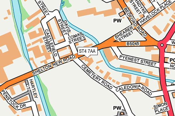
ST4 7AA lies on Shelton New Road in Stoke-on-trent. ST4 7AA is located in the Etruria & Hanley electoral ward, within the unitary authority of Stoke-on-Trent and the English Parliamentary constituency of Stoke-on-Trent Central. The Sub Integrated Care Board (ICB) Location is NHS Staffordshire and Stoke-on-Trent ICB - 05W and the police force is Staffordshire. This postcode has been in use since January 1980.


GetTheData
Source: OS OpenMap – Local (Ordnance Survey)
Source: OS VectorMap District (Ordnance Survey)
Licence: Open Government Licence (requires attribution)
| Easting | 387188 |
| Northing | 346543 |
| Latitude | 53.016050 |
| Longitude | -2.192423 |
GetTheData
Source: Open Postcode Geo
Licence: Open Government Licence
| Street | Shelton New Road |
| Town/City | Stoke-on-trent |
| Country | England |
| Postcode District | ST4 |
| ➜ ST4 open data dashboard ➜ See where ST4 is on a map ➜ Where is Stoke-on-Trent? | |
GetTheData
Source: Land Registry Price Paid Data
Licence: Open Government Licence
Elevation or altitude of ST4 7AA as distance above sea level:
| Metres | Feet | |
|---|---|---|
| Elevation | 130m | 427ft |
Elevation is measured from the approximate centre of the postcode, to the nearest point on an OS contour line from OS Terrain 50, which has contour spacing of ten vertical metres.
➜ How high above sea level am I? Find the elevation of your current position using your device's GPS.
GetTheData
Source: Open Postcode Elevation
Licence: Open Government Licence
| Ward | Etruria & Hanley |
| Constituency | Stoke-on-trent Central |
GetTheData
Source: ONS Postcode Database
Licence: Open Government Licence
75, SHELTON NEW ROAD, STOKE-ON-TRENT, ST4 7AA 1998 25 SEP £30,000 |
77, SHELTON NEW ROAD, STOKE-ON-TRENT, ST4 7AA 1996 29 MAR £225,000 |
GetTheData
Source: HM Land Registry Price Paid Data
Licence: Contains HM Land Registry data © Crown copyright and database right 2024. This data is licensed under the Open Government Licence v3.0.
| June 2022 | Anti-social behaviour | On or near Castlefield Street | 166m |
| June 2022 | Anti-social behaviour | On or near Castlefield Street | 166m |
| June 2022 | Anti-social behaviour | On or near Castlefield Street | 166m |
| ➜ Get more crime data in our Crime section | |||
GetTheData
Source: data.police.uk
Licence: Open Government Licence
| Etruscan Street (Shelton New Road) | Shelton | 58m |
| Etruscan Street (Shelton New Road) | Shelton | 71m |
| Cemetery Road (Shelton New Road) | Shelton | 151m |
| Cemetery Road (Shelton New Road) | Shelton | 217m |
| Pyenest Street (Shelton New Road) | Shelton | 392m |
| Stoke-on-Trent Station | 1.2km |
| Longport Station | 3.3km |
| Longton Station | 4.7km |
GetTheData
Source: NaPTAN
Licence: Open Government Licence
GetTheData
Source: ONS Postcode Database
Licence: Open Government Licence


➜ Get more ratings from the Food Standards Agency
GetTheData
Source: Food Standards Agency
Licence: FSA terms & conditions
| Last Collection | |||
|---|---|---|---|
| Location | Mon-Fri | Sat | Distance |
| 17 Oriel Street | 17:00 | 11:30 | 466m |
| Etruria Vale Road | 17:30 | 11:00 | 471m |
| Howard Place | 17:30 | 11:15 | 517m |
GetTheData
Source: Dracos
Licence: Creative Commons Attribution-ShareAlike
| Facility | Distance |
|---|---|
| Shelton Pool (Closed) Simon Place, Stoke-on-trent Swimming Pool | 520m |
| Stoke On Trent College (Cauldon Campus) (Closed) Stoke Road, Stoke-on-trent Health and Fitness Gym, Sports Hall | 622m |
| Stoke White Rock Speedway Westhead Walk, Stoke-on-trent Cycling | 632m |
GetTheData
Source: Active Places
Licence: Open Government Licence
| School | Phase of Education | Distance |
|---|---|---|
| Regent College 77 Shelton New Road, 77 Shelton New Road, Stoke-on-Trent, ST4 7AA | Not applicable | 274m |
| PEAK EDUCATION - STOKE 60 SNOWHILL, SHELTON, STOKE ON TRENT, ST1 4LY | Not applicable | 516m |
| Stoke-on-Trent College Cauldon Campus, Stoke Road, Shelton, Stoke-on-Trent, ST4 2DG | 16 plus | 622m |
GetTheData
Source: Edubase
Licence: Open Government Licence
The below table lists the International Territorial Level (ITL) codes (formerly Nomenclature of Territorial Units for Statistics (NUTS) codes) and Local Administrative Units (LAU) codes for ST4 7AA:
| ITL 1 Code | Name |
|---|---|
| TLG | West Midlands (England) |
| ITL 2 Code | Name |
| TLG2 | Shropshire and Staffordshire |
| ITL 3 Code | Name |
| TLG23 | Stoke-on-Trent |
| LAU 1 Code | Name |
| E06000021 | Stoke-on-Trent |
GetTheData
Source: ONS Postcode Directory
Licence: Open Government Licence
The below table lists the Census Output Area (OA), Lower Layer Super Output Area (LSOA), and Middle Layer Super Output Area (MSOA) for ST4 7AA:
| Code | Name | |
|---|---|---|
| OA | E00072136 | |
| LSOA | E01014281 | Stoke-on-Trent 015A |
| MSOA | E02002965 | Stoke-on-Trent 015 |
GetTheData
Source: ONS Postcode Directory
Licence: Open Government Licence
| ST4 7GG | Hartley Court | 88m |
| ST4 7GF | Penstock Drive | 160m |
| ST4 7AQ | Castlefield Street | 176m |
| ST4 7AB | Shelton New Road | 195m |
| ST4 7GH | Tattershall Court | 203m |
| ST4 7AD | Davis Street | 213m |
| ST4 7AE | Lomas Street | 227m |
| ST1 5PF | Boatman Walk | 279m |
| ST1 5PY | Waterlily Close | 296m |
| ST4 7BB | Cliff Vale Place | 321m |
GetTheData
Source: Open Postcode Geo; Land Registry Price Paid Data
Licence: Open Government Licence