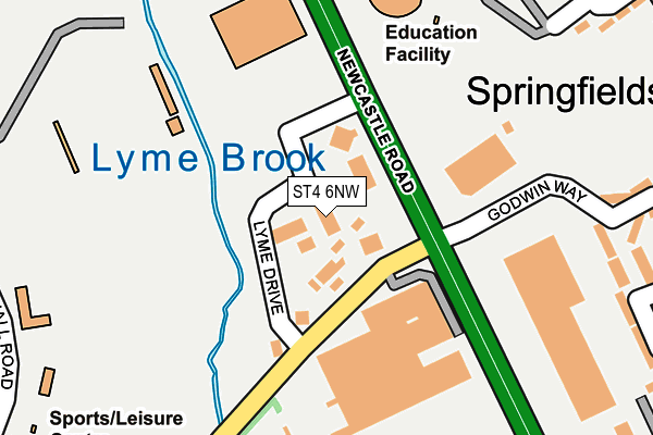
ST4 6NW is located in the Penkhull & Springfields electoral ward, within the unitary authority of Stoke-on-Trent and the English Parliamentary constituency of Stoke-on-Trent Central. The Sub Integrated Care Board (ICB) Location is NHS Staffordshire and Stoke-on-Trent ICB - 05W and the police force is Staffordshire. This postcode has been in use since July 1995.


GetTheData
Source: OS OpenMap – Local (Ordnance Survey)
Source: OS VectorMap District (Ordnance Survey)
Licence: Open Government Licence (requires attribution)
| Easting | 385869 |
| Northing | 344417 |
| Latitude | 52.996906 |
| Longitude | -2.211991 |
GetTheData
Source: Open Postcode Geo
Licence: Open Government Licence
| Country | England |
| Postcode District | ST4 |
| ➜ ST4 open data dashboard ➜ See where ST4 is on a map ➜ Where is Stoke-on-Trent? | |
GetTheData
Source: Land Registry Price Paid Data
Licence: Open Government Licence
Elevation or altitude of ST4 6NW as distance above sea level:
| Metres | Feet | |
|---|---|---|
| Elevation | 110m | 361ft |
Elevation is measured from the approximate centre of the postcode, to the nearest point on an OS contour line from OS Terrain 50, which has contour spacing of ten vertical metres.
➜ How high above sea level am I? Find the elevation of your current position using your device's GPS.
GetTheData
Source: Open Postcode Elevation
Licence: Open Government Licence
| Ward | Penkhull & Springfields |
| Constituency | Stoke-on-trent Central |
GetTheData
Source: ONS Postcode Database
Licence: Open Government Licence
| January 2024 | Other theft | On or near Lyme Drive | 39m |
| January 2024 | Other theft | On or near Lyme Drive | 39m |
| January 2024 | Violence and sexual offences | On or near Godwin Way | 295m |
| ➜ Get more crime data in our Crime section | |||
GetTheData
Source: data.police.uk
Licence: Open Government Licence
| The Orange Tree (Newcastle Road) | Springfields | 72m |
| Clayton Lane | Springfields | 108m |
| Clayton Lane | Springfields | 113m |
| Clayton Lane (Newcastle Road) | Springfields | 157m |
| Newcastle Lane (Newcastle Road) | Springfields | 180m |
| Stoke-on-Trent Station | 2.4km |
GetTheData
Source: NaPTAN
Licence: Open Government Licence
| Median download speed | 56.9Mbps |
| Average download speed | 51.4Mbps |
| Maximum download speed | 80.00Mbps |
| Median upload speed | 15.0Mbps |
| Average upload speed | 13.1Mbps |
| Maximum upload speed | 20.00Mbps |
GetTheData
Source: Ofcom
Licence: Ofcom Terms of Use (requires attribution)
GetTheData
Source: ONS Postcode Database
Licence: Open Government Licence


➜ Get more ratings from the Food Standards Agency
GetTheData
Source: Food Standards Agency
Licence: FSA terms & conditions
| Last Collection | |||
|---|---|---|---|
| Location | Mon-Fri | Sat | Distance |
| Harpfields Road | 18:00 | 09:30 | 493m |
| Newcastle Lane | 17:30 | 09:30 | 796m |
| The Avenue | 18:00 | 09:45 | 933m |
GetTheData
Source: Dracos
Licence: Creative Commons Attribution-ShareAlike
| Facility | Distance |
|---|---|
| Red Industries Lyme Valley Stadium Lilleshall Road, Newcastle Grass Pitches, Cycling | 178m |
| M Club Spa And Fitness (Newcastle) Lyme Drive, Trent Vale, Stoke-on-trent Swimming Pool, Health and Fitness Gym, Studio, Squash Courts | 188m |
| St. Johns Ce(A) Primary School Wheatly Avenue, Springfields, Stoke-on-trent Grass Pitches | 220m |
GetTheData
Source: Active Places
Licence: Open Government Licence
| School | Phase of Education | Distance |
|---|---|---|
| St John's CofE (A) Primary School Wheatly Avenue, Trent Vale, Stoke-on-Trent, ST4 6SB | Primary | 307m |
| Thistley Hough Academy Thistley Hough, Penkhull, Stoke-on-Trent, ST4 5JJ | Secondary | 735m |
| Clayton Hall Academy Clayton Lane, Clayton, Newcastle-under-Lyme, ST5 3DN | Secondary | 1km |
GetTheData
Source: Edubase
Licence: Open Government Licence
The below table lists the International Territorial Level (ITL) codes (formerly Nomenclature of Territorial Units for Statistics (NUTS) codes) and Local Administrative Units (LAU) codes for ST4 6NW:
| ITL 1 Code | Name |
|---|---|
| TLG | West Midlands (England) |
| ITL 2 Code | Name |
| TLG2 | Shropshire and Staffordshire |
| ITL 3 Code | Name |
| TLG23 | Stoke-on-Trent |
| LAU 1 Code | Name |
| E06000021 | Stoke-on-Trent |
GetTheData
Source: ONS Postcode Directory
Licence: Open Government Licence
The below table lists the Census Output Area (OA), Lower Layer Super Output Area (LSOA), and Middle Layer Super Output Area (MSOA) for ST4 6NW:
| Code | Name | |
|---|---|---|
| OA | E00072423 | |
| LSOA | E01014341 | Stoke-on-Trent 023B |
| MSOA | E02002973 | Stoke-on-Trent 023 |
GetTheData
Source: ONS Postcode Directory
Licence: Open Government Licence
| ST4 6JT | Archers Walk | 274m |
| ST4 6PE | Newcastle Road | 280m |
| ST4 6SA | Wheatley Avenue | 289m |
| ST4 6JS | Godwin Way | 306m |
| ST4 6RY | Springfields Road | 326m |
| ST5 3BX | Lilleshall Road | 332m |
| ST4 6JP | Godwin Way | 359m |
| ST4 6JU | Raleigh Close | 365m |
| ST4 6PN | Leaside Road | 374m |
| ST5 3BT | Bunny Hill | 381m |
GetTheData
Source: Open Postcode Geo; Land Registry Price Paid Data
Licence: Open Government Licence