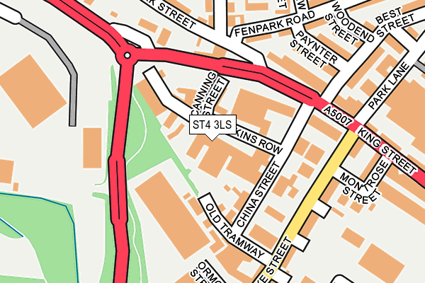
ST4 3LS is located in the Fenton West & Mount Pleasant electoral ward, within the unitary authority of Stoke-on-Trent and the English Parliamentary constituency of Stoke-on-Trent South. The Sub Integrated Care Board (ICB) Location is NHS Staffordshire and Stoke-on-Trent ICB - 05W and the police force is Staffordshire. This postcode has been in use since January 1980.


GetTheData
Source: OS OpenMap – Local (Ordnance Survey)
Source: OS VectorMap District (Ordnance Survey)
Licence: Open Government Licence (requires attribution)
| Easting | 389711 |
| Northing | 344348 |
| Latitude | 52.996357 |
| Longitude | -2.154746 |
GetTheData
Source: Open Postcode Geo
Licence: Open Government Licence
| Country | England |
| Postcode District | ST4 |
| ➜ ST4 open data dashboard ➜ See where ST4 is on a map ➜ Where is Stoke-on-Trent? | |
GetTheData
Source: Land Registry Price Paid Data
Licence: Open Government Licence
Elevation or altitude of ST4 3LS as distance above sea level:
| Metres | Feet | |
|---|---|---|
| Elevation | 140m | 459ft |
Elevation is measured from the approximate centre of the postcode, to the nearest point on an OS contour line from OS Terrain 50, which has contour spacing of ten vertical metres.
➜ How high above sea level am I? Find the elevation of your current position using your device's GPS.
GetTheData
Source: Open Postcode Elevation
Licence: Open Government Licence
| Ward | Fenton West & Mount Pleasant |
| Constituency | Stoke-on-trent South |
GetTheData
Source: ONS Postcode Database
Licence: Open Government Licence
| January 2024 | Other theft | On or near Rubian Street | 177m |
| January 2024 | Violence and sexual offences | On or near Rubian Street | 177m |
| January 2024 | Burglary | On or near Duke Street | 347m |
| ➜ Get more crime data in our Crime section | |||
GetTheData
Source: data.police.uk
Licence: Open Government Licence
| Duke Of Wellington (King Street) | Fenton | 114m |
| Duke Street (King Street) | Fenton | 117m |
| Park Street | Fenton | 134m |
| Park Street | Fenton | 136m |
| Duke Street (King Street) | Fenton | 324m |
| Longton Station | 1.4km |
| Stoke-on-Trent Station | 2.2km |
GetTheData
Source: NaPTAN
Licence: Open Government Licence
GetTheData
Source: ONS Postcode Database
Licence: Open Government Licence


➜ Get more ratings from the Food Standards Agency
GetTheData
Source: Food Standards Agency
Licence: FSA terms & conditions
| Last Collection | |||
|---|---|---|---|
| Location | Mon-Fri | Sat | Distance |
| Warrington Street | 17:20 | 11:30 | 472m |
| Heron Cross Post Office | 17:30 | 11:45 | 596m |
| East Fenton Post Office | 17:15 | 12:00 | 625m |
GetTheData
Source: Dracos
Licence: Creative Commons Attribution-ShareAlike
| Facility | Distance |
|---|---|
| Jd Gyms (Stoke) King Street, Stoke-on-trent Health and Fitness Gym, Studio | 102m |
| The Scout Hut (Glebedale Road) (Closed) Glebedale Road, Stoke-on-trent Sports Hall | 496m |
| Lifestyle Fitness (Stoke) (Closed) Victoria Road, Stoke-on-trent Health and Fitness Gym, Studio | 559m |
GetTheData
Source: Active Places
Licence: Open Government Licence
| School | Phase of Education | Distance |
|---|---|---|
| Co-Op Academy Glebe Park Place, Fenton, Stoke-on-Trent, ST4 3HZ | Primary | 379m |
| Christ Church CofE Primary Academy William Street, Fenton, Stoke-on-Trent, ST4 2JG | Primary | 853m |
| Our Lady's Catholic Academy Watkin Street, Fenton, Stoke-on-Trent, ST4 4NP | Primary | 854m |
GetTheData
Source: Edubase
Licence: Open Government Licence
The below table lists the International Territorial Level (ITL) codes (formerly Nomenclature of Territorial Units for Statistics (NUTS) codes) and Local Administrative Units (LAU) codes for ST4 3LS:
| ITL 1 Code | Name |
|---|---|
| TLG | West Midlands (England) |
| ITL 2 Code | Name |
| TLG2 | Shropshire and Staffordshire |
| ITL 3 Code | Name |
| TLG23 | Stoke-on-Trent |
| LAU 1 Code | Name |
| E06000021 | Stoke-on-Trent |
GetTheData
Source: ONS Postcode Directory
Licence: Open Government Licence
The below table lists the Census Output Area (OA), Lower Layer Super Output Area (LSOA), and Middle Layer Super Output Area (MSOA) for ST4 3LS:
| Code | Name | |
|---|---|---|
| OA | E00072079 | |
| LSOA | E01014279 | Stoke-on-Trent 020E |
| MSOA | E02002970 | Stoke-on-Trent 020 |
GetTheData
Source: ONS Postcode Directory
Licence: Open Government Licence
| ST4 3PA | Duke Street | 138m |
| ST4 3LZ | King Street | 163m |
| ST4 3NA | King Street | 166m |
| ST4 3JJ | Fenpark Road | 170m |
| ST4 3NZ | Milford Street | 177m |
| ST4 3NT | Duke Street | 182m |
| ST4 3NY | Abercorn Street | 189m |
| ST4 3JL | Paynter Street | 189m |
| ST4 3RR | Ormonde Street | 211m |
| ST4 3JF | Appleton Court | 217m |
GetTheData
Source: Open Postcode Geo; Land Registry Price Paid Data
Licence: Open Government Licence