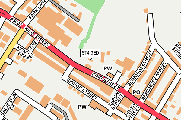
ST4 3ED is located in the Fenton East electoral ward, within the unitary authority of Stoke-on-Trent and the English Parliamentary constituency of Stoke-on-Trent South. The Sub Integrated Care Board (ICB) Location is NHS Staffordshire and Stoke-on-Trent ICB - 05W and the police force is Staffordshire. This postcode has been in use since August 1993.


GetTheData
Source: OS OpenMap – Local (Ordnance Survey)
Source: OS VectorMap District (Ordnance Survey)
Licence: Open Government Licence (requires attribution)
| Easting | 390145 |
| Northing | 344251 |
| Latitude | 52.995510 |
| Longitude | -2.148276 |
GetTheData
Source: Open Postcode Geo
Licence: Open Government Licence
| Country | England |
| Postcode District | ST4 |
| ➜ ST4 open data dashboard ➜ See where ST4 is on a map ➜ Where is Stoke-on-Trent? | |
GetTheData
Source: Land Registry Price Paid Data
Licence: Open Government Licence
Elevation or altitude of ST4 3ED as distance above sea level:
| Metres | Feet | |
|---|---|---|
| Elevation | 150m | 492ft |
Elevation is measured from the approximate centre of the postcode, to the nearest point on an OS contour line from OS Terrain 50, which has contour spacing of ten vertical metres.
➜ How high above sea level am I? Find the elevation of your current position using your device's GPS.
GetTheData
Source: Open Postcode Elevation
Licence: Open Government Licence
| Ward | Fenton East |
| Constituency | Stoke-on-trent South |
GetTheData
Source: ONS Postcode Database
Licence: Open Government Licence
| January 2024 | Bicycle theft | On or near Bute Street | 293m |
| January 2024 | Criminal damage and arson | On or near Bute Street | 293m |
| January 2024 | Shoplifting | On or near Bute Street | 293m |
| ➜ Get more crime data in our Crime section | |||
GetTheData
Source: data.police.uk
Licence: Open Government Licence
| Royal Street (King Street) | Fenton | 99m |
| Duke Street (King Street) | Fenton | 121m |
| Berdmore Street (King Street) | Fenton | 229m |
| Fenpark Road | Fenpark | 359m |
| Fenpark Road | Fenpark | 363m |
| Longton Station | 1km |
| Stoke-on-Trent Station | 2.6km |
| Wedgwood Station | 5.2km |
GetTheData
Source: NaPTAN
Licence: Open Government Licence
GetTheData
Source: ONS Postcode Database
Licence: Open Government Licence


➜ Get more ratings from the Food Standards Agency
GetTheData
Source: Food Standards Agency
Licence: FSA terms & conditions
| Last Collection | |||
|---|---|---|---|
| Location | Mon-Fri | Sat | Distance |
| East Fenton Post Office | 17:15 | 12:00 | 195m |
| King Street Old Post Office | 17:30 | 12:00 | 200m |
| Fenpark Road | 17:30 | 11:15 | 505m |
GetTheData
Source: Dracos
Licence: Creative Commons Attribution-ShareAlike
| Facility | Distance |
|---|---|
| Jd Gyms (Stoke) King Street, Stoke-on-trent Health and Fitness Gym, Studio | 381m |
| Co-op Academy Clarice Cliff Goldenhill Road, Stoke-on-trent Grass Pitches | 671m |
| Priors Fields Goldenhill Road, Stoke-on-trent Grass Pitches | 746m |
GetTheData
Source: Active Places
Licence: Open Government Licence
| School | Phase of Education | Distance |
|---|---|---|
| Co-Op Academy Clarice Cliff Goldenhill Road, Fenton, Stoke-on-Trent, ST4 3DP | Primary | 631m |
| Co-Op Academy Glebe Park Place, Fenton, Stoke-on-Trent, ST4 3HZ | Primary | 765m |
| St Thomas More Catholic Academy Longton Hall Road, Longton, Stoke-on-Trent, ST3 2NJ | Secondary | 851m |
GetTheData
Source: Edubase
Licence: Open Government Licence
The below table lists the International Territorial Level (ITL) codes (formerly Nomenclature of Territorial Units for Statistics (NUTS) codes) and Local Administrative Units (LAU) codes for ST4 3ED:
| ITL 1 Code | Name |
|---|---|
| TLG | West Midlands (England) |
| ITL 2 Code | Name |
| TLG2 | Shropshire and Staffordshire |
| ITL 3 Code | Name |
| TLG23 | Stoke-on-Trent |
| LAU 1 Code | Name |
| E06000021 | Stoke-on-Trent |
GetTheData
Source: ONS Postcode Directory
Licence: Open Government Licence
The below table lists the Census Output Area (OA), Lower Layer Super Output Area (LSOA), and Middle Layer Super Output Area (MSOA) for ST4 3ED:
| Code | Name | |
|---|---|---|
| OA | E00072097 | |
| LSOA | E01014274 | Stoke-on-Trent 020A |
| MSOA | E02002970 | Stoke-on-Trent 020 |
GetTheData
Source: ONS Postcode Directory
Licence: Open Government Licence
| ST4 3ET | King Street | 70m |
| ST4 3EN | King Street | 87m |
| ST4 3PF | Bishop Street | 87m |
| ST4 3PG | Oldfield Street | 108m |
| ST4 3EX | Burnham Street | 144m |
| ST4 3PQ | Oldfield Street | 151m |
| ST4 3PH | Baron Street | 166m |
| ST4 3EY | Burnham Street | 177m |
| ST4 3EZ | Brocksford Street | 192m |
| ST4 3EJ | King Street | 193m |
GetTheData
Source: Open Postcode Geo; Land Registry Price Paid Data
Licence: Open Government Licence