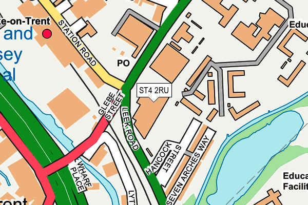
ST4 2RU is located in the Hanley Park, Joiner's Square & Shelton electoral ward, within the unitary authority of Stoke-on-Trent and the English Parliamentary constituency of Stoke-on-Trent Central. The Sub Integrated Care Board (ICB) Location is NHS Staffordshire and Stoke-on-Trent ICB - 05W and the police force is Staffordshire. This postcode has been in use since August 2010.


GetTheData
Source: OS OpenMap – Local (Ordnance Survey)
Source: OS VectorMap District (Ordnance Survey)
Licence: Open Government Licence (requires attribution)
| Easting | 388156 |
| Northing | 345512 |
| Latitude | 53.006787 |
| Longitude | -2.177957 |
GetTheData
Source: Open Postcode Geo
Licence: Open Government Licence
| Country | England |
| Postcode District | ST4 |
| ➜ ST4 open data dashboard ➜ See where ST4 is on a map ➜ Where is Stoke-on-Trent? | |
GetTheData
Source: Land Registry Price Paid Data
Licence: Open Government Licence
Elevation or altitude of ST4 2RU as distance above sea level:
| Metres | Feet | |
|---|---|---|
| Elevation | 110m | 361ft |
Elevation is measured from the approximate centre of the postcode, to the nearest point on an OS contour line from OS Terrain 50, which has contour spacing of ten vertical metres.
➜ How high above sea level am I? Find the elevation of your current position using your device's GPS.
GetTheData
Source: Open Postcode Elevation
Licence: Open Government Licence
| Ward | Hanley Park, Joiner's Square & Shelton |
| Constituency | Stoke-on-trent Central |
GetTheData
Source: ONS Postcode Database
Licence: Open Government Licence
| December 2023 | Violence and sexual offences | On or near Lordship Lane | 337m |
| December 2023 | Violence and sexual offences | On or near Lordship Lane | 337m |
| November 2023 | Violence and sexual offences | On or near Lordship Lane | 337m |
| ➜ Get more crime data in our Crime section | |||
GetTheData
Source: data.police.uk
Licence: Open Government Licence
| Hancock Street (Leek Road) | Stoke-upon-trent | 96m |
| Seven Arches (Leek Road) | Stoke-upon-trent | 234m |
| Civic Centre (Copeland Street) | Stoke-upon-trent | 269m |
| Stoke-on-trent Railway Station (Station Road) | Stoke-upon-trent | 279m |
| Stoke-on-trent Railway Station (Station Road) | Stoke-upon-trent | 295m |
| Stoke-on-Trent Station | 0.2km |
| Longton Station | 3.3km |
| Longport Station | 4.7km |
GetTheData
Source: NaPTAN
Licence: Open Government Licence
GetTheData
Source: ONS Postcode Database
Licence: Open Government Licence


➜ Get more ratings from the Food Standards Agency
GetTheData
Source: Food Standards Agency
Licence: FSA terms & conditions
| Last Collection | |||
|---|---|---|---|
| Location | Mon-Fri | Sat | Distance |
| Stoke Railway Station | 18:00 | 12:00 | 232m |
| Ashford Street | 17:30 | 10:15 | 361m |
| Glebe Street | 18:30 | 11:45 | 364m |
GetTheData
Source: Dracos
Licence: Creative Commons Attribution-ShareAlike
| Facility | Distance |
|---|---|
| Sir Stanley Matthews Sports Centre Leek Road, Stoke-on-trent Artificial Grass Pitch, Health and Fitness Gym, Grass Pitches, Sports Hall, Studio | 302m |
| City Of Stoke On Trent Sixth Form College Grass Pitches (Closed) Victoria Road, Fenton, Stoke-on-trent Grass Pitches, Artificial Grass Pitch | 565m |
| St Peters Academy Fenton Manor, Stoke-on-trent Health and Fitness Gym, Sports Hall, Studio, Artificial Grass Pitch, Grass Pitches, Outdoor Tennis Courts | 602m |
GetTheData
Source: Active Places
Licence: Open Government Licence
| School | Phase of Education | Distance |
|---|---|---|
| City of Stoke-On-Trent Sixth Form College Leek Road, Stoke-on-Trent, ST4 2RU | 16 plus | 57m |
| Staffordshire University College Road, Stoke-on-Trent, ST4 2DE | Not applicable | 313m |
| Excellence Girls Academy CROWTHER STREET, SHELTON, STOKE-ON-TRENT, STAFFORDSHIRE, ST4 2ER | Not applicable | 546m |
GetTheData
Source: Edubase
Licence: Open Government Licence
The below table lists the International Territorial Level (ITL) codes (formerly Nomenclature of Territorial Units for Statistics (NUTS) codes) and Local Administrative Units (LAU) codes for ST4 2RU:
| ITL 1 Code | Name |
|---|---|
| TLG | West Midlands (England) |
| ITL 2 Code | Name |
| TLG2 | Shropshire and Staffordshire |
| ITL 3 Code | Name |
| TLG23 | Stoke-on-Trent |
| LAU 1 Code | Name |
| E06000021 | Stoke-on-Trent |
GetTheData
Source: ONS Postcode Directory
Licence: Open Government Licence
The below table lists the Census Output Area (OA), Lower Layer Super Output Area (LSOA), and Middle Layer Super Output Area (MSOA) for ST4 2RU:
| Code | Name | |
|---|---|---|
| OA | E00072123 | |
| LSOA | E01014284 | Stoke-on-Trent 016F |
| MSOA | E02002966 | Stoke-on-Trent 016 |
GetTheData
Source: ONS Postcode Directory
Licence: Open Government Licence
| ST4 2AR | 146m | |
| ST4 2BD | Thornton Road | 211m |
| ST4 2BB | Boughey Road | 263m |
| ST4 2BE | Spencer Road | 291m |
| ST4 1JN | Brook Street | 302m |
| ST4 1HG | Glebe Street | 304m |
| ST4 1PR | Copeland Street | 324m |
| ST4 2BW | Leek Road | 331m |
| ST4 2BG | Carlton Road | 343m |
| ST4 1PP | Leason Street | 347m |
GetTheData
Source: Open Postcode Geo; Land Registry Price Paid Data
Licence: Open Government Licence