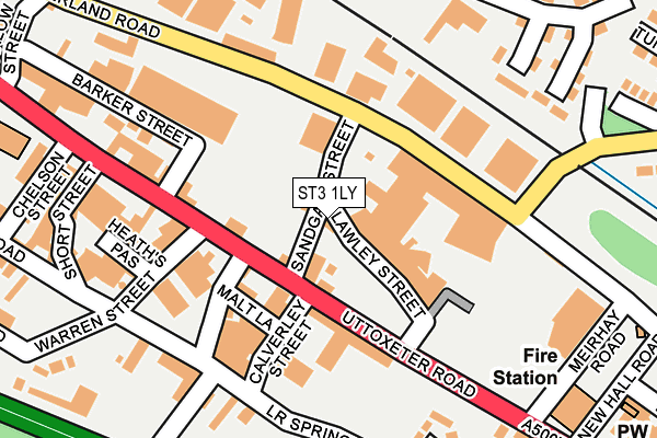
ST3 1LY is located in the Longton & Meir Hay South electoral ward, within the unitary authority of Stoke-on-Trent and the English Parliamentary constituency of Stoke-on-Trent South. The Sub Integrated Care Board (ICB) Location is NHS Staffordshire and Stoke-on-Trent ICB - 05W and the police force is Staffordshire. This postcode has been in use since January 2004.


GetTheData
Source: OS OpenMap – Local (Ordnance Survey)
Source: OS VectorMap District (Ordnance Survey)
Licence: Open Government Licence (requires attribution)
| Easting | 391755 |
| Northing | 343049 |
| Latitude | 52.984732 |
| Longitude | -2.124258 |
GetTheData
Source: Open Postcode Geo
Licence: Open Government Licence
| Country | England |
| Postcode District | ST3 |
| ➜ ST3 open data dashboard ➜ See where ST3 is on a map ➜ Where is Stoke-on-Trent? | |
GetTheData
Source: Land Registry Price Paid Data
Licence: Open Government Licence
Elevation or altitude of ST3 1LY as distance above sea level:
| Metres | Feet | |
|---|---|---|
| Elevation | 160m | 525ft |
Elevation is measured from the approximate centre of the postcode, to the nearest point on an OS contour line from OS Terrain 50, which has contour spacing of ten vertical metres.
➜ How high above sea level am I? Find the elevation of your current position using your device's GPS.
GetTheData
Source: Open Postcode Elevation
Licence: Open Government Licence
| Ward | Longton & Meir Hay South |
| Constituency | Stoke-on-trent South |
GetTheData
Source: ONS Postcode Database
Licence: Open Government Licence
| August 2023 | Violence and sexual offences | On or near Skye Close | 486m |
| June 2022 | Anti-social behaviour | On or near Heath'S Passage | 211m |
| June 2022 | Criminal damage and arson | On or near Kendrick Street | 275m |
| ➜ Get more crime data in our Crime section | |||
GetTheData
Source: data.police.uk
Licence: Open Government Licence
| Calverley Street (Uttoxeter Road) | Normacot | 90m |
| Longton Fire Station (Uttoxeter Road) | Normacot | 156m |
| Sutherland Road (Weston Coyney Road) | Meir Hay | 170m |
| Sutherland Road (Weston Coyney Road) | Meir Hay | 179m |
| Sutherland Road | Longton | 184m |
| Longton Station | 1km |
| Blythe Bridge Station | 4.3km |
| Stoke-on-Trent Station | 4.6km |
GetTheData
Source: NaPTAN
Licence: Open Government Licence
GetTheData
Source: ONS Postcode Database
Licence: Open Government Licence
➜ Get more ratings from the Food Standards Agency
GetTheData
Source: Food Standards Agency
Licence: FSA terms & conditions
| Last Collection | |||
|---|---|---|---|
| Location | Mon-Fri | Sat | Distance |
| Normacot Post Office | 17:00 | 12:00 | 473m |
| Lilleshall Street | 16:00 | 11:00 | 542m |
| Gladstone Pottery | 14:45 | 550m | |
GetTheData
Source: Dracos
Licence: Creative Commons Attribution-ShareAlike
| Facility | Distance |
|---|---|
| Normacot Recreation Ground Pitsford Street, Stoke-on-trent Grass Pitches | 392m |
| Watery Lane Playing Fields Watery Lane, Stoke-on-trent Grass Pitches | 817m |
| Florence Colliery Social Welfare Centre Lightwood Road, Stoke-on-trent Grass Pitches, Artificial Grass Pitch | 910m |
GetTheData
Source: Active Places
Licence: Open Government Licence
| School | Phase of Education | Distance |
|---|---|---|
| Alexandra Infants' School Melville Road, Normacot, Stoke-on-Trent, ST3 4PZ | Primary | 549m |
| Intuition Holistic Education 20, Rosslyn Road, Longton, Stoke-on-Trent, ST3 4JD | Not applicable | 644m |
| Belgrave St Bartholomew's Academy Sussex Place, Longton, Stoke-on-Trent, ST3 4TP | Primary | 881m |
GetTheData
Source: Edubase
Licence: Open Government Licence
The below table lists the International Territorial Level (ITL) codes (formerly Nomenclature of Territorial Units for Statistics (NUTS) codes) and Local Administrative Units (LAU) codes for ST3 1LY:
| ITL 1 Code | Name |
|---|---|
| TLG | West Midlands (England) |
| ITL 2 Code | Name |
| TLG2 | Shropshire and Staffordshire |
| ITL 3 Code | Name |
| TLG23 | Stoke-on-Trent |
| LAU 1 Code | Name |
| E06000021 | Stoke-on-Trent |
GetTheData
Source: ONS Postcode Directory
Licence: Open Government Licence
The below table lists the Census Output Area (OA), Lower Layer Super Output Area (LSOA), and Middle Layer Super Output Area (MSOA) for ST3 1LY:
| Code | Name | |
|---|---|---|
| OA | E00072218 | |
| LSOA | E01014302 | Stoke-on-Trent 022D |
| MSOA | E02002972 | Stoke-on-Trent 022 |
GetTheData
Source: ONS Postcode Directory
Licence: Open Government Licence
| ST3 1QN | Uttoxeter Road | 66m |
| ST3 1JB | Sutherland Road | 70m |
| ST3 1QQ | Uttoxeter Road | 103m |
| ST3 1QH | Uttoxeter Road | 112m |
| ST3 1QU | Bell Avenue | 207m |
| ST3 1RA | Normacot Road | 208m |
| ST3 1RD | Locketts Lane | 209m |
| ST3 1QD | Warren Street | 211m |
| ST3 1HZ | Sutherland Road | 234m |
| ST3 5QL | Uttoxeter Road | 256m |
GetTheData
Source: Open Postcode Geo; Land Registry Price Paid Data
Licence: Open Government Licence