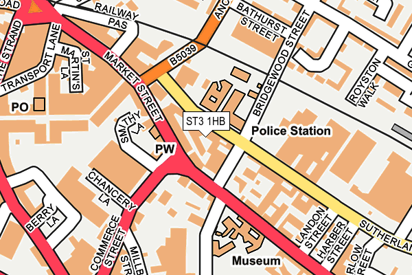
ST3 1HB is located in the Longton & Meir Hay South electoral ward, within the unitary authority of Stoke-on-Trent and the English Parliamentary constituency of Stoke-on-Trent South. The Sub Integrated Care Board (ICB) Location is NHS Staffordshire and Stoke-on-Trent ICB - 05W and the police force is Staffordshire. This postcode has been in use since January 1992.


GetTheData
Source: OS OpenMap – Local (Ordnance Survey)
Source: OS VectorMap District (Ordnance Survey)
Licence: Open Government Licence (requires attribution)
| Easting | 391217 |
| Northing | 343403 |
| Latitude | 52.987889 |
| Longitude | -2.132282 |
GetTheData
Source: Open Postcode Geo
Licence: Open Government Licence
| Country | England |
| Postcode District | ST3 |
| ➜ ST3 open data dashboard ➜ See where ST3 is on a map ➜ Where is Stoke-on-Trent? | |
GetTheData
Source: Land Registry Price Paid Data
Licence: Open Government Licence
Elevation or altitude of ST3 1HB as distance above sea level:
| Metres | Feet | |
|---|---|---|
| Elevation | 150m | 492ft |
Elevation is measured from the approximate centre of the postcode, to the nearest point on an OS contour line from OS Terrain 50, which has contour spacing of ten vertical metres.
➜ How high above sea level am I? Find the elevation of your current position using your device's GPS.
GetTheData
Source: Open Postcode Elevation
Licence: Open Government Licence
| Ward | Longton & Meir Hay South |
| Constituency | Stoke-on-trent South |
GetTheData
Source: ONS Postcode Database
Licence: Open Government Licence
| January 2024 | Public order | On or near Stretton Close | 182m |
| January 2024 | Other crime | On or near Bathurst Street | 191m |
| January 2024 | Other crime | On or near Bathurst Street | 191m |
| ➜ Get more crime data in our Crime section | |||
GetTheData
Source: data.police.uk
Licence: Open Government Licence
| Longton Police Station (Sutherland Road) | Longton | 62m |
| Longton Police Station (Sutherland Road) | Longton | 64m |
| Gladstone Pottery (Uttoxeter Road) | Longton | 98m |
| Gladstone Pottery (Uttoxeter Road) | Longton | 127m |
| Sutherland Road (Anchor Road) | Longton | 129m |
| Longton Station | 0.4km |
| Stoke-on-Trent Station | 4km |
| Wedgwood Station | 4.8km |
GetTheData
Source: NaPTAN
Licence: Open Government Licence
GetTheData
Source: ONS Postcode Database
Licence: Open Government Licence


➜ Get more ratings from the Food Standards Agency
GetTheData
Source: Food Standards Agency
Licence: FSA terms & conditions
| Last Collection | |||
|---|---|---|---|
| Location | Mon-Fri | Sat | Distance |
| Gladstone Pottery | 14:45 | 123m | |
| The Strand | 17:30 | 11:00 | 291m |
| Ashwood | 18:00 | 10:15 | 605m |
GetTheData
Source: Dracos
Licence: Creative Commons Attribution-ShareAlike
| Facility | Distance |
|---|---|
| Portland Health And Leisure King Street, Stoke-on-trent Health and Fitness Gym | 537m |
| St Gregory's Catholic Academy Spring Garden Road, Longton, Stoke-on-trent Grass Pitches | 625m |
| Edensor Technology College (Closed) Greendock Street, Longton, Stoke-on-trent Swimming Pool, Sports Hall, Grass Pitches | 642m |
GetTheData
Source: Active Places
Licence: Open Government Licence
| School | Phase of Education | Distance |
|---|---|---|
| Intuition Holistic Education 20, Rosslyn Road, Longton, Stoke-on-Trent, ST3 4JD | Not applicable | 572m |
| St Gregory's Catholic Academy Spring Garden Road, Longton, Stoke-on-Trent, ST3 2QN | Primary | 670m |
| Gladstone Primary Academy Anchor Road, Sandford Hill, Longton, Stoke-on-Trent, ST3 5EW | Primary | 677m |
GetTheData
Source: Edubase
Licence: Open Government Licence
The below table lists the International Territorial Level (ITL) codes (formerly Nomenclature of Territorial Units for Statistics (NUTS) codes) and Local Administrative Units (LAU) codes for ST3 1HB:
| ITL 1 Code | Name |
|---|---|
| TLG | West Midlands (England) |
| ITL 2 Code | Name |
| TLG2 | Shropshire and Staffordshire |
| ITL 3 Code | Name |
| TLG23 | Stoke-on-Trent |
| LAU 1 Code | Name |
| E06000021 | Stoke-on-Trent |
GetTheData
Source: ONS Postcode Directory
Licence: Open Government Licence
The below table lists the Census Output Area (OA), Lower Layer Super Output Area (LSOA), and Middle Layer Super Output Area (MSOA) for ST3 1HB:
| Code | Name | |
|---|---|---|
| OA | E00072209 | |
| LSOA | E01014302 | Stoke-on-Trent 022D |
| MSOA | E02002972 | Stoke-on-Trent 022 |
GetTheData
Source: ONS Postcode Directory
Licence: Open Government Licence
| ST3 1BW | Market Street | 37m |
| ST3 1NX | Uttoxeter Road | 42m |
| ST3 1BS | Market Street | 101m |
| ST3 1NY | Uttoxeter Road | 150m |
| ST3 1NP | Stretton Close | 164m |
| ST3 1JL | Bathurst Street | 207m |
| ST3 1NG | Whitegate Grove | 219m |
| ST3 1BX | Market Street | 223m |
| ST3 1TW | Landon Street | 224m |
| ST3 1BE | Market Street | 227m |
GetTheData
Source: Open Postcode Geo; Land Registry Price Paid Data
Licence: Open Government Licence