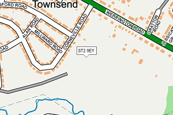
ST2 9EY is located in the Bentilee, Ubberley & Townsend electoral ward, within the unitary authority of Stoke-on-Trent and the English Parliamentary constituency of Stoke-on-Trent Central. The Sub Integrated Care Board (ICB) Location is NHS Staffordshire and Stoke-on-Trent ICB - 05W and the police force is Staffordshire. This postcode has been in use since January 1980.


GetTheData
Source: OS OpenMap – Local (Ordnance Survey)
Source: OS VectorMap District (Ordnance Survey)
Licence: Open Government Licence (requires attribution)
| Easting | 391298 |
| Northing | 347239 |
| Latitude | 53.022373 |
| Longitude | -2.131180 |
GetTheData
Source: Open Postcode Geo
Licence: Open Government Licence
| Country | England |
| Postcode District | ST2 |
| ➜ ST2 open data dashboard ➜ See where ST2 is on a map | |
GetTheData
Source: Land Registry Price Paid Data
Licence: Open Government Licence
Elevation or altitude of ST2 9EY as distance above sea level:
| Metres | Feet | |
|---|---|---|
| Elevation | 150m | 492ft |
Elevation is measured from the approximate centre of the postcode, to the nearest point on an OS contour line from OS Terrain 50, which has contour spacing of ten vertical metres.
➜ How high above sea level am I? Find the elevation of your current position using your device's GPS.
GetTheData
Source: Open Postcode Elevation
Licence: Open Government Licence
| Ward | Bentilee, Ubberley & Townsend |
| Constituency | Stoke-on-trent Central |
GetTheData
Source: ONS Postcode Database
Licence: Open Government Licence
| January 2024 | Anti-social behaviour | On or near Deaville Road | 382m |
| December 2023 | Criminal damage and arson | On or near Deaville Road | 382m |
| November 2023 | Other theft | On or near Deaville Road | 382m |
| ➜ Get more crime data in our Crime section | |||
GetTheData
Source: data.police.uk
Licence: Open Government Licence
| Corneville Road (Werrington Road) | Townsend | 172m |
| Lillydale Road | Bucknall | 274m |
| Lillydale Road | Bucknall | 275m |
| Jessica Grove (Werrington Road) | Townsend | 280m |
| Corneville Road | Bucknall | 298m |
| Longton Station | 3.6km |
| Stoke-on-Trent Station | 3.7km |
GetTheData
Source: NaPTAN
Licence: Open Government Licence
GetTheData
Source: ONS Postcode Database
Licence: Open Government Licence


➜ Get more ratings from the Food Standards Agency
GetTheData
Source: Food Standards Agency
Licence: FSA terms & conditions
| Last Collection | |||
|---|---|---|---|
| Location | Mon-Fri | Sat | Distance |
| Wendling Close | 17:45 | 09:30 | 1,090m |
| Leek Road | 18:15 | 09:00 | 2,146m |
| Northwood Post Office | 17:30 | 11:45 | 2,537m |
GetTheData
Source: Dracos
Licence: Creative Commons Attribution-ShareAlike
| Facility | Distance |
|---|---|
| The Discovery Academy (Closed) Corneville Road, Stoke-on-trent Sports Hall, Grass Pitches, Studio | 30m |
| St Maria Goretti Catholic Academy Aylesbury Road, Stoke-on-trent Grass Pitches | 452m |
| Kingsland C Of E Academy Werrington Road, Stoke-on-trent Grass Pitches | 501m |
GetTheData
Source: Active Places
Licence: Open Government Licence
| School | Phase of Education | Distance |
|---|---|---|
| St Maria Goretti Catholic Academy Aylesbury Road, Bentilee, Stoke-on-Trent, ST2 0LY | Primary | 510m |
| Kingsland CofE Academy Werrington Road, Bucknall, Stoke-on-Trent, ST2 9AS | Primary | 512m |
| Merit Hospital School and Medical Pupil Referral Unit Willeton Street, Bucknall, Willeton Street, Bucknall, Stoke-on-Trent, ST2 9JA | Not applicable | 837m |
GetTheData
Source: Edubase
Licence: Open Government Licence
The below table lists the International Territorial Level (ITL) codes (formerly Nomenclature of Territorial Units for Statistics (NUTS) codes) and Local Administrative Units (LAU) codes for ST2 9EY:
| ITL 1 Code | Name |
|---|---|
| TLG | West Midlands (England) |
| ITL 2 Code | Name |
| TLG2 | Shropshire and Staffordshire |
| ITL 3 Code | Name |
| TLG23 | Stoke-on-Trent |
| LAU 1 Code | Name |
| E06000021 | Stoke-on-Trent |
GetTheData
Source: ONS Postcode Directory
Licence: Open Government Licence
The below table lists the Census Output Area (OA), Lower Layer Super Output Area (LSOA), and Middle Layer Super Output Area (MSOA) for ST2 9EY:
| Code | Name | |
|---|---|---|
| OA | E00071781 | |
| LSOA | E01014218 | Stoke-on-Trent 014A |
| MSOA | E02002964 | Stoke-on-Trent 014 |
GetTheData
Source: ONS Postcode Directory
Licence: Open Government Licence
| ST2 9EU | Corneville Road | 79m |
| ST2 9ET | Corneville Road | 98m |
| ST2 9EX | Millward Road | 147m |
| ST2 9AD | Werrington Road | 157m |
| ST2 9AE | Werrington Road | 224m |
| ST2 9ES | Alan Road | 236m |
| ST2 9HA | Langford Road | 237m |
| ST2 0JJ | Trowbridge Crescent | 243m |
| ST2 9EZ | Langford Road | 257m |
| ST2 9AA | Dorset Close | 259m |
GetTheData
Source: Open Postcode Geo; Land Registry Price Paid Data
Licence: Open Government Licence