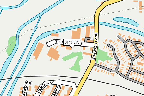
ST18 0YJ is located in the Baswich electoral ward, within the local authority district of Stafford and the English Parliamentary constituency of Stafford. The Sub Integrated Care Board (ICB) Location is NHS Staffordshire and Stoke-on-Trent ICB - 05V and the police force is Staffordshire. This postcode has been in use since March 1988.


GetTheData
Source: OS OpenMap – Local (Ordnance Survey)
Source: OS VectorMap District (Ordnance Survey)
Licence: Open Government Licence (requires attribution)
| Easting | 394529 |
| Northing | 322651 |
| Latitude | 52.801403 |
| Longitude | -2.082585 |
GetTheData
Source: Open Postcode Geo
Licence: Open Government Licence
| Country | England |
| Postcode District | ST18 |
| ➜ ST18 open data dashboard ➜ See where ST18 is on a map ➜ Where is Stafford? | |
GetTheData
Source: Land Registry Price Paid Data
Licence: Open Government Licence
Elevation or altitude of ST18 0YJ as distance above sea level:
| Metres | Feet | |
|---|---|---|
| Elevation | 80m | 262ft |
Elevation is measured from the approximate centre of the postcode, to the nearest point on an OS contour line from OS Terrain 50, which has contour spacing of ten vertical metres.
➜ How high above sea level am I? Find the elevation of your current position using your device's GPS.
GetTheData
Source: Open Postcode Elevation
Licence: Open Government Licence
| Ward | Baswich |
| Constituency | Stafford |
GetTheData
Source: ONS Postcode Database
Licence: Open Government Licence
| June 2022 | Burglary | On or near Dolphin Close | 340m |
| May 2022 | Violence and sexual offences | On or near Truro Way | 324m |
| April 2022 | Violence and sexual offences | On or near Danta Way | 254m |
| ➜ Get more crime data in our Crime section | |||
GetTheData
Source: data.police.uk
Licence: Open Government Licence
| Witney Road (Shipston Road) | Baswich | 291m |
| Holy Trinity Church (Baswich Lane) | Baswich | 408m |
| Burford Road (Compton Road) | Baswich | 437m |
| Wolseley Road (Tixall Road) | Kingston Hill | 482m |
| 256 Tixall Road (Tixall Road) | Kingston Hill | 485m |
| Stafford Station | 2.7km |
GetTheData
Source: NaPTAN
Licence: Open Government Licence
GetTheData
Source: ONS Postcode Database
Licence: Open Government Licence


➜ Get more ratings from the Food Standards Agency
GetTheData
Source: Food Standards Agency
Licence: FSA terms & conditions
| Last Collection | |||
|---|---|---|---|
| Location | Mon-Fri | Sat | Distance |
| The Saltings | 17:15 | 10:00 | 104m |
| Baswich Crescent | 17:15 | 09:45 | 649m |
| Avon Rise | 17:15 | 09:15 | 729m |
GetTheData
Source: Dracos
Licence: Creative Commons Attribution-ShareAlike
| Facility | Distance |
|---|---|
| St Leonards Works (Sport & Social Club) (Closed) St. Leonards Avenue, Stafford Sports Hall | 806m |
| Leasowes Primary School Porlock Avenue, Stafford Grass Pitches | 1.1km |
| Perkins Sports Club Tixall Road, Stafford Grass Pitches | 1.1km |
GetTheData
Source: Active Places
Licence: Open Government Licence
| School | Phase of Education | Distance |
|---|---|---|
| St Leonard's Primary School Fairway, Stafford, ST16 3TW | Primary | 806m |
| Leasowes Primary School Porlock Avenue, Weeping Cross, Stafford, ST17 0HT | Primary | 1.1km |
| St Anne's Catholic Primary School Lynton Avenue, Weeping Cross, Stafford, ST17 0EA | Primary | 1.2km |
GetTheData
Source: Edubase
Licence: Open Government Licence
The below table lists the International Territorial Level (ITL) codes (formerly Nomenclature of Territorial Units for Statistics (NUTS) codes) and Local Administrative Units (LAU) codes for ST18 0YJ:
| ITL 1 Code | Name |
|---|---|
| TLG | West Midlands (England) |
| ITL 2 Code | Name |
| TLG2 | Shropshire and Staffordshire |
| ITL 3 Code | Name |
| TLG24 | Staffordshire CC |
| LAU 1 Code | Name |
| E07000197 | Stafford |
GetTheData
Source: ONS Postcode Directory
Licence: Open Government Licence
The below table lists the Census Output Area (OA), Lower Layer Super Output Area (LSOA), and Middle Layer Super Output Area (MSOA) for ST18 0YJ:
| Code | Name | |
|---|---|---|
| OA | E00151628 | |
| LSOA | E01029758 | Stafford 014F |
| MSOA | E02006201 | Stafford 014 |
GetTheData
Source: ONS Postcode Directory
Licence: Open Government Licence
| ST18 0YE | Baswich Lane | 221m |
| ST17 0BB | Cypress Close | 232m |
| ST17 0BA | Danta Way | 247m |
| ST17 0BP | Witney Road | 263m |
| ST17 0BD | Baywood Close | 285m |
| ST17 0BW | Shipston Road | 309m |
| ST17 0AZ | Dolphin Close | 329m |
| ST17 0FH | Truro Way | 330m |
| ST17 0AY | Kestrel Close | 358m |
| ST17 0AU | Fairview Way | 426m |
GetTheData
Source: Open Postcode Geo; Land Registry Price Paid Data
Licence: Open Government Licence