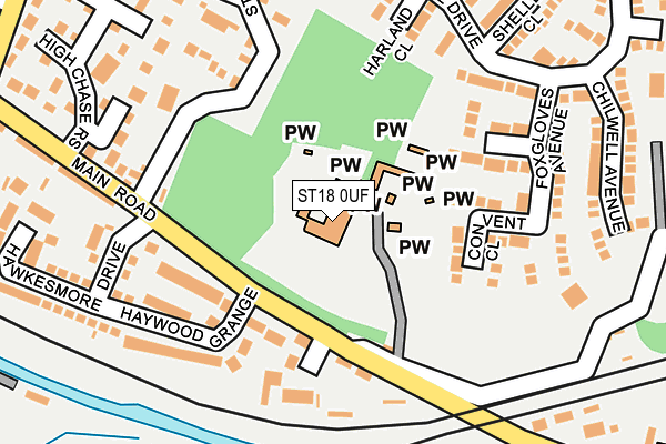
ST18 0UF is located in the Haywood & Hixon electoral ward, within the local authority district of Stafford and the English Parliamentary constituency of Stafford. The Sub Integrated Care Board (ICB) Location is NHS Staffordshire and Stoke-on-Trent ICB - 05V and the police force is Staffordshire. This postcode has been in use since January 1980.


GetTheData
Source: OS OpenMap – Local (Ordnance Survey)
Source: OS VectorMap District (Ordnance Survey)
Licence: Open Government Licence (requires attribution)
| Easting | 400814 |
| Northing | 321383 |
| Latitude | 52.790017 |
| Longitude | -1.989370 |
GetTheData
Source: Open Postcode Geo
Licence: Open Government Licence
| Country | England |
| Postcode District | ST18 |
| ➜ ST18 open data dashboard ➜ See where ST18 is on a map ➜ Where is Little Haywood? | |
GetTheData
Source: Land Registry Price Paid Data
Licence: Open Government Licence
Elevation or altitude of ST18 0UF as distance above sea level:
| Metres | Feet | |
|---|---|---|
| Elevation | 80m | 262ft |
Elevation is measured from the approximate centre of the postcode, to the nearest point on an OS contour line from OS Terrain 50, which has contour spacing of ten vertical metres.
➜ How high above sea level am I? Find the elevation of your current position using your device's GPS.
GetTheData
Source: Open Postcode Elevation
Licence: Open Government Licence
| Ward | Haywood & Hixon |
| Constituency | Stafford |
GetTheData
Source: ONS Postcode Database
Licence: Open Government Licence
| February 2023 | Criminal damage and arson | On or near St Mary'S Road | 172m |
| June 2022 | Anti-social behaviour | On or near Ashtree Close | 236m |
| June 2022 | Violence and sexual offences | On or near Forest Close | 328m |
| ➜ Get more crime data in our Crime section | |||
GetTheData
Source: data.police.uk
Licence: Open Government Licence
| St Marys Abbey (Main Rd) | Little Haywood | 97m |
| St Marys Abbey (Main Rd) | Little Haywood | 109m |
| Lamb & Flag Ph (Main Road) | Little Haywood | 312m |
| Lamb & Flag Ph (Main Rd) | Little Haywood | 323m |
| St Michael And All Angels Church (Main Road) | Colwich | 342m |
| Rugeley Trent Valley Station | 4.6km |
| Rugeley Town Station | 5.3km |
GetTheData
Source: NaPTAN
Licence: Open Government Licence
| Percentage of properties with Next Generation Access | 100.0% |
| Percentage of properties with Superfast Broadband | 100.0% |
| Percentage of properties with Ultrafast Broadband | 0.0% |
| Percentage of properties with Full Fibre Broadband | 0.0% |
Superfast Broadband is between 30Mbps and 300Mbps
Ultrafast Broadband is > 300Mbps
| Percentage of properties unable to receive 2Mbps | 0.0% |
| Percentage of properties unable to receive 5Mbps | 0.0% |
| Percentage of properties unable to receive 10Mbps | 0.0% |
| Percentage of properties unable to receive 30Mbps | 0.0% |
GetTheData
Source: Ofcom
Licence: Ofcom Terms of Use (requires attribution)
GetTheData
Source: ONS Postcode Database
Licence: Open Government Licence


➜ Get more ratings from the Food Standards Agency
GetTheData
Source: Food Standards Agency
Licence: FSA terms & conditions
| Last Collection | |||
|---|---|---|---|
| Location | Mon-Fri | Sat | Distance |
| Little Haywood Post Office | 17:00 | 08:15 | 241m |
| Coley Lane | 17:00 | 09:00 | 425m |
| Wolsley Close | 17:00 | 08:30 | 620m |
GetTheData
Source: Dracos
Licence: Creative Commons Attribution-ShareAlike
| Facility | Distance |
|---|---|
| Little Haywood Jubilee Playing Fields Main Road, Little Haywood, Stafford Grass Pitches, Cycling | 864m |
| Shugborough Estate (Closed) Shugborough, Stafford Grass Pitches | 1.4km |
| Mount Road West Butts Road, Rugeley Grass Pitches | 3.5km |
GetTheData
Source: Active Places
Licence: Open Government Licence
| School | Phase of Education | Distance |
|---|---|---|
| Colwich CofE Primary School Main Road, Colwich, Stafford, ST17 0XD | Primary | 398m |
| Anson CofE Primary School Main Road, Great Haywood, Stafford, ST18 0SU | Primary | 1.6km |
| St John's Catholic Primary School School Lane, Great Haywood, Stafford, ST18 0SL | Primary | 1.6km |
GetTheData
Source: Edubase
Licence: Open Government Licence
The below table lists the International Territorial Level (ITL) codes (formerly Nomenclature of Territorial Units for Statistics (NUTS) codes) and Local Administrative Units (LAU) codes for ST18 0UF:
| ITL 1 Code | Name |
|---|---|
| TLG | West Midlands (England) |
| ITL 2 Code | Name |
| TLG2 | Shropshire and Staffordshire |
| ITL 3 Code | Name |
| TLG24 | Staffordshire CC |
| LAU 1 Code | Name |
| E07000197 | Stafford |
GetTheData
Source: ONS Postcode Directory
Licence: Open Government Licence
The below table lists the Census Output Area (OA), Lower Layer Super Output Area (LSOA), and Middle Layer Super Output Area (MSOA) for ST18 0UF:
| Code | Name | |
|---|---|---|
| OA | E00151394 | |
| LSOA | E01029711 | Stafford 008C |
| MSOA | E02006195 | Stafford 008 |
GetTheData
Source: ONS Postcode Directory
Licence: Open Government Licence
| ST18 0UB | Haywood Grange | 142m |
| ST18 0QU | Convent Close | 143m |
| ST18 0UE | St Marys Grange | 146m |
| ST18 0QW | St Chads Close | 168m |
| ST18 0TX | Main Road | 182m |
| ST18 0NH | Woodside Close | 191m |
| ST18 0QT | Foxgloves Avenue | 202m |
| ST18 0JY | Harland Close | 215m |
| ST18 0TU | Main Road | 235m |
| ST18 0NN | Hillside Drive | 236m |
GetTheData
Source: Open Postcode Geo; Land Registry Price Paid Data
Licence: Open Government Licence