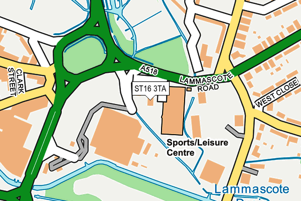
ST16 3TA lies on Lammascote Road in Stafford. ST16 3TA is located in the Forebridge electoral ward, within the local authority district of Stafford and the English Parliamentary constituency of Stafford. The Sub Integrated Care Board (ICB) Location is NHS Staffordshire and Stoke-on-Trent ICB - 05V and the police force is Staffordshire. This postcode has been in use since January 1980.


GetTheData
Source: OS OpenMap – Local (Ordnance Survey)
Source: OS VectorMap District (Ordnance Survey)
Licence: Open Government Licence (requires attribution)
| Easting | 392790 |
| Northing | 323138 |
| Latitude | 52.805760 |
| Longitude | -2.108390 |
GetTheData
Source: Open Postcode Geo
Licence: Open Government Licence
| Street | Lammascote Road |
| Town/City | Stafford |
| Country | England |
| Postcode District | ST16 |
➜ See where ST16 is on a map ➜ Where is Stafford? | |
GetTheData
Source: Land Registry Price Paid Data
Licence: Open Government Licence
Elevation or altitude of ST16 3TA as distance above sea level:
| Metres | Feet | |
|---|---|---|
| Elevation | 80m | 262ft |
Elevation is measured from the approximate centre of the postcode, to the nearest point on an OS contour line from OS Terrain 50, which has contour spacing of ten vertical metres.
➜ How high above sea level am I? Find the elevation of your current position using your device's GPS.
GetTheData
Source: Open Postcode Elevation
Licence: Open Government Licence
| Ward | Forebridge |
| Constituency | Stafford |
GetTheData
Source: ONS Postcode Database
Licence: Open Government Licence
ANSON HOUSE, LAMMASCOTE ROAD, STAFFORD, ST16 3TA 2020 6 APR £300,000 |
4, LAMMASCOTE ROAD, STAFFORD, ST16 3TA 1997 29 OCT £119,640 |
GetTheData
Source: HM Land Registry Price Paid Data
Licence: Contains HM Land Registry data © Crown copyright and database right 2025. This data is licensed under the Open Government Licence v3.0.
| Asda Store (Lammascote Road) | Stafford | 52m |
| Lammascote Road (Weston Road) | Littleworth | 254m |
| Hatherton Street (Fairway) | Littleworth | 257m |
| Bedford Avenue (Corporation Street) | Littleworth | 258m |
| Windermere House (Corporation Street) | Littleworth | 281m |
| Stafford Station | 0.9km |
GetTheData
Source: NaPTAN
Licence: Open Government Licence
GetTheData
Source: ONS Postcode Database
Licence: Open Government Licence


➜ Get more ratings from the Food Standards Agency
GetTheData
Source: Food Standards Agency
Licence: FSA terms & conditions
| Last Collection | |||
|---|---|---|---|
| Location | Mon-Fri | Sat | Distance |
| Sandon Road North | 17:30 | 09:30 | 218m |
| Eastgate Street | 17:30 | 11:45 | 249m |
| Littleworth Post Office | 17:00 | 12:00 | 415m |
GetTheData
Source: Dracos
Licence: Creative Commons Attribution-ShareAlike
| Risk of ST16 3TA flooding from rivers and sea | High |
| ➜ ST16 3TA flood map | |
GetTheData
Source: Open Flood Risk by Postcode
Licence: Open Government Licence
The below table lists the International Territorial Level (ITL) codes (formerly Nomenclature of Territorial Units for Statistics (NUTS) codes) and Local Administrative Units (LAU) codes for ST16 3TA:
| ITL 1 Code | Name |
|---|---|
| TLG | West Midlands (England) |
| ITL 2 Code | Name |
| TLG2 | Shropshire and Staffordshire |
| ITL 3 Code | Name |
| TLG24 | Staffordshire CC |
| LAU 1 Code | Name |
| E07000197 | Stafford |
GetTheData
Source: ONS Postcode Directory
Licence: Open Government Licence
The below table lists the Census Output Area (OA), Lower Layer Super Output Area (LSOA), and Middle Layer Super Output Area (MSOA) for ST16 3TA:
| Code | Name | |
|---|---|---|
| OA | E00166324 | |
| LSOA | E01029701 | Stafford 010E |
| MSOA | E02006197 | Stafford 010 |
GetTheData
Source: ONS Postcode Directory
Licence: Open Government Licence
| ST16 3LF | Corporation Street | 136m |
| ST16 3SW | Corporation Street | 136m |
| ST16 3TQ | Riverway | 202m |
| ST16 2LY | Eastgate Street | 238m |
| ST16 3TH | Riverway | 245m |
| ST16 3LQ | Corporation Street | 259m |
| ST16 3TG | West Close | 270m |
| ST16 3LP | Corporation Street | 289m |
| ST16 3RN | Weston Road | 293m |
| ST16 3TL | Fairway | 300m |
GetTheData
Source: Open Postcode Geo; Land Registry Price Paid Data
Licence: Open Government Licence