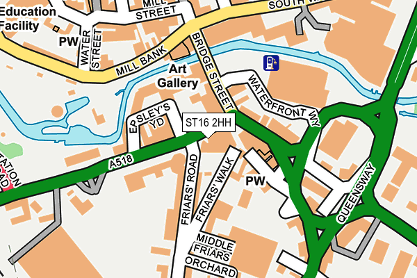
ST16 2HH is located in the Forebridge electoral ward, within the local authority district of Stafford and the English Parliamentary constituency of Stafford. The Sub Integrated Care Board (ICB) Location is NHS Staffordshire and Stoke-on-Trent ICB - 05V and the police force is Staffordshire. This postcode has been in use since January 1980.


GetTheData
Source: OS OpenMap – Local (Ordnance Survey)
Source: OS VectorMap District (Ordnance Survey)
Licence: Open Government Licence (requires attribution)
| Easting | 392286 |
| Northing | 322904 |
| Latitude | 52.803634 |
| Longitude | -2.115864 |
GetTheData
Source: Open Postcode Geo
Licence: Open Government Licence
| Country | England |
| Postcode District | ST16 |
➜ See where ST16 is on a map ➜ Where is Stafford? | |
GetTheData
Source: Land Registry Price Paid Data
Licence: Open Government Licence
Elevation or altitude of ST16 2HH as distance above sea level:
| Metres | Feet | |
|---|---|---|
| Elevation | 80m | 262ft |
Elevation is measured from the approximate centre of the postcode, to the nearest point on an OS contour line from OS Terrain 50, which has contour spacing of ten vertical metres.
➜ How high above sea level am I? Find the elevation of your current position using your device's GPS.
GetTheData
Source: Open Postcode Elevation
Licence: Open Government Licence
| Ward | Forebridge |
| Constituency | Stafford |
GetTheData
Source: ONS Postcode Database
Licence: Open Government Licence
| Pilgrim Street (Newport Road) | Stafford Town Centre | 28m |
| Wetherspoons Ph (Bridge Street) | Stafford Town Centre | 96m |
| Wetherspoons Ph (Bridge Street) | Stafford Town Centre | 98m |
| The Sun Ph (Lichfield Road) | Stafford Town Centre | 99m |
| Pilgrim Street (Newport Road) | Stafford Town Centre | 100m |
| Stafford Station | 0.4km |
GetTheData
Source: NaPTAN
Licence: Open Government Licence
| Percentage of properties with Next Generation Access | 100.0% |
| Percentage of properties with Superfast Broadband | 100.0% |
| Percentage of properties with Ultrafast Broadband | 33.3% |
| Percentage of properties with Full Fibre Broadband | 0.0% |
Superfast Broadband is between 30Mbps and 300Mbps
Ultrafast Broadband is > 300Mbps
| Percentage of properties unable to receive 2Mbps | 0.0% |
| Percentage of properties unable to receive 5Mbps | 0.0% |
| Percentage of properties unable to receive 10Mbps | 0.0% |
| Percentage of properties unable to receive 30Mbps | 0.0% |
GetTheData
Source: Ofcom
Licence: Ofcom Terms of Use (requires attribution)
GetTheData
Source: ONS Postcode Database
Licence: Open Government Licence


➜ Get more ratings from the Food Standards Agency
GetTheData
Source: Food Standards Agency
Licence: FSA terms & conditions
| Last Collection | |||
|---|---|---|---|
| Location | Mon-Fri | Sat | Distance |
| The Green | 17:15 | 09:30 | 108m |
| Stafford Post Office | 18:30 | 12:00 | 186m |
| Stafford Post Office | 18:30 | 12:00 | 189m |
GetTheData
Source: Dracos
Licence: Creative Commons Attribution-ShareAlike
| Risk of ST16 2HH flooding from rivers and sea | High |
| ➜ ST16 2HH flood map | |
GetTheData
Source: Open Flood Risk by Postcode
Licence: Open Government Licence
The below table lists the International Territorial Level (ITL) codes (formerly Nomenclature of Territorial Units for Statistics (NUTS) codes) and Local Administrative Units (LAU) codes for ST16 2HH:
| ITL 1 Code | Name |
|---|---|
| TLG | West Midlands (England) |
| ITL 2 Code | Name |
| TLG2 | Shropshire and Staffordshire |
| ITL 3 Code | Name |
| TLG24 | Staffordshire CC |
| LAU 1 Code | Name |
| E07000197 | Stafford |
GetTheData
Source: ONS Postcode Directory
Licence: Open Government Licence
The below table lists the Census Output Area (OA), Lower Layer Super Output Area (LSOA), and Middle Layer Super Output Area (MSOA) for ST16 2HH:
| Code | Name | |
|---|---|---|
| OA | E00151329 | |
| LSOA | E01029701 | Stafford 010E |
| MSOA | E02006197 | Stafford 010 |
GetTheData
Source: ONS Postcode Directory
Licence: Open Government Licence
| ST17 4BE | Cambridge Cottages | 33m |
| ST16 2HL | Bridge Street | 64m |
| ST16 2HJ | Bridge Street | 65m |
| ST16 2EZ | Newport Road | 74m |
| ST17 4AA | Friars Road | 110m |
| ST16 2BS | Espleys Yard | 114m |
| ST17 4JX | Lichfield Road | 122m |
| ST17 4AD | The Brooklands | 125m |
| ST16 2QZ | Mill Bank | 134m |
| ST16 2HY | Greengate Street | 139m |
GetTheData
Source: Open Postcode Geo; Land Registry Price Paid Data
Licence: Open Government Licence