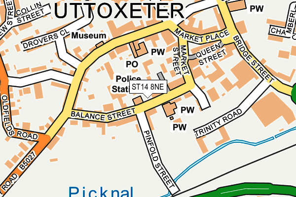
ST14 8NE is located in the Town electoral ward, within the local authority district of East Staffordshire and the English Parliamentary constituency of Burton. The Sub Integrated Care Board (ICB) Location is NHS Staffordshire and Stoke-on-Trent ICB - 05D and the police force is Staffordshire. This postcode has been in use since June 2016.


GetTheData
Source: OS OpenMap – Local (Ordnance Survey)
Source: OS VectorMap District (Ordnance Survey)
Licence: Open Government Licence (requires attribution)
| Easting | 409195 |
| Northing | 333324 |
| Latitude | 52.897301 |
| Longitude | -1.864757 |
GetTheData
Source: Open Postcode Geo
Licence: Open Government Licence
| Country | England |
| Postcode District | ST14 |
| ➜ ST14 open data dashboard ➜ See where ST14 is on a map ➜ Where is Uttoxeter? | |
GetTheData
Source: Land Registry Price Paid Data
Licence: Open Government Licence
Elevation or altitude of ST14 8NE as distance above sea level:
| Metres | Feet | |
|---|---|---|
| Elevation | 90m | 295ft |
Elevation is measured from the approximate centre of the postcode, to the nearest point on an OS contour line from OS Terrain 50, which has contour spacing of ten vertical metres.
➜ How high above sea level am I? Find the elevation of your current position using your device's GPS.
GetTheData
Source: Open Postcode Elevation
Licence: Open Government Licence
| Ward | Town |
| Constituency | Burton |
GetTheData
Source: ONS Postcode Database
Licence: Open Government Licence
| December 2023 | Shoplifting | On or near Shopping Area | 244m |
| December 2023 | Public order | On or near Shopping Area | 244m |
| December 2023 | Anti-social behaviour | On or near Shopping Area | 244m |
| ➜ Get more crime data in our Crime section | |||
GetTheData
Source: data.police.uk
Licence: Open Government Licence
| Post Office (Carter Street) | Uttoxeter | 132m |
| Trinity Road (Bridge Street) | Uttoxeter | 182m |
| Leisure Centre (Oldfields Road) | Balance Hill | 336m |
| Railway Station (Station Road) | Uttoxeter | 412m |
| Thomas Alleynes High School (Dove Bank (S)) | Uttoxeter Town Centre | 433m |
| Uttoxeter Station | 0.5km |
GetTheData
Source: NaPTAN
Licence: Open Government Licence
| Percentage of properties with Next Generation Access | 100.0% |
| Percentage of properties with Superfast Broadband | 100.0% |
| Percentage of properties with Ultrafast Broadband | 0.0% |
| Percentage of properties with Full Fibre Broadband | 0.0% |
Superfast Broadband is between 30Mbps and 300Mbps
Ultrafast Broadband is > 300Mbps
| Percentage of properties unable to receive 2Mbps | 0.0% |
| Percentage of properties unable to receive 5Mbps | 0.0% |
| Percentage of properties unable to receive 10Mbps | 0.0% |
| Percentage of properties unable to receive 30Mbps | 0.0% |
GetTheData
Source: Ofcom
Licence: Ofcom Terms of Use (requires attribution)
GetTheData
Source: ONS Postcode Database
Licence: Open Government Licence


➜ Get more ratings from the Food Standards Agency
GetTheData
Source: Food Standards Agency
Licence: FSA terms & conditions
| Last Collection | |||
|---|---|---|---|
| Location | Mon-Fri | Sat | Distance |
| Uttoxeter Post Office | 18:15 | 12:15 | 131m |
| Copes Way | 17:00 | 07:30 | 1,586m |
| Park Crescent | 16:00 | 08:00 | 2,559m |
GetTheData
Source: Dracos
Licence: Creative Commons Attribution-ShareAlike
| Facility | Distance |
|---|---|
| Bradley House Squash Club Bradley Street, Uttoxeter Squash Courts | 378m |
| Uttoxeter Leisure Centre Oldfields Road, Uttoxeter Sports Hall, Swimming Pool, Health and Fitness Gym, Squash Courts, Studio | 399m |
| Thomas Alleyne's High School Dove Bank, Uttoxeter Health and Fitness Gym, Grass Pitches, Sports Hall, Swimming Pool, Artificial Grass Pitch | 469m |
GetTheData
Source: Active Places
Licence: Open Government Licence
| School | Phase of Education | Distance |
|---|---|---|
| Thomas Alleyne's High School Dove Bank, Uttoxeter, ST14 8DU | Secondary | 467m |
| Picknalls First School Oldfields Road, Uttoxeter, ST14 7QL | Primary | 502m |
| St Joseph's Catholic Primary School Springfield Road, Uttoxeter, ST14 7JX | Primary | 569m |
GetTheData
Source: Edubase
Licence: Open Government Licence
The below table lists the International Territorial Level (ITL) codes (formerly Nomenclature of Territorial Units for Statistics (NUTS) codes) and Local Administrative Units (LAU) codes for ST14 8NE:
| ITL 1 Code | Name |
|---|---|
| TLG | West Midlands (England) |
| ITL 2 Code | Name |
| TLG2 | Shropshire and Staffordshire |
| ITL 3 Code | Name |
| TLG24 | Staffordshire CC |
| LAU 1 Code | Name |
| E07000193 | East Staffordshire |
GetTheData
Source: ONS Postcode Directory
Licence: Open Government Licence
The below table lists the Census Output Area (OA), Lower Layer Super Output Area (LSOA), and Middle Layer Super Output Area (MSOA) for ST14 8NE:
| Code | Name | |
|---|---|---|
| OA | E00150100 | |
| LSOA | E01029460 | East Staffordshire 003B |
| MSOA | E02006133 | East Staffordshire 003 |
GetTheData
Source: ONS Postcode Directory
Licence: Open Government Licence
| ST14 8HT | Spiceal Mews | 40m |
| ST14 8JD | Chartley Court | 62m |
| ST14 8JB | Balance Street | 64m |
| ST14 8HF | Market Place | 91m |
| ST14 8HY | Market Place | 100m |
| ST14 8HJ | Queen Street | 103m |
| ST14 8HP | Market Place | 127m |
| ST14 8HN | Market Place | 133m |
| ST14 8JE | Balance Street | 142m |
| ST14 8JQ | Balance Street | 148m |
GetTheData
Source: Open Postcode Geo; Land Registry Price Paid Data
Licence: Open Government Licence