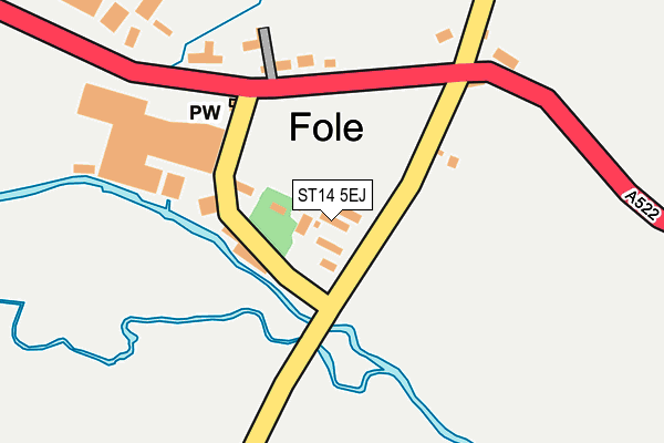
ST14 5EJ is located in the Checkley electoral ward, within the local authority district of Staffordshire Moorlands and the English Parliamentary constituency of Stone. The Sub Integrated Care Board (ICB) Location is NHS Staffordshire and Stoke-on-Trent ICB - 05G and the police force is Staffordshire. This postcode has been in use since January 1980.


GetTheData
Source: OS OpenMap – Local (Ordnance Survey)
Source: OS VectorMap District (Ordnance Survey)
Licence: Open Government Licence (requires attribution)
| Easting | 404531 |
| Northing | 337246 |
| Latitude | 52.932615 |
| Longitude | -1.934035 |
GetTheData
Source: Open Postcode Geo
Licence: Open Government Licence
| Country | England |
| Postcode District | ST14 |
| ➜ ST14 open data dashboard ➜ See where ST14 is on a map ➜ Where is Fole? | |
GetTheData
Source: Land Registry Price Paid Data
Licence: Open Government Licence
Elevation or altitude of ST14 5EJ as distance above sea level:
| Metres | Feet | |
|---|---|---|
| Elevation | 110m | 361ft |
Elevation is measured from the approximate centre of the postcode, to the nearest point on an OS contour line from OS Terrain 50, which has contour spacing of ten vertical metres.
➜ How high above sea level am I? Find the elevation of your current position using your device's GPS.
GetTheData
Source: Open Postcode Elevation
Licence: Open Government Licence
| Ward | Checkley |
| Constituency | Stone |
GetTheData
Source: ONS Postcode Database
Licence: Open Government Licence
| Co-op Dairy (Uttoxeter Road (A522)) | Fole | 129m |
| Co-op Dairy (Uttoxeter Road) | Fole | 155m |
| Green Park (Uttoxeter Road) | Checkley | 1,096m |
| Green Park (Uttoxeter Road) | Checkley | 1,207m |
GetTheData
Source: NaPTAN
Licence: Open Government Licence
| Percentage of properties with Next Generation Access | 100.0% |
| Percentage of properties with Superfast Broadband | 0.0% |
| Percentage of properties with Ultrafast Broadband | 0.0% |
| Percentage of properties with Full Fibre Broadband | 0.0% |
Superfast Broadband is between 30Mbps and 300Mbps
Ultrafast Broadband is > 300Mbps
| Percentage of properties unable to receive 2Mbps | 0.0% |
| Percentage of properties unable to receive 5Mbps | 0.0% |
| Percentage of properties unable to receive 10Mbps | 100.0% |
| Percentage of properties unable to receive 30Mbps | 100.0% |
GetTheData
Source: Ofcom
Licence: Ofcom Terms of Use (requires attribution)
GetTheData
Source: ONS Postcode Database
Licence: Open Government Licence


➜ Get more ratings from the Food Standards Agency
GetTheData
Source: Food Standards Agency
Licence: FSA terms & conditions
| Last Collection | |||
|---|---|---|---|
| Location | Mon-Fri | Sat | Distance |
| Copes Way | 17:00 | 07:30 | 4,508m |
| Wedgwood Road | 16:30 | 11:00 | 5,825m |
| Uttoxeter Post Office | 18:15 | 12:15 | 5,963m |
GetTheData
Source: Dracos
Licence: Creative Commons Attribution-ShareAlike
| Facility | Distance |
|---|---|
| Checkley Cricket Club Uttoxeter Road, Checkley, Stoke-on-trent Grass Pitches | 2.5km |
| Leigh Recreation Ground School Lane, Church Leigh, Leigh, Stoke-on-trent Grass Pitches | 2.6km |
| Greatwood Hall Hollington Road, Tean, Stoke-on-trent Sports Hall | 3.9km |
GetTheData
Source: Active Places
Licence: Open Government Licence
| School | Phase of Education | Distance |
|---|---|---|
| Hutchinson Memorial CofE First School Uttoxeter Road, Checkley, Stoke-on-Trent, ST10 4NB | Primary | 1.8km |
| All Saints' CofE First School School Lane, Church Leigh, Stoke-On-Trent, ST10 4SR | Primary | 2.6km |
| Great Wood Community Primary School Vicarage Road, Upper Tean, Stoke-on-Trent, ST10 4LE | Primary | 3.9km |
GetTheData
Source: Edubase
Licence: Open Government Licence
The below table lists the International Territorial Level (ITL) codes (formerly Nomenclature of Territorial Units for Statistics (NUTS) codes) and Local Administrative Units (LAU) codes for ST14 5EJ:
| ITL 1 Code | Name |
|---|---|
| TLG | West Midlands (England) |
| ITL 2 Code | Name |
| TLG2 | Shropshire and Staffordshire |
| ITL 3 Code | Name |
| TLG24 | Staffordshire CC |
| LAU 1 Code | Name |
| E07000198 | Staffordshire Moorlands |
GetTheData
Source: ONS Postcode Directory
Licence: Open Government Licence
The below table lists the Census Output Area (OA), Lower Layer Super Output Area (LSOA), and Middle Layer Super Output Area (MSOA) for ST14 5EJ:
| Code | Name | |
|---|---|---|
| OA | E00151798 | |
| LSOA | E01029788 | Staffordshire Moorlands 013C |
| MSOA | E02006216 | Staffordshire Moorlands 013 |
GetTheData
Source: ONS Postcode Directory
Licence: Open Government Licence
| ST14 5EW | 121m | |
| ST14 5EF | 179m | |
| ST14 5EE | Hollington Road | 432m |
| ST14 5ED | 1008m | |
| ST10 4NQ | Deadmans Green | 1084m |
| ST10 4QW | Green Park | 1229m |
| ST10 4HN | Hollington Fields | 1451m |
| ST10 4QH | Nobut Road | 1512m |
| ST10 4NG | St Marys Close | 1698m |
| ST10 4QJ | Nobut Road | 1706m |
GetTheData
Source: Open Postcode Geo; Land Registry Price Paid Data
Licence: Open Government Licence