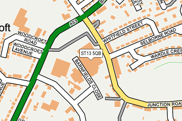
ST13 5QB is located in the Leek South electoral ward, within the local authority district of Staffordshire Moorlands and the English Parliamentary constituency of Staffordshire Moorlands. The Sub Integrated Care Board (ICB) Location is NHS Staffordshire and Stoke-on-Trent ICB - 05G and the police force is Staffordshire. This postcode has been in use since January 1980.


GetTheData
Source: OS OpenMap – Local (Ordnance Survey)
Source: OS VectorMap District (Ordnance Survey)
Licence: Open Government Licence (requires attribution)
| Easting | 397965 |
| Northing | 355826 |
| Latitude | 53.099630 |
| Longitude | -2.031845 |
GetTheData
Source: Open Postcode Geo
Licence: Open Government Licence
| Country | England |
| Postcode District | ST13 |
| ➜ ST13 open data dashboard ➜ See where ST13 is on a map ➜ Where is Leek? | |
GetTheData
Source: Land Registry Price Paid Data
Licence: Open Government Licence
Elevation or altitude of ST13 5QB as distance above sea level:
| Metres | Feet | |
|---|---|---|
| Elevation | 160m | 525ft |
Elevation is measured from the approximate centre of the postcode, to the nearest point on an OS contour line from OS Terrain 50, which has contour spacing of ten vertical metres.
➜ How high above sea level am I? Find the elevation of your current position using your device's GPS.
GetTheData
Source: Open Postcode Elevation
Licence: Open Government Licence
| Ward | Leek South |
| Constituency | Staffordshire Moorlands |
GetTheData
Source: ONS Postcode Database
Licence: Open Government Licence
| June 2022 | Other theft | On or near Barnfields Close | 56m |
| June 2022 | Anti-social behaviour | On or near Whitfield Street | 160m |
| June 2022 | Other theft | On or near Supermarket | 165m |
| ➜ Get more crime data in our Crime section | |||
GetTheData
Source: data.police.uk
Licence: Open Government Licence
| Morrisons (Junction Road) | Barnfields | 51m |
| Morrisons (Junction Rd) | Barnfields | 63m |
| Daintry Street (Broad St) | Barnfields | 181m |
| Daintry Street (Broad St) | Barnfields | 237m |
| Campbell Avenue (Newcastle Rd) | Barnfields | 255m |
GetTheData
Source: NaPTAN
Licence: Open Government Licence
GetTheData
Source: ONS Postcode Database
Licence: Open Government Licence


➜ Get more ratings from the Food Standards Agency
GetTheData
Source: Food Standards Agency
Licence: FSA terms & conditions
| Last Collection | |||
|---|---|---|---|
| Location | Mon-Fri | Sat | Distance |
| Burton Street | 17:00 | 11:00 | 194m |
| Campbell Avenue | 17:00 | 11:15 | 225m |
| Cruso Street | 17:45 | 11:00 | 382m |
GetTheData
Source: Dracos
Licence: Creative Commons Attribution-ShareAlike
| Facility | Distance |
|---|---|
| All Saints Ce First School Cheadle Road, Leek Grass Pitches | 614m |
| Future Fitness (Staffordshire) (Closed) Salisbury Street, Leek Health and Fitness Gym, Studio | 724m |
| Westwood First School Westwood Road, Leek Grass Pitches | 792m |
GetTheData
Source: Active Places
Licence: Open Government Licence
| School | Phase of Education | Distance |
|---|---|---|
| St Mary's Catholic Academy Cruso Street, Leek, ST13 8BW | Primary | 432m |
| All Saints CofE First School Cheadle Road, Leek, ST13 5QY | Primary | 614m |
| Woodcroft Academy Wallbridge Drive, Leek, ST13 8JG | Primary | 800m |
GetTheData
Source: Edubase
Licence: Open Government Licence
The below table lists the International Territorial Level (ITL) codes (formerly Nomenclature of Territorial Units for Statistics (NUTS) codes) and Local Administrative Units (LAU) codes for ST13 5QB:
| ITL 1 Code | Name |
|---|---|
| TLG | West Midlands (England) |
| ITL 2 Code | Name |
| TLG2 | Shropshire and Staffordshire |
| ITL 3 Code | Name |
| TLG24 | Staffordshire CC |
| LAU 1 Code | Name |
| E07000198 | Staffordshire Moorlands |
GetTheData
Source: ONS Postcode Directory
Licence: Open Government Licence
The below table lists the Census Output Area (OA), Lower Layer Super Output Area (LSOA), and Middle Layer Super Output Area (MSOA) for ST13 5QB:
| Code | Name | |
|---|---|---|
| OA | E00151921 | |
| LSOA | E01029811 | Staffordshire Moorlands 005C |
| MSOA | E02006208 | Staffordshire Moorlands 005 |
GetTheData
Source: ONS Postcode Directory
Licence: Open Government Licence
| ST13 5QW | Junction Road | 75m |
| ST13 5QN | Junction Road | 84m |
| ST13 5QL | Junction Road | 86m |
| ST13 5TY | Wallhill Court | 130m |
| ST13 5QA | Broad Street | 152m |
| ST13 5PH | Whitfield Street | 174m |
| ST13 8XZ | Hampton Court | 190m |
| ST13 5RW | Newcastle Road | 200m |
| ST13 5QG | Barnfield Road Industrial Estate | 206m |
| ST13 5QP | Junction Road | 209m |
GetTheData
Source: Open Postcode Geo; Land Registry Price Paid Data
Licence: Open Government Licence